June 27, 2016
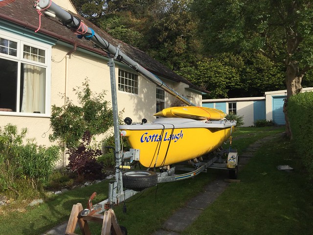
4th Used trimaran
So now we have 4 used, French, open-cockpit trimarans for sale. Never been able to offer this much choice before.
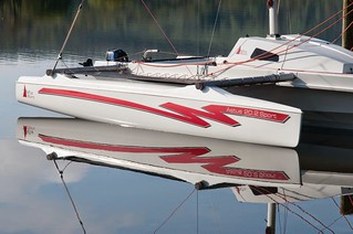
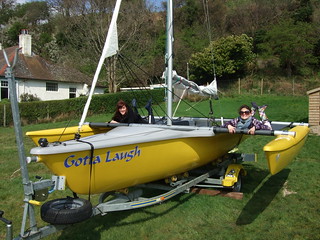
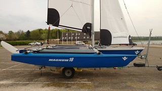
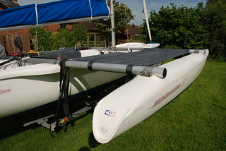
And of course their value has just gone up though the price remains the same. Because of the fall in the value of the pound it is now more expensive to buy a new one AND you'd have to wait for a new one. Whereas you can have one of these NOW. So pick up the phone, dial +44 (0)1244 676188 or +44 (0)7985 043 981, talk to me, Steve Walker, about these boats and make arrangements to see the one you fancy.
November 30, 2015
Magnum 21 for sale
If you are interested in this boat that is for sale for £7,500 please call me on 01244 676188 or 07985 043981 or use the Contact page.
April 06, 2011
3 Magnum 21 trimarans for sale
There are currently 3 used Magnum 21 trimarans for sale via Ahoy-Boats. Check out the Used Boats for Sale section by clicking the tab above and registering your interest.


February 01, 2011
Magnum demonstrator for sale
Our MAGNUM 21 trimaran demonstrator is for sale by tender.

Register your interest in this magnificent boat and we will email you a link to gain access to the very high specification and the bidding form.
As most people are thinking about skiing rather than sailing at the moment, bidding will stay open until reserve is reached.
June 21, 2010
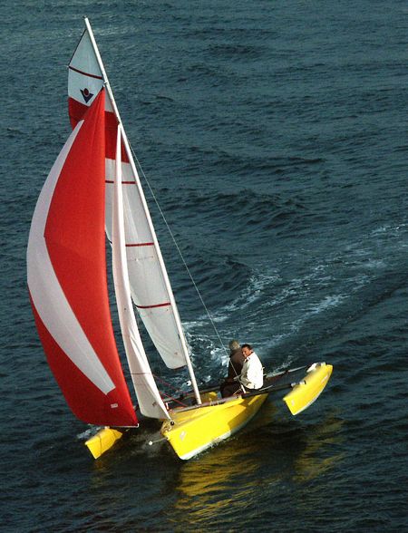
Round the Island Race in Magnum 21
Simon Creasey became the first Magnum 21 trimaran owner (to my knowledge) to compete in the Round the Island Race in a Magnum 21. These are the first pictures, and they capture the essence of the event, don't they? Lots and lots of sails.


I sometimes wonder if this straightforward anticlockwise race around the Isle of Wight were in the southern hemisphere, whether it would be sailed clockwise. Why do we run around athletics tracks anticlockwise and most of the horse race courses I can think of are run anticlockwise and does it feel unnatural to do this in the antipodes? I tried ice skating clockwise once in Paris and fell over immediately. The hoards of people skating anticlockwise at the same time might have had something to do with it! No doubt somebody can think of a clever answer to this conundrum.
But in the meantime, it's midsummer and there is still time to buy a boat for the summer hols. ORDER YOUR MAGNUM 21 NOW.
Photos of the Magnum 21 from ashore can be found at
https://www.flickr.com/photos/leightonian/4714554379/sizes/l/
https://www.flickr.com/photos/leightonian/4715195936/sizes/l/
https://www.flickr.com/photos/leightonian/4715194918/sizes/l/
and a slideshow mainly of monohulls flying colourful spinnakers during the run towards Hurst Castle can be seen at
https://www.flickr.com/photos/leightonian/show/with/4715496418/
I hope to have a brief article from Simon describing his experience soon.
And finally if you want to see where you could be heading when you start sailing with your trimaran have a look at this:
https://www.flickr.com/photos/leightonian/4715195012/sizes/l/
May 30, 2010
Lower Magnum 21 prices
The price of a typically specified Magnum 21 trimaran is about £2,500 lower than it was a year ago, when VAT was only 15%. This is because the pound has risen against a gradually weakening Euro since then. Also we have reduced our margins still further. The saving is equivalent to having a free road trailer.
VAT may well increase at the next budget, which is only a few weeks away. So NOW is an ideal moment to order a new boat. If VAT does increase there will be anti-avoidance legislation in place to make sure that you have to pay it.
So I recommend that you ORDER NOW!
April 23, 2010
Used Magnum 21 trimarans

We have a few Magnum 21 trimarans available. All in excellent condition. Click on For Sale above.
Also there is a rare opportunity to buy a little 16ft VirusPlus trimaran.
The sailing season is upon us and these boats represent excellent value!
October 28, 2009
Conwy & Great Orme

Maurice, a hale and hearty, 82 year old, Zimbabwean with a strong farmer's handshake, came for a Magnum 21 demonstration last week with his son, Des.
While I was putting the boat together the flood tide was ripping up the River Conwy against a fresh southerly wind. It was a good wind, not too much, but enough for a good sail. However, by the time we launched the tide was high and the wind had dropped away completely so I motored up the river to show my guests the spectacular Conwy Castle first.
We turned seaward again and after meandering through the moorings we launched the spinnaker. It hung limply from the mast! So we had lunch and waited for the wind.
The main channel follows the coast in a westerly direction but there is a second channel that goes north along the edge of the Great Orme and as the tide was in and the wind seemed to be from the west now we decided that we'd go that way. I'd never been this way by sea before and it is much more dramatic.

We crept alongside the Orme past "millionaires row" at about 3 knots using the GPS to avoid rocks after we'd seen one with a bird standing on it that, from a distance, we'd thought was another buoy!

When we were nearly at the end of the Orme we gybed and, of course were unable to sail upwind so we took the spi down and set the jib so we could beat back to Conwy against the ebb tide. You can see from the track just how well the Magnum 21 points upwind.

Eventually after ten tacks, as the time was running out and the tide was falling, we started the engine. I'll have to sail here again; it was fun.
Maurice and Des said they'd need a crocodile flap installing at the stern! First time I've ever been asked for one of those.
October 01, 2009
Wind Farm in a Magnum 21
Recently I sailed with Julie in a Magnum 21 trimaran out to a new wind farm being built off the North Wales coast on the Contable Bank, 5 miles from Rhos-on-Sea. Click the image below to view the VIDEO.

It was lovely day with a light breeze and so on the downwind sail back we got the spinnaker out. We sailed very close to a tug, Red Dolphin, which appeared from the land to be in amongst the turbines, guarding them, but in fact turned out to be only half way there!
This is the sort of thing that I love to do in the Magnum 21 trimaran. Take the boat somewhere and go and have a look at something from the sea that others without boats don't get to see. The wind farm was a great objective but the view to landward from the sea was always spectacular with the Great Orme, Llandudno, and the Berwyn and Snowdonia mountain ranges providing stunning backdrops to our afternoon sail.

We covered 11.5 nautical miles in 3 hrs 15 mins so our average speed was 3.5 knots. Our max speed was 6.4 knots, achieved when we did a little reaching before we approached the slipway on our return.
The next video I'll be editing together for you all is the final one in the assembly and rigging instructions, RIGGING the SPINNAKER of the MAGNUM 21.
June 03, 2009
Exciting Video in River Mersey
At last I have managed to get my hands on a little of the video taken last year when I circumnavigated the Wirral Peninsula in a Magnum 21, edit it and upload it to YouTube.
Yes this peninsula can be cirumnavigated! There is a canal from Chester to Ellesmere Port where the Manchester Ship canal offers access to the estuary of the mighty River Mersey. Some of the video was taken from a microlight but the most exhilarating trimaran clips, of sailing at speeds up to 12.5 knots, were taken from a launch kindly provided by Wallasey Yacht Club.
The winds were strong (hence the two reefs taken) and the water rough enough to inflate my life jacket during the first sortie into the waves at Eastham.
Helming the multihull in this savage river with its phenomenal tidal currents is Andy Todd from Chester Sailing and Canoe Club. Watch out for the Liverpool waterfront with all the new buildings before our exit into the Irish Sea and maybe catch a glimpse of the historic Leasowe lighthouse in the final shot.
June 02, 2009
Porth Dinllaen to Trevor on Lleyn Peninsula
Warm, light winds, calm seas, clear blue sky and brilliant sunshine, ideal for a gentle sail with a non-sailor in a Magnum 21 trimaran along the beautiful coast of the Lleyn Peninsula, that part of North Wales that juts out into the Irish Sea. Sailing in a Celtic day boat beside a Celtic land; how appropriate! How many Welsh children know, I wonder, that the language of Brittany in France, Breton, is very similar to Welsh?
Between Trevor and Port Dinllaen are seven of the most beautiful miles of Welsh coastline. They are peppered with Guillemots that fly as penguins ought to, with very rapid wing beats. These little brown and white auks dive whenever we come near to any afloat. You should hear the cacophony as we sail quietly by the steep cliff where they nest in a great colony. Listen. Watch. Enjoy. And then think about the many places you could drive to and sail from with a trailer sailer such as this Magnum 21.
May 13, 2009
Perfect Gybe
For those of you who have yet to discover the many clips of the Magnum 21 trimaran on this site, here is a taster.
Gybing with the spinnaker in a MAGNUM 21 trimaran looks easy! And see just how nimble this boat is. You would think that the helm is going to steer around the buoy in the picture but in fact the Magnum 21 stays on the same side of the buoy, spinning deftly on the spot and turning in its own length. This is because this small trimaran has a centreboard and because of the considerable rocker on the shortish outriggers and also the flatness of the planing principle hull at the stern. Multihulls have a reputation for being diffcult to turn (especially tack) but in fact it is mainly catamarans that fall into this category. This revolutionary French trimaran day boat by VirusBoats shows how clever design can transform sailing performance.
May 03, 2009
IN & OUT Takes from Rigging Videos
I had to get IN and OUT of the boat an awful lot of times to make the videos about the assembly and rigging of the Magnum 21 trimaran day boat!
Follow this link: Assembly & Rigging Instructional Videos and follow the instructions to gain full access.
Next week I'm off to France to create a video of the new V8 catamaran, the CREDIT CRUNCH CATAMARAN. I'll still be contactable on my mobile phone except when sailing and flying. It will take a week, at least, thereafter to edit the video but it will be worth the wait!
April 29, 2009
How to hoist the main sail of a Magnum
Here is a video showing how to rig and hoist the main sail of the Magnum 21 trimaran then finally set the jib so you can see the basic sail set. Of course this task would normally be done on the water. I quite like doing it at anchor or on a mooring, as the boat will then naturally turn head to wind, but it can be done also by motoring into the wind and anyway, if the jib is furled and the mainsheet traveller is in the centre, the trimaran will naturally head upwind though it will quietly tack alternately this way and that, so not ideal when you are trying to hoist the main. Being at anchor is good.
Follow this link: Assembly & Rigging Instructional Videos and follow the instructions to gain access.
I think you'll agree that the DIAX sails do look great in the sunshine at Hoylake on the tip of the Wirral peninsula.
April 23, 2009
Rigging the Magnum Genoa
When I started out on making these videos about the rigging of the Magnum 21 trimaran, it was this one that I wanted to make first because a customer who'd bought the Magnum Makeover kit had asked for instructions.
Follow this link: Assembly & Rigging Instructional Videos and follow the instructions to gain access.
If you've ever wondered much about sail trimming then the genoa is the sail that can explain it all to you. It's great to play with the barber hauler, watch the tell-tails and notice the change in speed as you adjust the flow of air around the sail.
With the barber hauler in tight, the direction of pull of the sheet on the clew of the sail is more downwards and so the foot of the sail can be maintained loose and curved while the top of the sail will be flatter.
On the other hand with the barber hauler loose, the genoa sheet will be pulling on the sail from the stern of the boat and this will tend to pull the foot of the genoa straighter and flatter whilst allowing the head of the sail to be more curved and loose. You might want to do this to allow wind to spill from the top of the sail in gusty conditions.
Usually you will want to get the direcion of pull such that it bisects the angle at the clew so that the line of the sheet is directed towards a point about half way up the luff. But the best way to trim the sail is to tune it with tell-tails. You want all the pairs of tell-tails to fly equally well. The leward ones that are in the faster flowing air on the outside of the curve lifting a little more than their counterparts on the inside of the sail. Or is it the other way around? You'll know when you see it. Have fun.
In the video the boat is positioned facing downwind so the tell-tails are not flying but drooping. However, you can see them flying in this photo taken last summer.

The next video will be about the main sail.
April 21, 2009
Rigging the jib sheet
The jib sheet on the Magnum 21 trimaran is simply arranged so that the load is halved thereby negating the requirement for any winches on the boat. Here is a short video explaing how it should be fitted.
Follow this link: Assembly & Rigging Instructional Videos and follow the instructions to gain access.
The next video I produce will be to show how the genoa should be rigged as this involves the use of barber haulers.
I do hope you appreciate these videos as they take a long time to record and an even longer time to edit! :)
April 16, 2009
Lifting trimaran mast
Raising the mast of the Magnum 21 has always been relatively easy. This short video shows you just how easy.
Follow this link: Assembly & Rigging Instructional Videos and follow the instructions to gain access.
April 09, 2009
How to Assemble and Rig a Magnum 21
Here is a video showing how easy it is to put a Magnum 21 trimaran together. It only covers the standing rigging. Assembly & Rigging Instructional Videos
March 15, 2009
1st Spring demo
Today I went sailing for the first time this year. Spring has sprung, the daffodils are up and the air is much warmer. The forecast was for light airs, which gave a perfect opportunity to try out all of the sails on the Magnum 21 at my favourite location, Beaumaris - the name says it all (beautiful sea).
First we beat up towards Bangor Pier and showed that we could go faster upwind with the genoa reaching 10.3 knots but not pointing as high. So after a bit of a play with the barber haulers to show the effects on the sail's trim we furled it again. Then we got the spinnaker out of its bag and had the usual fun and games getting it deployed correctly.
Once we'd sorted out the sheets we started by goose-winging downwind and then gybed to a broad reaach. The spinnaker is a big powerful sail that takes a lot of hanging onto when you approach a reach and we were tanking along again at between nine and ten knots and managed to reach 10.3 knots a second time.
We gybed a few times and sailed past close to the pier at Beaumaris so any onlookers might see the boat, which looks beautiful with her spinnaker up and she was indeed admired by somebody we spoke to in the café afterwards.
We were soon heading out towards Puffin Island but we were out of time and so so we beat back at between 5 and 6 knots with two of us standing on the windward float. This is only made posible by the extra shrouds that I had fitted to this boat, which you get as standard with the Magnum 21S and provide a greater feeling of security for the crew when out here. You can trapeze off them if you like.
Approaching the beach we furled the jib and, under the power of just the main sail, made a perfect landing.
A perfect day.
September 29, 2008
Log of Wirral Circumnavigation
I've now written up all four action packed days, July 31st , August 1st, August 2nd and August 3rd so you can now read about my adventure in the Manchester Ship Canal and the mighty River Mersey, the Irish Sea and finally the River Dee in my Magnum 21 trimaran. I've uploaded photos for the first 2 days to bring the subject matter to life and am now working on photos for Days 3 & 4. Eventually you'll be able to watch it on TV or buy a DVD. But don't hold your breath.
September 10, 2008
Circumnavigation of Wirral peninsula
I've now completed my log of the first day of this epic adventure and you can read it if you look at my blog entry for the 31st July, my birthday.
The photos are from my reconnaiscance and to see the real thing you'll have to wait until the video material is edited and broadcast. Don't hold your breath. I may make it available as a DVD beforehand and perhaps put something on U-tube. Might even write a book. But you read it first here.
August 04, 2008
Successful Cirumnavigation of Wirral
I did it! Circumnavigating the Wirral peninsula in a Magnum 21 trimaran. Now I'm completely exhausted. Feel like I swam around the peninsula. Don't hold your breath until the video comes out though. Editing 17 tapes down to 23 minutes takes a long time!
August 03, 2008
The Dee Bridges
Now we were in the New Cut alongside the training wall that had diverted the Dee along the Welsh side of the estuary and created Sealand and Shotton. The Cut was planned and undertaken between 1732 -36 by engineers from the Netherlands and paid for by local merchants and Chester Corporation. It didn't solve the silting problem as it was intended to!
The first bridge we came to, The Flintshire Bridge at Connah's Quay, was the only one under which we could get with the mast up so we stopped the engine and became the first vessel ever to sail under it. I had motored under it last year in the opposite direction.

Approaching a bridge with the mast up is quite scary. Even though you may have checked all the data and the air draft gauge tells you that there is sufficient room, you still look at the narrowing gap between the underside of the bridge and the top of the mast with apprehension as you approach. The height gauges are unusual things to encounter when on the water. Took me a while to work them out. They are clearly tidal gauges but the numbers decrease as the tide rises, the opposite to a normal tidal gauge where the numbers increase as the depth increases.


Once through we turned left into a little beach behind a breakwater and dropped anchor next to the old Shotton Wharf.


I bade everybody keep still once I'd steadied the boat laterally and I quickly took down the sails and the mast whilst the others cowered in trepidation on the trampolines at the thought of some sort of impending catastrophe. I had laid it on a bit thick! But it was safe as a result.
Next a motorboat from the Deeside Water Ski Club across the river at Connah's Quay came alongside and we transferred the TV crew so that they could get some material from outside the trimaran. The club also laid on a show for us with skiers and wake-boarders thundering past us in both directions as we headed towards Chester.

The second bridge we encountered was Hawarden Railway Bridge. This old, rusting bridge, that used to swing out of the way for shipping, is still in use by heavy, freight trains and the occasional passenger train too. It is clearly made of stern stuff.

But then I guess it is right next door to the Shotton Steel works so the materials to build it would have been cheap. One can still walk across it on the footways that many thousands of steel workers would have walked along each day when iron and steel were being made in the blast furnaces that have long since disappeared from John Summers Steel Works.

We passed by the imposing John Summers head quarters building. This steel company was nationalised and then sold off and then renationalised by successive Labour and Tory governments in the 1960s. What a waste of public money! It became Corus and now it belongs to an Indian squillionaire.
Next are the road bridges at Queensferry carrying traffic between North West England and North Wales. First the old blue-painted New Jubilee double bascule bridge. A bascule bridge is a moveable bridge with a counterweight that continuously balances the span, or "leaf," throughout the entire upward swing in providing clearance for boat traffic. It has not been opened since they built the adjacent, bye-passing, dual-carriageway bridges in the 1960s.

As I child I spent hours in the family car queueing to get over this famous blue bridge at Queensferry, except it was not blue but grey then. The queues extended as far as Two Mills Garage on the way out to Wales and as far as Holywell on the way back. At that time there used to be a gigantic hump-backed bridge on the road leading towards the bridge from England connecting the two parts of RAF Sealand on either side of the road. I remember my father used to take great delight in speeding up over this hump (when there was no queue) so as to turn all our stomachs! Happy days.

There is a new smooth cycleway that follows the river from Shotton all the way to Chester.


The modern slipway at Broughton is an expensive bit of infrastructure designed to accommodate the barge used to transport the giant wings of the new super Airbus A380 to Mostyn docks. There they are transferred to a ship, the Ville de Bordeaux, and taken by sea to France where ultimately they are joined to the fuselage at Toulouse. The giant buffers are designed to rise and fall on their piles with the tide. As we pass by an aircraft lands at Hawarden Airport. Wings for the smaller Airbuses are flown from here in specially designed aircraft that look like a Beluga whales and have become known as Bulugas.


Saltney Ferry only ceased in the 1970s and one can still see the steps for it. It was replaced by a simple but inelegant concrete footbridge.
We were getting near the end of our circumnavigation of the Wirral now. The industrial riverside of Saltney and then Chester golf club were on our starboard side and the Kop, a playground, ahead. We turned the corner at Sealand Road and there was the lock that gives access to the Shropshire Union Canal.


But it was closed off for repair! Just like the lock at the other end of the canal at Ellesmere Port. Now what? We could get the boat out of the water at Sandy Lane but there was an obstacle, the weir!
We can't drag the Magnum 21 up the face of the weir like the raft racers did a few weeks back.


But fortunately I've chosen to come back up the River Dee on the biggest tide available this month, 9.6m at Liverpool, which means that at high water the weir will have 2 feet of water covering it. With the shallow draft of the Magnum 21 trimaran we only need 8 inches to get over it but the tide falls rapidly in Chester after high water and wo betide us if we are not over it by then. So now we have a race on our hands!
I open the throttle and we speed past the Sea Cadets centre at Crane Bank.


No time to admire the smart, new apartments that line the riverbank here and the new stables for the race course. No time to talk about the only remaining licenced salmon fishermen who fish here with nets from rowing boats.
A brief stop to explain to the camera about the railway bridge (it was built by Stephenson, of Rocket fame, but with brittle cast iron girders instead of the flexible steel ones and it collapsed when a train was going over it in 1847 causing 5 deaths and many injuries) and about the Roodee, that used to be a harbour in Roman times but silted up and became an island (Roodeye) and was used for football games that became so violent they had to be banned and was then converted into a race course in 1539 and is thus the oldest race course in England still in use today.


In fact it is a race day today as we pass by!


Two more bridges to go. The Grosvenor Bridge, designed by Thomas Harrison in consultation with the great engineers of the day, was the largest, single-span, stone-built bridge in the world when it was finished in 1832.


Between this Bridge and the Old Dee Bridge are Chester Castle and County Hall on the port side, a house called Nowhere on the starboard side, and Edgar's Field.


In 973, King Edgar was rowed up the river from here, by eight other kings to show him their allegiance, to St John the Baptist's Church, which had been founded by King Aethelred of Mercia in 689.

This row upriver must have taken place around this time of the day in order to catch the tide.
Finally and just in time we slip under the Old Dee Bridge, built in 1280 to replace a wooden one that had stood since 922, and over the weir (built across the Dee in 1093 to provide power for water mills) with enough time to spare to do it a few more times for the benefit the TV crew! Phew.


When it was the only bridge across the river it used to be known as the Dee Bridge and is the place from which distance measurements to and from Chester were made. It originally had a gate on the Handbridge (Welsh) side and was very narrow and thus congested. Thomas Harrison, the great Chester architect, was responsible for widening it for pedestrians but still today it is only wide enough for single lane traffic.


The painting by Edmund Garvey shows a weir on the downstream side as well as the upstream side. The remains of this can be seen as rubble today. There was a Roman ford below this and if you look at the alingment of the roads on a map or on GoogleEarth you can see where it would have been.
The Dee Mills utilised the power of the water and when these were demolished a hydroelectric power station was built on the Chester city side of the bridge. I've heard it said that it used to provide enough power for the City's trams and I carry in my mind the mildly amusing image of all the trams grinding to a halt when the tide comes in! Nowadays it is used for extracting water from the river for public use.


We motored slowly past the band stand, where a band was playing as it was Sunday, and under the very last bridge, the Queens Park Suspension Bridge, to have lunch with all my crew and helpers at my favourite café, the famous Blue Moon Café, next door to my second home, the equally famous, Grosvenor Rowing Club.


We'd done it. The first trimaran to navigate on the Shropshire Union Canal. The first vessel to sail under the Flintshire Bridge. The first trimaran ever to circumnavigate the Wirral peninsula. One of the most interesting voyages I've ever undertaken and right on my doorstep.

What's on your doorstep?
Flood Tide to Flint Castle
We all set off from West Kirby Sailing Club in the general direction of Mostyn on foot promptly at 0900 to be sure we should reach the Magnum 21 trimaran before the tide came in.
We had about 10 minutes to spare only and whilst I made ready for sea Ben and Simon recorded the water swirling about our feet and enveloping the sand bank upon which we had grounded the afternoon before. A seal gave us the once over then departed. There is a colony of over 300 seals on the West Hoyle Bank and they swim around Hilbre Island, catching fish, whenever the tide comes in. Quite a gauntlet to run of you were a salmon or sea trout trying to get upriver to spawn.
Andy was enjoying his wedding anniversary today so Sue helped out as crew. It was overcast and the wind was blowing only gently up the river but the tide was flowing quickly and we made good progress over the Salisbury Bank towards Greenfield, gradually drawing closer to the Welsh side where the channel is and the fastest flowing water.

Our max. speed was 10.7 knots over the ground with the flood tide using the engine. Given that we can usually only make 7.5 knots with the 5HP engine this means that the flood tide must have been flowing at 3.2 knots at some point, probably just as we approached Flint Point. There I departed a little from the buoyed route, as we were on a rising tide, so that we could sail close to Flint Castle and get some video of it.


Flint Castle was the first of a chain of castles built along the Welsh coast by the iron-willed King Edward I who had defeated Prince Llwelyn ap Gruffudd (pronounced Griffith) in 1277 and then again in 1284, killing him this second time. Wales had lost its independence, just as England had in 1066 to the Normans, but it had gained a collection of great tourist attractions.

It was over 100 years later in 1399 at Flint Castle that King Richard II, who had been captured in the Welsh mountains, surrendered to the son of John O'Gaunt, Henry, Duke of Bolingbroke who then proceeded to claim the throne and was supported by parliament. The stuff of legends and plays by William Shakespeare!
Unique Chart
Mostyn was one of the great families hereabouts and the village of Mostyn lies on the other side of the Dee Estuary, opposite West Kirby. Mostyn Dock is the harbour from where the giant pylons for the wind farms off the Wirral and Welsh Coasts were transported.


Yes, it's a windy area and West Kirby SC is a Mecca for windsurfers because the wind on the marine lake often comes clean across the Irish Sea yet the boundary of the lake means that there are no waves on the water to disturb their progress, as would be the case on the sea. This means that on good days they can set international speed records.
Walking around the Marine Lake is one of the things that people do when they come to West Kirby, come rain or shine. Another favourite activity is to walk to Hilbre Island but you have to be careful not to get cut off by the tide.


Our land lady used to have a wind surfing shop. Her B&B where we had spent last night had a really lovely seaside feel to it. At breakfast she got out an old chart to see where we'd taken the ground. Surprisingly it was much clearer on this chart exactly where we had ended up than it is on the modern charts. This was no ordinary chart. It was a piece of history. This was the sort of chart that would have been used to navigate into Liverpool when the Leasowe, Bidston and Hoylake lighthouses were operational. Of course it was in black and white and the depths were in fathoms but these were not the most surprising features. No, what was exceptional about this chart was that it was upside down! Well not quite. But certainly north was not at the top as is the convention these days. It was orientated so that a mariner approaching the Wirral would see everything as it was. Hoylake would be on the right and the Rock lighthouse would be on the left with Leasowe and Bidston lighthouses straight ahead. This chart has been designed for women! I exclaimed, displaying my male chauvinist credentials. You don't have to turn it upside down to read it because it is already upside down.

It was brilliant. Dated 1771 it was designed to show mariners the new leading lights arrangements following the construction of the then NEW lighthouse at Bidston. You can see clearly all the features that I have been describing, the sand banks, the leading lights, Hoyle Lake. You can even see the smoke rising from the lighthouses! What a find!
Look closely at the PDF file. It's really worth studying. For example the variation is shown as 21 degrees! Today it is only about 4 degrees. This is why even when turned upside down it still does not have the look of a modern chart. It is oriented to the magnetic compass, which is what the mariner of the day would have been using.
From the sea, anything conspicuous on the top of a hill is a useful mark for navigation and this, of course is where windmills were put. Look closely and you can see that there used to be a windmill on top of Grange Hill, behind West Kirby, which when lined up with the Hoylake lighthouse created a transit that could guide mariners in from the north along what is called a half pilotage line.


When this windmill was destroyed by a gale in 1839 mariners lost a useful land mark and so a monument with a sphere on top was erected in its place, spcifically for mariners. We used to drive past this on our way to visit my grandfather who lived in West Kirby and I never knew what it was for till now!
Another detail on this closeup from the 1771 chart is a light on the shoreline at Hoylake which explains why the main lighthouse is now to be found set back amongst the houses.
August 02, 2008
Heswall Boat Cemetery
The narrow and shallow channel leading from West Kirby up the Wirral side of the Dee estuary towards Heswall passes by Caldy and Thurstaston (Thor's Town) that is not only the home of Dee Sailing Club but also a thriving cockling industry on the Dee.

These coclkers told me that there are 50 licences on the whole of the Dee Estuary and that each licencee expects to land 1/2 a ton of cockles every day. So that's quite a crop. 25 tons of cockles a day. It is a strictly controlled activity. The shellfish are exported as far away as France and Spain where they are considered quite a delicacy.


There is a poem called The Sands of Dee by Charles KINGSLEY.
"O Mary, go and call the cattle home,
And call the cattle home,
And call the cattle home,
Across the sands o' Dee:"
The western wind was wild and dank wi' foam,
And all alone went she.
The creeping tide came up along the sand,
And o'er and o'er the sand,
And round and round the sand,
As far as eye could see;
The blinding mist came down and hid the land-
And never home came she.
Locals say that she can still be heard calling the cattle home when fog shrouds the sands but of course this is just myth. And the association with Sally's Cottage? Only one of location, as far as I can see.


Lower Heswall (Hazle Wall) can only be reached at high water. And we need the next daytime high water to get back up the River Dee to Chester tomorrow, which involves crossing to the other side as soon as we set off in the morning. So my team all drove here instead for a lovely meal in a packed venue, Shelldrakes restaurant that was the previous site of Dee Sailing Club.


Lower Heswall is the sort of out of the way place that old boats come to die. They are brought here by well meaning people, usually with some emotional attachment to their boats and with the clear intention of renovating them and restoring them to their former glory. But few realise what a time-consuming and expensive job this can turn out to be and consequently many boats end up neglected and forlorn. But they nevertheless add a certain charm to this unusual place that is otherwise given over to wild life, the sea having mostly forsaken it except for a few occasions each year.


Further still along the Dee shore is an even stranger place, Parkgate.
Parkgate took over as the main port of departure from the River Dee in 1686 after Chester silted up. Indeed Handel sailed from here to Dublin in April 1742 for the first performance of the Messiah. Another famous visitor was Admiral Lord Nelson's "Bequest to the Nation", Lady Emma Hamilton, who came to bathe.
But after the River Dee was rerouted along to Welsh side in 1737 in an attempt to reinstate Chester as a port of significance, Parkgate was deprived of water and eventually in 1815 its days as a port came to an end. Instead it became a seaside resort without any sea. Now tourists flock here to promenade bizarrely along the sandstone sea wall and to eat local shrimps and award winning ice cream. Definitely worth a visit if you've never been.


Apart from the excellent opportunities to observe wildlife in the Dee estuary there is a lovely little art gallery and a couple of pubs, restaurants and an excellent chippy where you can see photographs of how it used to be when the tide came in. There is also a private school, Mostyn House School.

The Hoylake Wreck
The beach at Hoylake is flat hard sand so it is ideal for sand-yachting and the European championships were held here in September 2007. I was told that you have to be careful not to get run over when walking your dog on the beach here because the sand-yachts don't make any noise as they approach and they're incredibly fast.
If you look out from the beach at low water springs then you can see the top of a wreck.

We were now sailing in the region of this wreck! The story goes that it was a Greek freighter, fetching vital supplies for the war effort, that had become separated from its convoy and owing to the lack of navigation lights during WWII it had run aground. The crew was saved and so was most of the cargo of sulphur but the ship could not be saved so the Royal Air Force used it for target practice in 1943 instead. Very practical. Unsurprisingly it's split into two distinct parts now.
As we had skirted around East Hoyle Bank a squall with heavy rain falling from the clouds above it had made its way along the coast of the Wirral rather conveniently missing us entirely. Now it was calm and I started the engine and furled the jib so we could see ahead more easily. I made reference to the chart plotter within the hand-held GPS now so that we negotiated the buoys correctly and didn't make contact with anything underwater. Then as we approached Hilbre Island another squall went by, this time to seaward, again avoiding us completely. How lucky were we? Then the tail end of the wind associated with this squall caught us just as we were rounding the top of the island and we took off!
We've got plenty of power!, Andy shouted. I lifted the engine and unfurled the jib again to balance the power around the mast. Simon woke up and surprised himself with his sense of well being. We were flying at 12.5 knots against an ebb tide that must have been 3 knots alongside the island. Get the genoa out, suggested Andy. We had changed direction now and were reaching instead of beating so it was safe enough. A seal popped his head up above the water momentarily then thought better of it and disappeared again.
Hilbre Island is a bird sanctuary cut off by the tide twice a day but accessible on foot most of the time. But now was not the time for bird watching. It was time to look out for the moorings that we should have been at an hour ago before the water disappeared. Damn, I wish I'd remembered those binoculars. I knew we were close but, when a mile away, a few masts can be difficult to spot. All ahead of us were white horses. This did not auger well. It meant shallow water. There! Over there. I can see them, I claimed. Now, how do we find a way through all this shallow water without a pilot. The tide was ebbing fast and soon there would be no water at all to sail upon. I was having a deja vue, having run aground last year in the Dee Estuary. If only I'd used the engine at the outset instead of wasting all that time beating out of the Mersey Estuary. 20-20 hindsight! The centreboard popped up, then the rudder. I had that sinking feeling. I jumped out, as the water was now clearly only inches deep, and ran ahead to see if it got deeper or shallower. We used the genoa to help us push the boat a little further towards our destination but it was hopeless. The water quickly disappeared and we were left high and dry about a mile from the West Kirby Sailing Club! Oops.

I called my twin sister, Ruth, on my mobile phone and she said she could see us. She called back after a while with advice from the sailing club, not to walk directly towards the club but to walk diagonally towards the moored boats and thence towards the club.

So as we secured the Magnum 21 for the night with the anchor we watched the sea disappear from the surrounding sand and eventually we could see why we'd been given this advice. The channel that would have taken us to the moorings was between us and the club. Not to worry. We were OK. The boat was OK and we were not going to have to spend the night afloat. Anyway, if you were cut off on a sand bank by the sea, would you rather be with a boat or without a boat?
We were welcomed into West Kirby Sailing Club by a small group who had keenly been watching our arrival and after further discussion in front of charts I decided that the boat was going to be safe where she was so we set off to find our B&B.
We had a shower and I lay down for a snooze only to ponder about the centreboard. Did I leave it securely in the up position or could it fall to the down position when the night tide lifted the trimaran? If the latter then the centreboard could be damaged when the tide went out again. The board is designed to pop up if one hits something whilst moving forwards and it can cope with a vertical grounding but it's not ideal. There was nothing for it. I was going to have forgo by nap and walk out to the boat again to check.


A two mile long walk (one mile each way) over hard sand is not such a trial when mother nature makes everything look so beautiful.

Sure enough when I got there I found my fears justified. After cleating the up-haul I ambled back again and drove to lower Heswall for dinner.


Our host, Lesley Goodman, had already kindly taken the camera crew to Shelldrakes Restaurant in Heswall for me on her way to somewhere else.
Another Place

Next to Seaforth Dock is the port radar station but next to that are Blundellsands and Crosby Sands upon which there is an amazing art installation by Anthony Gormley. It's called Another Place and is something of a hazard to small boats venturing inshore.

Coincidentally this installation of 100 statues, cast in iron, of Anthony Gormley himself has been exhibited previously at 'another place' that I have sailed past in a trimaran; Cuxhaven, which stands at the mouth of the River Elbe where it enters the North Sea at the German Bight. Strange but true.
After much tacking too and fro we made it around the No 11 beacon, which marks the end of a rather dangerous line of large concrete obstacles designed to take the power out of the waves to reduce erosion.


It certainly works as the sand quality and quantity are much better now than when I was a child. There are a number of beacons just off shore along here and each marks a line of these massive groins. But it was safe to sail in between at high water. As soon as the tide goes out though a remarkable thing happens. Men with buckets and spades venture out onto the sand and follow the receding water as far out on the Brazil Bank as they can safely get. Whatever are they doing? Making sand castles?


I went and asked one and he told me he was digging for lug worms which he uses as bate for fishing. How do you know where to dig? There are two tell tale signs and he demonstrated for me how easy it was, if you knew how.


The Sea Front at New Brighton used just to be beach and red and yellow sandstone and sand hills but following the depression in the 1930s a number of public works were undertaken as part of the New Deal in order to get people back to work and the economies of the world moving again. The promenade here was one of these public works. As you can see from the photos above it has many moods. Behind its protective concrete wall is a model yachting lake where I took my first sailing creation for its sea trials in the 1950s. It is still as popular as ever but now radio control is commonplace.


There used to be an enormous bathing pool but storms eventually got the better of it.


Further along are The Dips, which only a few weeks ago hosted the Wirral Show, which is where I got the idea for the Microlight. Ben, the cameraman, was up there now buzzing around attempting to hold his camera steady enough to get some worthwhile video.


We sailed close in towards Harrison Drive where the West Cheshire Sailing Club is and where the lifeboat station has a garage containing a hovercraft! This is the site of my first ever sailing experience. Not one that I cared to repeat as it was overcast, dead calm and quite uninspiring.
I could see that we had fallen behind schedule and so I hoisted the genoa when we were opposite the site of the Derby Pool, where I spent my entire summers swimming in the 1960s, whilst everybody else was old enough to be enjoying free love.


However, as we were sailing upwind we had to sail more off the wind with this larger head sail and so our progress was no better. We took it down again and continued with the jib and main, which enabled us to point a little higher upwind.
The next tack took us to Leasowe Castle, which looked quite different from the sea and quite surprised Simon when I pointed it out to him. Then we were approaching Leasowe Lighthouse so I made sure we got as close in as possible to see it from the sea and to note the alignment with Bidston Lighthouse beyond. Of course the sand banks have moved since this alignment was established but we had GPS and an international rule of thumb to guide us around the East Hoyle Bank. The rule of thumb is that where the water changes colour it is 2m deep. Very useful to know that. Nevertheless, as we looked back the alignment of the lighthouses was clear to see and would have been useful formerly, at night especially.
We turned away from Meols and the sea became quite lumpy. Simon was prone to getting seasick so he lay down on the trampoline and unexpectedly fell asleep. Archeaologists have discovered aritifacts proving that Meols was trading with the ancient civilisation of the Phoenicians long before the Romans conquered Britain!


As we sailed around the sand bank I peered towards Hoylake. There used to be a lake there, Hoyle Lake, that provided shipping with a sheltered anchorage whilst waiting for the right wind and tidal conditions to enter Liverpool. It was from here that King William III sailed to Ireland to do battle with King James and the road down which he came to the sea is still known as Kings Gap.

There used to be another outdoor swimming pool on the sea front at Hoylake and that site is now being turned into a new Lifeboat Station. John Curry, the Liverpool Pilot in charge of the lifeboats along the Wirral told me yesterday that they'd only just been involved in the rescue of somebody who'd crashed in a Microlight. I'd elected not to mention this to Ben before he took off in one!
I'd forgotten to bring along my binoculars in my haste this morning and so I could not spot the Hoylake lighthouse.


Being right amongst the houses it is difficult enough to find, even when you know where it is but of course at night, when it would have been lit, it would have been obvious and would have provided yet another land mark from which to plot one's position. Lights don't necessarily have to be in transit in pairs (making leading lights) to be useful to a mariner. Simply knowing where the lights are situated means that by taking bearings of them with a compass it is possible to plot one's position on a chart. The great thing about lighthouses is that they work even when you cannot see them because often you can see the loom of the light over the horizon from many, many miles away.
All these lighthouses became redundant once the main channel into the Mersey was marked with flashing buoys. Now they are historic monuments.


One lighthouse that was not made redundant was this one right at the top left hand corner of the Wirral, the Red Rocks at Hilbre Point. That's because it's not a lighthouse at all. It's a folly. Well actually it's not even a folly. It is part of some lucky person's house. How splendid!
The Lighthouses
Next to Leasowe Castle is Leasowe Common and next to that is Leasowe Lighthouse, the oldest brick-built lighthouse in Britain, constructed in 1763. I used to run past this lighthouse too on my cross-country runs. It was derelict then in the 60s and actually I thought it was a shot tower as it didn't look like a proper lighthouse to me, like the one at New Brighton.


Nowadays it has friends and is maintained and loved though no longer used for its primary function, guiding ships. There used to be another light a quarter of a mile off-shore. These two lights together formed a pair of leading lights so that shipping, when they had the two lights in line exactly, knew that they were on the correct course in towards the lighthouse. But the sea washed it away in a violent storm in 1769. So in 1771 the government built a lighthouse on top of Bidston Hill, well behind Leasowe Lighthouse. Being much higher up it would have been visible further away over the horizon. So Leasowe became the lower of the two leading lights where previously it would have been the upper one.


The original 1771 lighthouse at Bidston was octagonal and the lantern consumed two pints of oil an hour and behind the lantern would have been a reflector 13ft 6in in diameter enabling the light to be seen 21 miles away. Smoke from the burning oil went out of a cowl in the roof. When it was a hundred years old it was replaced by the present structure, which continued in service until 1913 when the channel into Liverpool was marked by lit buoys.
You can see in the photos that both lighthouses have windows on one side only so that the light shone only out to seaward.

I used to run past Bidston lighthouse too as a teenager. I loved running on Bidston Hill. The rhododendrons in Bidston Woods were spectacular in springtime and the views of Liverpool and all around were terrific and the ground was great for running on, varied sandstone, grass, mud, pine needles, sand and heath and all undulating.


There is an observatory up there next to the lighthouse. It was built earlier, in 1866, and all the tides used to be calculated there. Most famously the tides for the D Day landings in Normandy were calculated here.
And yet I never made the connection between the two lighthouses that I used to run past in my youth. I did think that it was a strange place to put a lighthouse, on top of a hill, miles from the sea. But it never occurred to me that it was linked to the lighthouse at Leasowe and was all part of a deliberate plan to make the treacherous approaches to Liverpool safer.
With the Ben, the TV cameraman, and Simon, the producer/director, we went inside the Leasowe Lighthouse, as it was open today, and climbed up the spiral staircase to the top. Over 100 people were expected to abseil down it during the course of the day as we sailed past it. The view from the top was spectacular. We could see clearly over to Formby point where the Queen's Channel turns out into Liverpool Bay. There is an old rhyme Squirrels jumped tree to tree from Formby to Hilbre. So clearly there was a forest right across here at one time. Formby has one of the few remaining populations of RED squirrels. Hilbre was our destination today and we could almost see that too over to the SW. The tide was still out and before us lay the massive East Hoyle Bank around which we would have to navigate later on.


When we descended we stood on the embankment and looked back. I can remember standing here with my father and sisters when I was almost twelve years old to watch the first ever hovercraft passenger service that operated between here and Rhyl on the north Wales coast, just across the Hoyle bank from here. It was very noisey! All this sand between the two destinations meant a ferry was impractical and so it was an ideal hovercraft route. The trouble was that nobody really wanted to travel between Moreton and Rhyl. The hovercraft was a solution looking for a problem that didn't really exist. So, sadly, it was a commercial flop.
It is a great view from here though. We could see the cathedrals in Liverpool, the Seaforth Dock and Bidston Hill and all around. But time was marching on and we had to fetch the Magnum 21 trimaran from Wallasey Yacht Club and launch it on the beach at New Brighton. And Ruth and Stephen had to take Ben to Formby so he could video us from a Microlight!
Andy was already at the Pier Buoy struggling to get into his dry-suit. I had already elected to wear better protective clothing than I had yesterday. Shaun was waiting for us at the club and helped us hitch up. We unceremoniously slipped the boat onto the sand and received a warning from the beach patrol for speeding on the beach with the empty trailer.
I don't usually launch before assembling the boat but here it is not recommended to launch on the slipway when the tide is lashing against the sea wall, which it would soon be doing. The sea started to wash around the boat so I gave Andy the anchor and he walked down the beach up to his neck in water with it. Any excuse to test his dry-suit. It leaked! Then we set about putting the floats on and the mast up and hoisting the sails. Simon used my camcorder in its special waterproof case to record this abnormal procedure. But he made the mistake of allowing the water to rise inside his waterproof trousers to the level of his cotton shorts so as the day wore on, being damp, he got cold.
We set off with the tide coming in and the wind against us, not a great recipe for rapid progress out of the estuary. The sailing was good but progress was slow. Every time we tacked back towards the shore we seemed to be in the same place! Well not exactly but certainly not much further out to sea.

We had to get round the No 11 beacon to get through the Rock Gut, (see our yellow track on CHART). In days of yore even large ships would then have taken the Rock Channel but not today. I was intent on staying as close to the Wirral shoreline as possible so we had to take this route but at high water in a shallow draft trimaran we should have no problem.
We got a close look at Fort Perch Rock from the sea and at New Brighton's Rock lighthouse.
![]()

The fort is unusual. It was conceived when Napoleon was a serious threat but was not completed until after he'd died. Liverpool was the world's most important trading port at this time and the entrance to the Mersey had to be protected. Originally it sported a drawbridge. It only fired in anger on two occasions, once in each World War and neither was against any real threat. It was decommissioned as late as 1954.
There used to be another fort on the opposite side of the River Mersey at Seaforth but now there is a container dock there.

Two years ago I sent a Latvian-built, CATRI 24 trimaran from here to Baltimore, USA on this container ship, which doubles as a Roll On Roll Off ferry. It was all terribly easy. Who would have thought there was a RORO ferry between here and North America? Apparently the ACL ship just fits exactly into the Gladstone Dock and it has such powerful bow and stern thrusters that it can hold itself still in a side wind of Force 6! Who needs a tug these days?


The Rock lighthouse, to me, is a proper lighthouse as lighthouses should look. That is because it was modelled on the famous Eddystone lighthouse that outlived the rock upon which it was mounted and now survives as a memorial to its designer on Plymouth Hoe. The Rock lighthouse conveniently has a black base, which helps to indicate, at a glance, the state of the tide. It has been unlit since 1973.
Leasowe Castle
Today we were going to sail past Leasowe Castle, where we spent last night. I've quite a strong connection with Leasowe Castle, though, as it was a Railway Workers' Convalescent Home during my childhood, I'd not ventured inside until my father married again and held his wedding reception there in1984.


The writer of the post card on the right said, in April 1946, not to take any notice of the old girls on the front. It wasn't as bad as all that!
In the late 1960s I used to run past three sides of the castle, along the sea front, alongside Leasowe Common and again on Leasowe Road and never wondered much about its history, of which, it turns out, there is quite a lot, going back to 1593 when it was built by Ferdinand, 5th Earl of Derby, second heir to the English throne and King of the Isle of Man, no less!
My father had done a lot of work during his retirement on the family history and discovered that we were descended from Gervase Walker, the brother of Rev. George Walker, Defender of Derry, the man who, during the siege of Londonderry, coined the phrase No Surrender, a phrase sadly much repeated during the more recent troubles in Northern Ireland.
Rev. George Walker was killed during the Battle of the Boyne on 1st July 1690, fighting on the side of the recently installed protestant King William of Orange, William III, affectionately referred to as King Billy in Ireland.
King Billy stayed here at Leasowe Castle whilst his army assembled at Hoylake just along the way! I wonder if my father ever knew this. Sadly I'm no longer able to ask him.
The waitress who attended us told us about ghosts in the castle and about the ceiling from Court of Westminster in the Star Chamber and the wood, which came from the submerged forest of neighbouring Meols. My mother once told us that she had been taken as a child to see the sunken forest here. She said that nearby Moreton used to be known as Moreton-on-the-Mud because it was flooded so often. The sea defences, erected under the provisions of an act obtained in 1828 prevent this nowadays. The waitress also told us that she found the forest in the grounds of the castle to be scary. Her use of the word forest intrigued me for it was but a wood and a small one at that.
The Wirral hundred had been forested, 1120-23, at the order of Randal de Meschines, Earl of Chester. Why? Well after the Norman conquest the Wirral hundred had been divided between the Church and the palatinate Barons and the latter, not being resident in the hundred had entrusted the stewardship of their estates to their armed followers who forced the defeated natives (Britons) to work on farms that had once been their own property and extracted whatever they could from them.
The natives in their turn had resorted to plunder to satisfy the rapacious demands of their taskmasters who turned a blind eye to their activities as long as they profited from them. The thefts even extended within Chester itself. The Earl of Chester was so irritated by all these aggressions that he ordered all the farms to be destroyed, their boundaries removed and the greater part of the Wirral hundred to be planted as a forest. Not that it did much good. The expeditions of the natives at the behest of their feudal overlords continued for another two and a half centuries and the forest actually afforded them shelter. The citizens of Chester complained to Edward, The Black Prince, then Earl of Chester, at whose request his father, the King, then ordered it to be disforested. They must have left that little bit of the forest inside the grounds of Leasowe Castle.
August 01, 2008
Wallasey Yacht Club
Finally we were threading our way through Wallasey Yacht Club's line of moored boats and onto the beach beside New Brighton Pier in time for lunch.


Our maximum speed had been 14.3 knots. Of course there is no pier any more. It was dismantled in 1971 and the ferry to and from Liverpool, which had only run in the summertime anyway, ceased altogether. The old PIER buoy now floats ashore.


Ruth and Stephen were there already with my car and trailer and as soon as the TV crew were ashore a Wallasey Yacht Club tractor came down onto the beach with the trailer and we winched the trimaran onto it. Shaun Fanning, the club secretary, showed us the way to the club and we were given a drink and shown over their workshop where they maintain and refurbish their fleet of Seabird Half-Raters. These boats are the oldest one design class in Britain still racing and weigh ½ ton each. The specification is very particular and some of the woods that have to be used are quite difficult to find these days. There was one in the workshop that was 54 years old and had been almost completely rebuilt. A labour of love if ever there was one. Some of their vessels are over 100 years old!
There were some nice photos in the clubhouse and I noticed a peculiarity in the rigging. The spinnaker guy was in a peculiar position relative to the jib. It ran inside the jib rather than outside. They tried to explain it to me and I nodded along but couldn't really understand the reasoning behind this feature, which apparently is written into the rules. I'm used to an asymmetric spinnaker with the tack attached to the end of a bowsprit and the guy running from the clew in both directions but outside the whole of the jib. They, of course were using a symmetrical spinnaker and a spinnaker pole so they only ever run dead downwind with it. Of course it is possible to run dead downwind by goose-winging with an asymmetric but it is more common to broad reach. Each to their own. They have a nice gallery on their web site, which shows the boats well and illustrates the use of the spinnaker.
They were kind enough to allow us to leave the Magnum 21 in their yard overnight so we bade farewell and headed for a local café. It wasn't very exciting but it was cheap and we were hungry.

New Brighton was founded in 1830 by James Atherton who thought it would be a great place for the wealthy gentry and merchants of Liverpool to come and live. It is one of the many villages that make up the county borough of Wallasey, as it used to be. Now Wallasey has been swallowed up by Wirral. I was brought up in Wallasey and always wondered about its origin. It was said that the Romans never bothered to conquer it. The 'ey' clearly points to it having been an island (eye-land) like Anglesey is the island of the Angles and Hilbre was formerly known as Hildeburgheye or Hildeburgh's island. The 'Wallas' part of the name has the same root as Wales does and Wallacia in Romania and means stranger. So there was most likely an ancient enclave of Celts living here before and during the Roman era. Maybe there is an ancient connection between Wallacians and Wallaseyans that nobody ever saw before. Experts can argue about this but actually nobody really knows for certain so my theory is as good as anybody's.
There is an Atherton Street in New Brighton, named after the founder and it was not surprising to find a Brian Atherton in charge of the Safe Water Training Sea School in New Brighton and a Peter Atherton owning the Leasowe Castle Hotel, which is where we headed next (by car) for dinner and overnight accommodation.

We are going to sail along the Irish Sea coast of the Wirral right past Leasowe Castle tomorrow.
Mother Redcap's
One of the places we regularly used to run past was Old Mother Redcap's house. Old Mother Redcap ran a public house where smugglers were made welcome. The weathercock on the top used to point out to sea if the customs and excise men were about and pointed inshore if it was safe to land with contraband. The Wirral had quite a bad reputation in the 19th Century for smuggling and wrecking!


It being next to a groin with a substantial eddy swirling around the end of it, we sailed as close as we dared to Old Mother Redcap's (now redeveloped as a nursing home), so as to be sure it was on camera.


Then we sailed even closer in to the promenade to get a clear view of the Magazine, a pub next to the site of the magazine used to store gunpowder unloaded from ships before they entered the Liverpool dock system. Not a good idea having a lots of ships all close together with gunpowder on board.


Just last week I was here to watch the Tall Ships depart from Liverpool and the whole promenade from Seacombe to New Brighton was packed with people enjoying the spectacle in the sunshine. No drunkenness, no rowdiness, no hooliganism. Just thousands and thousands of people interested in boats watching and chatting. It took several hours for Wallasey to empty afterwards. All the roads were blocked with traffic. There was even an aerobatic display to entertain the departing hoards.

The last time the Tall Ships came to Liverpool I remember that the queue at New Brighton Railway Station went three times around the whole station! This time they had anticipated the crowds and had put on a few more trains than the usual Sunday service, thank goodness.
We were approaching our destination now and gybed out again towards the Tower buoy. There is no tower in New Brighton any more but there used to be one that was taller than the famous Blackpool tower. Sadly it was neglected during the first world war and was dismantled afterwards.
However, the Tower Ballroom at the foot of the tower remained until, that is, it burned down dramatically in 1970! I was home in Wallasey for my summer vacation and watched as fire engine after fire engine arrived from far and wide. There were crews from Wallasey, Birkenhead, Liverpool, Heswall, even Chester and Helsby, 30 miles away, as I remember. And they were pumping water from the marine lake and from one engine to another up to the fire. Biggest incident I ever saw.

The picture shows the site of the tower grounds. On the slope were steps leading to an outdoor fairground, which included the usual dodgems and waltzers, a rocket ride and a gravity defying centrifugal wall of death, to which you would stick as it spun round and round like a giant spin dryer. Beyond that was the Tower building. Beyond that was the New Brighton Rakers football ground. This was more than just a football ground as it was surrounded by a 550 yd banked cycling track, that was never used as far as I remember. My dad took me when I was so small that I couldn't see anything unless he put me on his shoulders. We drank hot oxo at half time and I remember collecting bottles to get money back on them. Eeh, them were't days.
The Ferries
We sailed right in close to look at the yard and there were some ships in there being refitted! Then we gybed away again and back inshore, this time to look at the long Monks Ferry slipway, which was largely underwater at this state of the tide but is also right under the nose of my accountant . (He was very upset when I later told him we'd sailed right under his office window.) The views of Liverpool from here are stunning.


The monks from the Birkenhead Priory were granted the licence to operate a ferry from here to the fledgeling village of Liverpool by King John in 1208. Imagine that! This was the time of the Crusades and Richard the Lionheart and the Magna Carta and Robin Hood.
To quote Winnie the Pooh:
King John was not a good man,
And no good friends had he.
He stayed in every afternoon ...
But no one came to tea.
The tide had now turned and owing to the shelter provided by the surrounding buildings we had very little wind with which to propel the trimaran and we were drifting at an alarming rate already towards the floating landing stage of the Woodside Ferry. I did not want to get the mast caught underneath the access bridges to the stage and was more than happy when we slipped back into the wind and were able to sail by.

Alongside one of the four tall Art Deco ventilation towers for the Queensway Mersey road tunnel we turned away from the river bank to give a wide berth to the two enormous, floating landing stages for the modern Irish car ferries, which sail to Belfast and to Dublin. My father was Irish and we used to go there by sea from Liverpool twice a year. The Irish ferries then were in the Prince's Dock, right beside the Royal Liver Building. As soon as the clock on the Liver Building hit nine o'clock the Belfast ship would cast off and everybody ashore would wave handkerchiefs and shout farewells. But it would take an hour or so to get through the dock system to the lock and maybe another hour to get through the massive lock into the river. At least it seemed like that to us. We never seemed to be allowed to stay up late enough to sail past the New Brighton lighthouse anyway.


Of course time is money and with modern ferries now so fast one could be half way across the Irish Sea in this time. So some bright spark hit on the idea of big floating landing stages in the river, just like the cross-river ferries had been using for years. But this new Roll On Roll Off facility was built on the Wirral side of the Mersey, much to the consternation of the scousers on the Liverpool side. So now ferries can load and unload in very little time and they spend most of their time speeding across the sea instead of stuck in a dock for a whole day at a time. Much more profitable. Thinking back to my early childhood I have a vision of a car (with running boards!) being driven onto a large net made from stout hemp rope. Then a derrick was used to lift the net containing the car into the ship's hold, whilst those in steerage class looked on admiringly. How things have moved on!

The RORO ferry terminal is alongside a great sandstone wall that, when built, blocked off the whole of the wide entrance to the great Wallasey Pool, creating the Birkenhead dock system. In the reference room, upstairs in Wallasey's Earlston Library there is a painting of the ceremonial opening of the Alfred Dock in 1851, that I used to admire when I was supposed to be revising for my A level exams. I went to look at it shortly before undertaking this trip around the Wirral and was horrified to be told that it had been stolen in 1984. The thieves got out over the roof with it apparently. Bastards!
To my minds eye it didn't look anything like the picture, as I remember it, because the picture had shown the dock gates at low water with gentlemen in top hats and ladies with parasols and long dresses with bustles at the back standing on golden sand next to clean red sandstone rocks. We, of course, were passing by at high water.
We were in the narrowest part of the river here and this, of course is where the oldest known ferry across the Mersey to Liverpool is situated. The Domesday book has a record of a ferry service from Seacombe in 1086 so it must have existed even before then.


Seacombe Ferry is the ferry of my childhood. Vast hoards of people commuted from here everyday. To give you some idea of just how many that was: when the Queensway road tunnel opened in 1934 the ferry service from Seacombe lost two million passengers because people started to use the new tunnel rather than the ferry.
Hundreds of yellow Wallasey Corporation buses used to congregate here to meet the ferries. Of course the even more recent, motorway-linked Kingsway road tunnel killed off the ferries altogether and now there are no buses waiting for passengers. Indeed a passenger would have to wait quite some time for a bus to come.
One of the ugly concrete ventilation towers for the Kingsway tunnel is adjacent to the ferry terminal. The next place of note is the Guinea Gap Baths where I spent every morning before school from the age of 11 to 13. We used to watch the ships in the river while we waited for the baths to open. It used to be salt water and having short pools (25yds) was popular for the setting of records. It's still there but much improved.


We sailed as close as possible to the magnificent steps that sweep down to the riverside from Wallasey Town Hall. Then out past a large groin marking the site of Egremont Ferry. Yet another of the many ferries that have come and gone along this great river. Only one more to mention.


The river was becoming calmer. We'd left behind the bottleneck where water has flowed so fast for so long that the sand on the river bed has been scoured away leaving only undulating rock that creates an undulating water surface above it.
The promenade here is very popular with runners. When my school, Wallasey Grammar School, was located at Withens Lane, just up the hill, I was obliged to undertake my first ever cross country run along it one day because the Rugby pitches were frozen. And I discovered that I was pretty good at running. So when the opportunity came along to give up rugby, which I hated because I was hopeless at it, and take up running, which I was good at, I seized it. Consequently I then ended up running along here lots so sailing alongside it was novel and also nostalgic for me.
Sailing past the Mersey Shipyards
We gybed alternately towards and away from the shore, passing the barge where dredgers unload their Mersey sand, which is used in the making of concrete.


We noticed a medium-sized, quite elderly, white, motor-yacht floating in the river. It was pointing towards the shore at Bromborough but apparently stationary. We passed between it and the shore only to be greeted by a tirade in the form of five short blasts from its horn, which in sailing parlance means What the **** are you doing? I looked around me and realised that we were between the motor-yacht and its intended destination, a small dockyard upon whose slipway was assembled a team all ready to receive her.


This repair yard actually still makes ships! I'd visited it during my reconnaissance. I had thought that shipbuilding was dead on the Mersey after Cammel Lairds' Italian cruise ship fiasco had forced the firm into liquidation. But of course the local expertise did not die even if the firm had.
Anyway we were quickly out of there and passing the Mersey Wharfe, which is where Bromborough Pool used to be, where flat bottomed ships can now take the ground as they are unloaded by crane.

We were too far from New Ferry to be able to see much, not that there is much there to be seen. They scrapped Brunel's huge Great Eastern here! That would have been a sight to behold.

The river frontage between here and Rock Ferry hosts some very grand houses, long past their heyday now but being renovated and turned into desirable accommodation.

There is a notice next to the houses stating that they are bound by restrictive covenants and are listed as being of architectural and historic importance and may only be used for residential purposes. They may not be altered externally in any way without planning permission. Sounds good but then right next door are these eyesores. Are these of historic importance too?


The slipway that would have been used by the Rock Ferry is still there and leads up to the site of the Royal Mersey Yacht Club.


If you ever drive along the A41 Rock Ferry bypass you could be forgiven for not noticing this yacht club but it is right there beside you as you whiz by. They sail Etchels, a beautiful, sleek keel-boat, but most were not here today as they'd departed to Anglesey for Menai week. We turned about to be sure the club's boats were caught on camera.
Although it is possible to see both of Liverpool's cathedrals from here, the view from these lovely houses on the Esplanade at Rock Ferry has long since been blighted by the Tranmere Oil terminal, which is connected to the Stanlow Oil Refinery on the Manchester Ship Canal by a 15 mile pipeline.


It was opened in 1960 to handle vessels of up to 65,000 tons, less than half the size of tankers that will fit in the Suez canal and 1/10th of the size of a supertanker! A modern supertanker can be as long as the Empire State Building in New York is high! And the draft or depth of the such a ship is twice the depth of the Queens Channel at the entrance to the Mersey so it could not even get into the river. Supertankers became the norm for shipping oil after the 1967 Arab-Israeli war when the Suez canal was closed and oil had to come via the Cape. So a floating terminal was built near Amlwch, just north of Anglesey, and the oil piped ashore and pumped all the way across N. Wales to Stanlow. With the clearing of the Suez Canal of mines by the Royal Navy in 1975, the use of supertankers gradually declined and the Amlwch facility ceased to be used from 1990. But this terminal at Tranmere remains in regular use.
Obviously facilities like this are vital to the country and the security men at the compound gate told me during my reconnaissance that they can have armed police there within 3 minutes!
Now we were opposite the Liverpool Marina and it was beginning to get pretty rough but coming up on the port side was Cammel Laird's shipyard. When I was a lad the A41 was impassable for quite a while when all the 10,000 shipyard workers left work. A considerable queue would build up on the road as a result. In those days the yard was very busy and important. Many warships including two of Britain's Polaris nuclear submarines were built here. I'd never been inside so it was interesting to see the gigantic slipways and the dry dock from the river.
The dry dock itself is interesting. It used to be Tranmere pool. The John Poole (who else) was granted the lease of ferry rights by Queen Elizabeth I in 1586. The very first steam powered ferry service operated from here in 1817. Imagine that, we'd only just beaten Napoleon with horses and canons and ships with sails and now steam ferries were being brought into use on the Mersey. So in the early part of the nineteenth century the ferry operators must have felt pretty smug because times were good.
But you can't stop progress and new roads and railways from Chester to Woodside ferry, a horse drawn tram service from New Ferry to Woodside and even a railway tunnel under the Mersey eventually saw off the Tranmere ferry, which ceased in 1904. This is when Cammel Laird turned the pool into a graving dock and expanded. Of course Cammel Laird went under during the 1980s when Margaret Thatcher saw fit not to support mammoth industries like shipbuilding, steel making and coal mining, which were strike ridden at the time. Cammel Laird rose from the dead though but fell yet again following a fiasco with a middle section of hull designed to increase the size of an Italian cruise liner. They were going to cut the liner in half and weld this section in between! But the Italians pulled out of the deal without paying. I blame the lawyers, myself.

I was surprised to see a warship in the dry dock, which, bizarrely is right next to Birkenhead Priory. Apparently the workforce is now counted in hundreds.
Entering the River Mersey
The lock gates opened and we motored out with about ten minutes to spare before the storm gates were closed. Phew.
Next thing was to get the sails up. To do this I elected to anchor close to the site of Eastham Ferry just a couple of hundred yards from the lock. A licence had been granted by Edward, the Black Prince, to the Poole family to operate a ferry from Eastham in 1357. The licence subsequently passed to the Abbey of St Werburghs (Chester Cathedral) and monks operated a ferry from near here where it was called Job's ferry. Probably because you would have needed the patience of Job whilst waiting for one. The steps carved out of the sandstone at Job's ferry may still be seen.


I was anchored near the Eastham Ferry Hotel, which harks back to the age of steam when there used to be a floating landing stage here. As the ferry trade started to decline following the introduction of rail travel the owner succeeded in turning Eastham into a resort with a park, fountains, a great triumphal archway to celebrate Queen Victoria's jubilee, a bear pit and a circus. Crowds came from Liverpool for days out. But eventually in 1929 the ferry ceased. The railway tunnel between Birkenhead and Liverpool had been open since 1886 and was electrified in 1903. The road tunnel was under construction and the writing was on the wall for all the ferries that remained.
The radio crackled into life. It was the Wallasey Yacht Club boat. We'd better hurry up and get out from there as the oil tanker was about to leave the lock and it needed the full depth and width of the channel. We were just on the edge of that channel!

We'd been having some difficulty because we were not exactly in still water. In fact we'd started dragging the anchor as the sail had gone up. The currents in the Mersey are merciless. We quickly secured everything, I hauled the anchor aboard and when Andy pulled in the main sheet we took off like a bullet from a gun. I knew straight away that we had too much sail up. Andy and I are a couple of lightweights so our weight is not much use when it comes to hiking out to counter gusts of wind from the side. The oil tanker was bearing down on us and we shot across the channel at 12.5 knots towards the shallower and much rougher water. Several gophers swept over us. Booff! My life jacket exploded! It is supposed to self-inflate when immersed in water. Very reassuring that it did, I suppose. But a trifle embarrassing. Andy whose curly hair had turned into ringlets by now was glad he'd got his dry suit on. I was glad I'd closed up my collar but really the lightweight clothing I'd chosen for this pleasant day was not up to the job. I wouldn't make the same mistake tomorrow. Fortunately the water was warm by English standards, it being high summer.
We got things under control fast and then attempted to take a reef.


It wasn't that easy in this rough water. In fact I decided upon two reefs in the main sail. I was glad I had a competent sailor with me who understood what we were doing and had his wits about him.

Now calm and no longer under pressure we headed back inshore towards Job's Ferry to be sure that the cameraman would capture it in the background. Then we sailed off along the Eastham channel in a north westerly direction with the wind behind us but the tide still coming in against us, my aim being to reach the narrowest part of the river at high water when the tide would be slack. The flow of tide can be 7 or 8 knots and if you have the wind against it then it cuts up somewhat rough! The building of sheer dock walls along both banks of the Mersey has made things worse because the waves do not dissipate as they would do onto beaches but instead they bounce off the red sandstone and interfere with other waves creating massive crests and deep troughs. Not a pleasant experience in a small boat.
Entering the Manchester Ship Canal
The morning after the night before and the sky was blue, the air still and the ship canal water was glassy like a mirror at 6 o'clock.

Lots to do though before the men arrived from Ellesmere Port and Neston Borough Council to open the lock that would allow us to enter the canal from the basin where I intended to launch the Magnum 21 trimaran for the second leg of my circumnavigation of the Wirral peninsula.
Some lads fishing in the basin next to where I was intending to launch the boat had told us last night that a car had been dumped into the water at this point and to take care when launching! Nice area! Good of them to warn us though. At least the boat and car were still there when I went to inspect at around 7am. I took the recently purchased, telescopic, microphone boom and prodded around in the water. I couldn't feel any thing like a car down there, thank goodness.


After breakfast in the Holiday Inn I set about turning the boat into a proper trimaran ready for sailing. Fixing the akas (outrigger beams) and pulling out the amas (floats) then lifting the mast into position and fitting the rudder. Andy Todd, a friend from Chester Sailing and Canoe Club, whom I had invited along for the sailing, turned up and started to get into his dry suit. Ruth, my twin sister, and her husband Stephen turned up promptly at 0900. Stephen had an electric pump with which he set about inflating the trailer tyres to make it easier to roll them over the brick-high obstacle separating the car park from the dock.
Fenders tied in place we launched the Magnum as the council team arrived to open the lock gates. This was quite a palaver. Not so much that it was complicated, more that its was laborious. Whereas when it was constructed it would have been in constant use as freight came and went whenever the tides were right, nowadays it is only used a handful of times a year. Two men had to crank handles to winch the chains that pulled aside each lock gate in turn. Hard work! Once we were in the lock they then had to close the lock gates behind us before opening up the paddles in the lower lock gate to let the water out of the lock. They had an enormous T bar to which they had to attach extra leverage poles to be able to open these paddles and with one person on each end of the T they slowly opened up each paddle in turn. The water in the basin above was higher than the upper lock gate and so as water was going out of the lock more water was coming in so there was quite a flow through the lock itself and the level fell quite slowly. Until the dock emptied to the level of the ship canal the water inside the lock was still pressing against the lower gate and we couldn't get out. They gradually opened one more paddle after another to speed the process up as best they could and eventually we came level with the Manchester Ship Canal water and they were able to open the lower lock gates.


Meanwhile Andy and I had been steadying the boat in the flow and the gradually increasing wind whilst gradually lowering her into the lock and slowly easing the warps by which she was loosely secured to bollards. We had time to pay a final visit to the facilities in the hotel before we became preoccupied with the sailing!
The TV crew had been recording the proceedings around the lock. A big oil tanker went by in the canal and they were able to catch that as it obliterated the view of the Mersey beyond.

On the VHF radio I tried to raise the Harbour Master at Eastham Lock where the ship canal joins the river but VHF only works if sender and receiver are in line of sight with each other and I couldn't raise him. So I called up Eastham control using my mobile phone. I told them that we were nearly ready to enter the Ship Canal and he asked me what speed I could make as they were going to put the storm gates on at 11 o'clock. Storm gates! This did not sound great. A storm had not been forecast. Force 5 max. surely? Gales are force 8 and storms are greater than force 9 on the Beaufort Scale! It's OK we always close the storm gates if the tide rises above the level of the canal. Of course, if they didn't do that the lock gates would open up and a flood of water would enter the canal and lift all the ships in it to whatever level the water rose to. As the canal is effectively a 56km long dock, this would create some disruption.
Nevertheless, time was marching on and we needed to get going if we were to make it to the lock before it became impassable for the two hours around high water.
Eventually the lock gates opened and with motored out into the Manchester Ship Canal. When this lock was built it would have opened directly into the Mersey and we would have been sailing straight away. There would once have been a ferry from here to Liverpool and a high speed steam packet boat to Chester. The river is very wide at this point and relatively shallow. In fact shallow enough that at low tide in August 2006 a certain Graham Bonas WALKED from the salt marsh at Ince Banks, just near here, and in just over an hour arrived on the other side near Liverpool John Lennon Airport.

You have to bear in mind though that the tidal range in the Mersey is up to 10.6 metres so although it may be shallow at low tide, at high water springs it is anything but shallow and there is an awful lot of water in the river. This was how it would be today.
Soon we were passing Poole Hall Rocks, which separates the canal from Poole Hall Sands obviously named after Poole Hall, which was built by the Poole family, the local Lord of the Manor since shortly after the Doomsday. One of the adherants of William de Maldeberg, Baron of Nantwich had settled here and taken the name of Pulle or Pul. The names of Overpool and Netherpool (nether meaning lower, as in the Netherlands or your nether regions) may still be seen on nearby motorway signs.
There are or have been many pools on the Mersey. Bromborough Pool that became the dock for access to Port Sunlight where Lever Bros. built their great soap manufacturing plant, Tranmere Pool, from where the Tranmere ferry operated and which later became the dry dock of Cammel Laird's shipyard, Wallasey Pool, which formed the basis of the great float of Birkenhead docks, Otterpool, and of course the most famous, Liverpool.

We didn't even notice the masting crane as we passed it, not that we needed one. Our eyes were fixed on the tugs helping the great big oil tanker that had passed by earlier and was now almost in the larger of the two locks at Eastham. We contacted control on the radio and were ushered into the smaller adjacent one. It was quite windy and I turned around within the lock to face the wind and have more control. The lock gate closed behind us and the water level started to fall almost immediately. Somebody from Wallasey Yacht Club ran along to us and the TV crew scrambled out of my boat hastily. The yacht club's motor boat was tied up next to a ladder just outside the lock gates. Simon and Ben needed to be ready to record our grand exit from the canal and thus our entrance into the mighty River Mersey.
July 31, 2008
Chester - Ellesmere Port
My twin sister squealed!
It's OK! I shouted as the trimaran rolled off her trailer missing the side of the narrow slipway by millimetres. I had been confident she would fit because I'd slipped her here about a year before to do some work on the boat's trailer.

Ruth and her husband, Steve, yes his name is the same as mine and yes it does get confusing sometimes, had come up from Wiltshire to celebrate our birthday and to help me with this project the circumnavigation of the Wirral peninsula. They certainly made life a lot easier and it was great to have them as part of the team.
The Tohatsu engine started first time as usual. I love the Japanese. Then we set off towards Chester along the Shropshire Union Canal. I could be fairly certain that this was the first trimaran to venture onto British Waterways network of canals. Who would even think of it? Trimarans are sailing boats and spend most of their time on the sea or on lakes. They are mostly too wide to fit through the locks in any case. But not this trimaran. We simply left her in trailing mode.
As the rest of Cheshire was commuting along the A41 beside us and the A55 above us we quietly buzzed along towards our first obstacle, a lock. Had I remembered the windlass that I'd bought at Nantwich a month or two beforehand? Yes, fortunately. But I only had the one and so I impressed upon the crew the importance of not dropping it in the water lest we be unable to lift and lower the paddles that control the flow of water into and out of each lock.
Although I'd been through many locks in my lifetime and watched numerous narrow-boats negotiate them I had never operated one myself. But a quick survey and a little logical thought revealed its secrets and we were soon through the first one. The second fell upon us almost right away and we soon had a routine worked out with me in the Magnum 21 and Ruth and Stephen on each lock gate. They walked along the tow-path between the locks if they were close together whilst I motored between them but we all jumped into the boat together if the gap between locks was a long one. It was fun doing this early in the morning in such an unusual boat and we drew much attention from passers by.
After about an hour we arrived at the Chemistry lock where usually it is possible to catch sight of one or two of the donkeys that reside at the lock-keepers cottage but disappointingly they were nowhere to be seen. Here was where I had arranged to meet up with the TV crew that I'd invited along to record this momentous adventure. But they were nowhere to be seen either. I had spoken with them on the phone as we'd set off from Christleton and after breakfast they were going to set off from the Mill Hotel, where I'd put them up overnight, and walk along the tow path with their tripod and camera to meet us.
They'd come from London without an essential piece of equipment, a telescopic boom for the microphone, and had popped into a nearby fishing tackle shop, of all places, to buy something that would do and they'd found just the thing but at a fraction of the price they would have expected to pay in an audio-visual shop. So it seemed we'd just gone past them. Good job I called again or they could have walked all the way Birmingham!
This was the first time I'd met my producer, Simon Kane, and our cameraman Ben, although we'd talked on the phone and emailed lots. They set to work with their camera filming some swans and cygnets and then we all got in the boat together and motored along the canal to the Mill Hotel to fetch their bags. Ruth and Stephen left us to go and spend the middle of the day with my eldest sister, June, at Chester Zoo and Simon moved his car whilst Ben and I did a little preparatory work at the Cow Lane Bridge winding hole.
As I understand it a winding hole is a wide place in the canal where you can use the wind to assist you in turning your very long and narrow boat. In the Magnum 21 it is easy to turn around so I went under the bridge a few times to give Ben opportunities to video from different angles.

The Cow Lane Bridge is so named because it is adjacent to the old site of the Chester cattle market. From here you can see Chester Cathedral and Town Hall.
Simon rejoined us and then we stopped around the corner under the King Charles Tower.

It used to be called the Phoenix Tower until King Charles I stood on top of it during the civil war to watch his troops being defeated at the Battle of Rowton Moor, which is just by where we'd launched the boat earlier in the day. He must have had a good pair of binoculars because I'm pretty sure that you couldn't see that far today.
The story goes that the king sent Sir Marmaduke Langdale out from Chester to Rowton to beat Poyntz back. This he did effectually, killing many of his men, and sent Col. Shakerley back to the king, who was lodging then at Sir Francis Gamul's house, to ask for further orders.
This is the best part of the story: his colonel galloped directly to the River Dee by Huntingdon House, got a wooden tub, used for slaughtering swine, and a batting staff used for the batting of coarse linen, for an oar, put a servant into the tub with him, and in this desperate manner swam over the river, his horse swimming beside him, (for the banks there were very steep and the river very deep) and ordered his servant to stay there with the tub for his return. He was with the king in little more than a quarter of an hour!
But those around the king made such delays that no orders were sent till past 3 o'clock in the afternoon, a full six hours after Poyntz had been beaten back, by which time Poyntz was able to rally his forces and with the help of the Parliament forces, who came out of the suburbs of the city to his assistance, put all those of the kings' to the route.
It's difficult to imagine fighting like this going on locally. Dreadful thing, civil war. Look at Yugoslavia! Yet all this fighting in England was to establish the right of the ordinary people to self determination through parliament. Prior to this the king had been all powerful and a bit of a spendthrift, waging wars hither and thither and continually asking parliament to tax the population to fund his whims.
But I digress. Now we are slipping quietly along a deep cut in the red sandstone, under the Northgate and under the Bridge of Sighs.

Well you would sigh too if you had been made to walk over it. It would have been your final walk to the gallows!
At this juncture for some reason to do with video and seating arrangements I gave Simon the tiller briefly and we careered into the bank and scratched the outside of the port float! I wrested the tiller back from him. It wasn't his fault and it was my responsibility. Whatever the plan had been we scrapped it pronto and carried on along the canal.

And so to the famous Northgate locks, a staircase of locks. It is possible for narrow-boats to pass each other on this staircase but the Magnum 21 is just a few inches too wide for a narrow-boat to pass by it within the confines of the lock so we had to request a couple of narrow-boats that were at the bottom of the staircase to wait until we had descended.

When I first came to Chester in 1979 there used to be a narrow-boat for tourists that was drawn by a white Shire horse called Snowy and they used to use ropes to get through the locks and up and down the staircase like they always did before narrow-boats were equipped with engines. You can still see the grooves in the stone and ironwork today from all the bargemen that have plied their trade in this manner over the centuries.

So inevitably we also tried to use ropes with the Magnum 21. Not so easy as you might think if you don't have anybody in the boat. We managed one lock and then we gave up this idea and I used the engine to manoeuvre through the next two to save time.
At this point there is a great overlapping of infrastructure. The mediaeval city walls come to a corner near the Water Tower and the railway comes out of a tunnel and penetrates the walls on its way to cross the River Dee by a bridge originally built by Stephenson, of Rocket fame. The canal goes underneath and there is a road in between. Fascinating. Many centuries of engineering all in one place.

The Water Tower was a mediaeval attempt to extend the life of Chester as a port by reaching out into the river Dee so that small ships to could gain access to the city whose harbour, now the Roodee race course, had silted up since Roman times.
Finally we arrived in Telford's basin, which I had decided should be the start point for the circumnavigation of the Wirral because the canal between the River Dee and the River Mersey forms the south eastern boundary of the Wirral Hundred. Alfred the Great, famous for burning the cakes and founding the Royal Navy to fend off the Danes, was responsible for dividing the kingdom into Counties, Hundreds and Tythings in the ninth century. Originally Cheshire had twelve hundreds but during the reign of King Edward III this was reduced to seven. The Wirral was one of these hundreds.
Time for lunch at Telford's Warehouse.


This is an interesting building. It has a crane outside it and another one inside it for lifting goods from boats berthed underneath it. It was used as a store for goods transported along the canal to and from Ellesmere Port, where goods were transferred to and from bigger boats that plied their trade with Liverpool where sea going ships traded with the rest of the world, much the same as they had once done from Chester but with a far greater volume than in Roman times, of course.
Nowadays Telford's Warehouse is a pub with nice grub and real ales and more especially it has become a Mecca for live music. A great waterside venue.
We ate outside, as both Simon and Ben are smokers, and we all drank cranberry and orange juice, a favourite of Simon's.
Then we made our first attempt at what seemed to me to be a contrived piece to camera. All this TV malarkey was new to me and I did not exactly feel in my element but we had to start somewhere and we could always do it again, and again and again! Trouble was we had to get to Ellesmere Port before the National Boat Museum closed.
The weather was somewhat grey and overcast by this time and we set off in a somewhat sombre and reflective mood, first of all passing beside the dry dock as we went under a curious bridge with the spiral at one end. What's that all about?


This bridge is designed so that a horse that is pulling a boat can cross from the tow path on one side of the canal to the path on the other side without having to be disconnected from the boat. Very simple and very clever solution to a problem that nobody would even think about today.
The Dee Mersey Canal follows a natural contour and there are no locks for the whole 8 miles between Chester and Ellesmere Port. It is clear that something once flowed along here. Soil samples have revealed sea shells under the bed. So how was it in Roman times?
Surprisingly the Romans never mentioned the River Mersey in terms of a great estuary. They did mention the River Conway to the west and the Ribble to the north of the Dee but not the Mersey. How strange? If it had been there 2000 years ago they surely would have used it and certainly would have mentioned it. Whatever could have happened?
Well it is thought that the Mersey flowed along this contour, where the canal now is, and joined the River Dee, probably around where Telford's basin is now, so the flow of water out of the Dee estuary would have been much greater in those days, which goes some way towards explaining why it has silted up since that flow was cut off.
The Romans finally left Britain in 446 AD. Britain then entered the Dark Ages when there was nobody educated left around to make a note of the history so we know little or nothing of what happened hereabouts. It is during this period, shortly after the Romans left, that it is thought a great earthquake caused the Mersey to change its course and to enter the Irish Sea by its current route. This disaster is referred to in a poem, attributed to the bard Taliesin (520-570 AD), which is corroborated by the record of a great earthquake on September 6th 543 AD, included in the British Association list of earthquakes. Of course nobody knows for certain what happened.
Back to the boat.


So we're motoring along the canal, over the new Deva aqueduct over the link road, past the new police station at Blacon, under the railway viaduct that takes trains from Chester to Birkenhead and on past the back of the Dale Army Camp, where the local garrison is nowadays accommodated.


Chester was the garrison town for the Romans almost 2000 years ago of course. We slip under the A41 that links Birkenhead with Chester and continues on to London where it ends (or begins) at Marble Arch.


Then we're past the back of Chester Zoo, where anglers live dangerously, past a community of narrow-boats at Croughton and on towards Stoak where the M53 and M56 intersect.

Stoak used to be spelled Stoke, like Stoke-on-Trent, but the post office changed many spellings to reduce duplication of names and try to make sure that mail ended up in the right places. This was probably one such place name.

I used to to drive over this little hump-backed bridge every day on my route from Mickle Trafford, where I lived in 1980 to Wallasey, where I worked. Not sure how you make a telephone call here. Sign of the times.

There is a lovely little Church here that goes back to Saxon times and in the beautifully kept graveyard is a headstone marking the grave, Nelson Burt.


Nelson, aged 9, drowned in the River Mersey in the hurricane of 5th/6th Dec 1822, the year that steam boats started on the Woodside Ferry service. Hopefully not a portent of what lay ahead of us.
I came across a report of this hurricane.
On Thursday 5th December, 1822, the wind blew violently from the S. and S.S.W., and, about nine o'clock in the evening a complete hurricane ensued accompanied with heavy rain. It continued to increase, and, between ten and eleven o'clock, the work of desolation commenced: houses in exposed situations rocked from their foundations; stacks of chimneys fell in, and many persons quitted their housed from fear. The storm raged, with greater or less fury, until three o'clock on the following morning; and, when daylight came, it was awful to behold the ravages that had been made, and to hear the several tales of wo which survivors had to record. The details are given at length in the journals of the day. In Netherfield Lane, Everton, two beloved daughters of Mr. Dixon, the one eleven, the other thirteen years of age, were buried in the ruins of a stack of chimneys, which carried the roof of the house and the several floors through which they fell; in all probability, they suffered instantaneous suffocation. In Upper Islington, Mrs. Worral experienced a fate somewhat similar, leaving six orphan children. Three other persons were also killed, besides a number drowned by shipwreck in the Mersey, whose streams were covered with floating wrecks. The ravages of this storm extended to great distances.
We bumbled on towards Ellesmere Port making more of a wash than I would have cared to make because of our speed and the shallowness of the water but we were driven by our timetable. There quite a few obstacles to be negotiated too!

The Stanlow Oil Refinery hove into view and then the Cheshire Oaks retail park to where the hub of Ellesmere Port's commerce has moved.
Next up was the Cabot plant that makes carbon for use in road tyres.

We went passed a big warehouse that was being refurbished and had clearly been for the use of boats originally as the canal went right up to them and would have gone into them.

We passed underneath the M53 motorway twice, once under a bridge an once via a concrete tunnel.

Eventually we emerged at the National Boat Museum before it closed! The new director, Stuart Gillis was there to greet us and show us round and we just had time for me to interview him before we checked into the very convenient Holiday Inn that is on the site.


During our tour we discovered that the wide barge locks, through which I intended to take the boat down to the ship basin before entering the Manchester Ship Canal, was under repair! The narrow-boat locks are too narrow for the Magnum 21 trimaran, even in trailing mode. So we had a problem.
Fortunately Ruth and Stephen had delivered my car and the boat's trailer to the Museum and the water level in the canal is very close to the level of the bank so I was able to winch the boat out easily enough and take it by road around to the hotel car park from where we would be able launch it again in the morning.
Quick shower and change and then across the bridge to be greeted by all my family for our birthday celebration dinner in the Jabula Restaurant. You have to visit this restaurant. It's so bizarre. It's booked up weeks in advance and it's not surprising. It is owned and run by entirely by South Africans.

The décor is South African. The menu is South African, crocodile bites, springbok and so on. And the wine list is South African. I had a red sparkling wine for the first time in my life. You have to try these things. Finally they sing Happy Birthday to You (dear you two, in our case) not only in English but also in Afrikaans. And they are happy and smiling all the time. We really enjoyed ourselves. And one of the most amazing things about this restaurant is its setting. It is right beside the Manchester Ship Canal so quite regularly a ship will go by just a few feet from the window. And they are massive! At least they seem that way when you are eating right next to one as it goes by.

So quite an eventful birthday all in all. But it wasn't over yet. Oh no. There was the inevitable drinking competition. Ominously, Ruth and I had enormous bibs put over each of us and large absorbent napkins placed in front of us upon which were placed curiously shaped liqueur glasses with some sort of South African fire-water in them. We had to knock this back with our hands behind our backs and put the glass down without making a mess. Oh, and there was a penance for the loser. Which was me of course. The penance? I had to eat a worm and an ant! Seriously! They were not alive, of course. The waitress showed me the packet that they'd come from. Clearly they were some sort of delicacy in RSA. They weren't bad. The worm was a bit rubbery and the ant a bit crisp. As for the flavour, well you'll have to go there yourself to find out.
July 30, 2008
Circumnavigating the Wirral
I'm setting off early tomorrow (my birthday) morning to sail around the Wirral Peninsula anticlockwise from Chester in a Magnum 21 trimaran. The end of the first day should see me with my TV crew arriving in Ellesmere Port at the Boat Museum.
On Friday 1st August we'll enter the Manchester Ship Canal at 9am and probably enter the Mersey at about 11am. Not quite sure how long we'll take to sail the Mersey as we may be stopping here and there for TV purposes but we'll be disembarking at the end of the day at New Brighton, hopefully having first taken a look at Anthony Gormley's "Another Place" on the opposite side of the river at Crosby sands.
Then on Saturday we'll have the cameraman up in a Microlite to cover the journey from Wallasey to West Kirby focusing on Leasowe Lighthouse particularly, it being the oldest lighthouse in England and the oldest brickbuilt lighthouse in Britain.
Finally on Sunday we'll catch the flood tide to take us up the seldom navigated River Dee back into Chester. Should make an interesting documentary!
July 09, 2008
Circumnavigating the Wirral Peninsula in a trimaran
Starting from Chester on my birthday, July 31st, I'll be making a TV documentary of my attempt to cirmumnavigate the Wirral Peninsula in a Magnum 21. Fortunately somebody dug a canal from here to Ellesmere Port where I can enter the Manchester Ship Canal and thereby gain entry to the River Mersey at Eastham lock on August 1st.
I'll take the boat out of the water at New Brighton overnight and do the Irish Sea part of the voyage on Saturday 2nd arriving at West Kirby Sailing Club in the afternoon.
Then on Sunday 3rd I'll sail up the River Dee, as the Roman's used to do, take the mast down at Connah's Quay and motor under the remaining bridges all the way back to Chester. Should be fun.
June 10, 2008
Conwy to Penmaenmawr
Haven't we had a great few days weather?
I managed to get out sailing in the Magnum 21 on Saturday from Conwy on the North Wales coast. With the spring tides the River Conwy, which was on the flood, looked like a raging torrent when we arrived but only because there were so many boats gamely ploughing upstream to get out to sea. Of course next to the shore there was very little current.
After launching we motored against the current for about 100 metres so that we would not be swept directly under a pontoon that is next to the slipway beside the marina. There we dropped anchor and set our sails and then whilst everybody else was motoring out of the harbour we sailed out. It only took about 4 tacks to clear the beacon at the bar.

Then we sailed along the coast using the genoa for extra power in the light airs. This gave us about a 50% increase in speed taking us to a mere 5 knots but faster than anything else that was sailing. Most were motor-sailing.


Note the use of the barber hauler in the 1st photo above. It enables one to play with the angle that the genoa sheet pulls on the genoa. It is equivalent to the use of a genoa car that in other boats slides fore and aft along the boat. Note also the way that I tie the cunningham. This helps to keep the tack of the main sail close to the mast and prevents creases in the sail in this area. The observant amongst you will also notice extra shrouds (like the ones on the Magnum 21.S and on the new Magnum 18, which I have fitted in anticipation of a big project I have in mind. It makes it possible to stand on the float by giving one something to hang onto. It also helps to maintain the tension in the luff of the jib and improves pointing upwind. Note in the 2nd photo the use of the new clamcleat to hold the genoa sheet or spinnaker sheet as in the 3rd photo. VirusBoats used to insist that the spinnaker and gennaker were light wind sails and that the sheet should be held in the hand as a safety measure. They said that if you could not hold it in your hand then it was too windy and time to reduce sail. But these new cleats are very easy to release and should not present a siginificant increase in risk to the sailor who is aware of the inherent risks of using large sails in stronger winds.

Nobody was paying much attention to the channel with the water being so high so we were able to sail really close inshore and gain another perspective on a coastline that so many people only ever see from the A55.
I had intended to sail to Puffin Island but the wind faded and it was clear we would have run out of time to do this so we ate our sandwiches during a lull when we were at Penmaenmawr and then headed back downind towards the Great Orme with the spinnaker flying. What a joy it is to use this sail!


In fact it was great to make use of all three head-sails in these light airs. The spinnaker is made of such lightweight material that it fills really easily, which is important as the apparent wind reduces to almost zero when sailing downwind. We managed a respectable 3 knots. But I felt we could go a little faster if I could create a little more apparent wind and so it turned out. We managed to creep up to 4.5 knots by luffing up and then bearing away again. We caught up all the boats ahead of us that were sailing.


A launch went by making a big wash that made the wooden boom on this old cutter kick up and down frighteningly and I realised then why we have a kicking strap on our boom. No such problems for us thankfully.


We were sailing up the channel at about 3 knots against the ebb tide and I could not see the green, starboard-hand buoy through the spinnaker so I made use of the telescopic tiller that enabled me to sit right out at the front of the port trampoline and then I could see it fine.


It was a little rough as we crossed the bar and we gybed the spinnaker so that we were goose-winging for a short while. Progress was inevitably slow against the strong current so I headed inshore and gybed again as soon as the centreboard touched the bottom and popped up. One more gybe on the Deganwy side of the river and we were on the home run, dumping the kite (or should I say, dunking the kite) at the moment we touched the shore by the slipway. Great to do all this without the engine.


10 minutes later we were drying the spinnaker and an hour later we were in a restaurant in Conwy.

We covered a total of 10 miles at an average speed of 2.8 knots and our maximum speed was just 6.1 knots, which just goes to show that you do not have to be having a white knuckle ride to enjoy yourself sailing.
April 25, 2008
Welsh Boat Show May 3-5
I'll be exhibiting a Magnum 21 with DIAX sails at the WELSH BOAT SHOW next weekend, 3rd - 5th May. Come along. I have a very limited number of complimentary tickets available to those of you considering buying one of the boats that I sell. Call me if you want one on 07985 043 981.


The show is at the United Counties Showground, Carmarthen, SA33 5DR and is not to be confused with the South Wales Boat Show at Margam Park in mid-June or the North Wales Boat Show near the end of July at the Vaynol Estate near Bangor.
February 12, 2008
Fog on the coast
On Sunday I had arranged to meet a customer for a demonstration of the Magnum 21 at Colwyn Bay. When we arrived we could not see beyond the slipway! I phone Holyhead Coastguard and they said that there was fog everywhere. What to do?
No matter, the boat was not on a mooring. It was on its trailer behind my car so we drove up to Bala and put the boat on the water there in brilliant sunshine.
One of the advantages of trailer sailing.
October 07, 2007
Light airs, single handing
Friday was such a fantastic day that I was determined not to slave over a hot laptop but instead launched the Magnum 21 single handed on the River Dee at Sandy Lane. Usually I have help but I often get asked what it is like to single hand this trimaran dayboat and although I have several customers who do this all the time I seldom get the opportunity to do it myself.


Needless to say it was easy. The winds were so light that they were almost none existent as you can see from these photos but nevertheless the Magnum 21 was manouevrable and managable on my own. I was even able to tack with the genoa. Everything I normally do with a crew in fact.
I stopped by the Blue Moon Café for a coffee and berthed at the Grosvenor Rowing Club stage.


But I prefer company when I'm sailing and during the day was able to offer a little sailing to a couple of local friends who happened by.
September 16, 2007
NOT the Southampton Boat Show
I shall not be showing anything at the Southampton International Boat Show this year. I've been for the last 5 years. However, it seems that we are having a long awaited indian summer, ideal for demonstrations of the Magnum 21. So if you want one call me on 0870 770 2728.
I shall, however, be attending instead the new Earls Court Boat Show in London at the beginning of December when I will have something new and exciting to show. Make a note in your diary.
Sunny Colwyn Bay
I figured that yesterday might be the last good day for sailing this summer so after rowing in the morning I went to Rhos on Sea for a sail in the Magnum 21 trimaran. The main purpose of this brief expedition was to test the tell-tails that I had fitted to the genoa to make it easier to trim with the barber-haulers.
I had with me a complete novice who had never been in a sailing boat in her life and I did not want frighten her with rough conditions so I decided to stay in the bay where we were sheltered from the southerly wind, albeit a little stronger than I had expected. After one reach from harbour to pier I decided to stop and take a single reef as we were both lightweights and I was effectively sailing single-handed.


We simply reached up and down at speeds of up to 12 knots. Eventually as the tide went below half tide the wind subsided a little and I swapped the headsails, gybed and ran downwind to test the genoa. This was a great combination for broad reaching; a reefed main sail and the genoa. The boat felt fast, powerful and well balanced. With the change in the apparent wind we quickly had to haul in the genoa and all except the top tell-tail were streaming nicely. Now for the barber-hauler. Perfect. By pulling on it I was able to adjust the angle at which the sheet went into the clew of the genoa and create more of a downward pull on it. This pulled the top of the sail into a flatter shape and the top tell-tail streamed beautifully like all the others. From now on, with these tell-tails, trimming the genoa is going to be a doddle.
We were very quickly sailing away from the shore at 9 to 10 knots so we furled the genoa, unfurled the jib and turned back upwind to get back to the slipway before all the water had gone. Not that this would have been a problem as I have often recovered off the beach here.


After packing her away we discovered that the café that I usually call into at Rhos was shut, it now being out of season. But every cloud has its silver lining. After a brief search we discovered a much nicer restaurant called the Rhos Harbour Bistro with excellent sea views and we had sea bass that had been freshly caught just a mile off shore. It was superbly cooked and the service was charm itself. End of a great day spent almost entirley on the water.
September 12, 2007
Round the Isle of Sheppey
I just received this interesting report from a Jonathan Lelliott who participated in this race on Sept 1st.


Hi Steve
Just a quick update re the IOS Race I competed in my Magnum 21:
As you know, we had been handicapped at 800, which was a little optimistic to say the least!
We arrived at Sheppey on the Friday evening and it was blowing a good F6 across a slight sea, Fanbloodytastic, I thought! We can simply sail through the carnage of the little monohull fleets! Of course, on Saturday the wind dropped to a F3! (grrrrrrrrr). Our original 1200 start time with the Tornadoes/Hobies/Spitfires etc was brought forward to 1100, allowing us to go with the mid handicap fleet of monos.
Below is a copy of what I've sent to our Police magazine, 'Patrol', editor for the sports page, just for your info:-
******************************
Saturday 1st September was the day of the annual Isle of Sheppey 'Round the Island Race', a 40 mile circumnavigation of the Kentish Island. Billed as the 'largest dinghy race in Europe', three Sussex Officers made the trip with a 21' trimaran. With a good deal of experience between them, including the Round the World Yacht Race, we were looking forward to some exciting racing.
This was our first race in this boat, a relatively new design of multihull. Due to the handicapping system in place for sailboat racing, which is designed to allow boats of different types to race against each other, we were duly given a handicap number the same as one of the faster catamarans taking part. I had my doubts!
Our start was at 11am and we needed more wind! It had eased considerably, but was forecast to increase and change direction in our favour later in the day. As we jostled for position at the start, we were dwarfing the smaller boats around us. Steve was at the helm and we made the decision to follow a couple of faster boats further away from the coastline, in an effort to find more wind. As the fleet split up, most of the dinghies were following the coastline. After 45 minutes the two boats we had been sailing with tacked back towards the coast and we had one of those 'it's now or never' moments! We continued for a short while, then, just before turning towards the headland, the wind shifted in our favour. We were getting good boat speed and as we closed in on the rest of the fleet, could see we were well up with the leaders. This was turning into a great day!
Converging at the headland we were doing well, spirits were high and even the sun was shining. Then the wind eased ..some of the nimble, lightweight boats around us started pulling away. We needed more wind - sailing can be so frustrating at times! To add to our woes, the catarmarans, who started an hour behind us (being much faster boats) were looming up on us, at great speed.
Turning northwest up The Swale, between the island and the mainland, we started to beat upwind. This is always hard work in a multihull, but we were pleased with the trimarans performance, easily keeping pace with many lighter boats.
One of the high points of this race is the navigation under the Kingsferry Bridge. The boats all have to be capsized to enable the mast to fit underneath. This cannot be done in a tramaran, due to its width so we had planned to lower the mast using a pulley system. Steve sailed in close to the mainland shore, allowing Alan to leap from the moving boat to hold us steady whilst I lowered the mast. Unbelievably, it worked like clockwork, and we dragged the hull though the narrow gap, lifted the mast and set sail again, up towards the Medway. We were the first ever trimaran to complete the task, and the assembled spectators showed their appreciation, presumably having wondered how we were going to manage!
Bearing away at Garrison Point, towards the finish, we continued to sail in lighter winds. Nonetheless we had completed the race in 5 1/2 hours, easily the longest dinghy race I have ever undertaken. We hauled the boat out of the water, loaded the trailer, exchanged the inevitable war stories with fellow sailors and headed home.
*******************************
I have since received an email from the IOS Club, stating that 916 (per Dart 15) would be more appropriate and that their original estimation was based largely on boat length only! Still, I reckon I might be able to race at my local club (Shoreham) now, based on that.
Hope this finds you well .
Regards
Jon
This boat is now for sale.
September 09, 2007
Fishguard Slipways
On my way home I drove through Fishguard and, as I often do when I visit a seaside place, I inspected the slipways to see how easy it would be to launch a Magnum 21 trimaran. The old town is by a quaint, drying harbour. You can see from the first photo that in the distance there is a nice, wide unobstructed slipway from which it would be easy to launch the boat when fully assembled. However, this slipway is not marked on the chart. The second photo shows the one that is marked on the chart. It is typical of many old harbour slipways in little harbours like this.


As you can see it is steep and narrow and has a wall alongside it. Time was when I would have seen this as quite an obstacle to launching a Magnum 21 trimaran. But not now. Now I would be quite happy to work around this problem, launch with the boat like it is shown here and assemble it on the water.
September 08, 2007
Unconventional launch at Solva
The charts I had for Solva in Pembrokeshire didn't show the drying heights in the harbour so I had to guess how early we had to be there to catch the tide for a launch. 8am turned out not to be early enough for a conventional launch. However, one only needs ankle deep water to launch a Magnum 21 and there is a small river flowing through the harbour and that was just enough. I drove the Toyota into the water and without bothering to open the boat and raise the mast we launched her. Geoff walked off to deeper water with her and I parked the car and trailer. Then we simply jumped in and paddled down amongst the moored boats.


The sky was gloriously blue and it was warm and sunny. Following yesterday's spectacular drive down through Wales and with similar weather forecast for the whole weekend we were looking forward to a great day sailing with gentle offshore winds in calm water.
Drifting as though on a luxury raft was perfectly safe and very peaceful. All we had to do was to paddle ourselves clear of any other craft. Smiles all round. As the approached the pool I started the engine and we motored out of this little sanctuary into St Brides Bay.

Ominously as we motored the 3 miles to Newgale beach the cliffs clouded over. There was virtually no swell, certainly compared to usual, and I deemed it quite safe to beach the boat at Cwm Bach beside Newgale and assemble the akas and amas and put on the trampolines. I had to do this to prove it could be done with the boat in the water, as I had said it could. At one point we were nearly left high and dry during a momentary lapse of concentration and we struggled successfully to refloat her. It was quite a battle with only two of us and the waves, albeit small ones, breaking around the boat now and then. But we managed it and pushed off during a brief interlude when the surf was minimal.
We were about to anchor off and put the mast up when the ladies saw us and hurried along the beach to join us. So we went back in to collect them and this time with four of us it was easy to get out into the surf. Getting mast up was easy to and we chatted whilst I rigged the sails. Then it was on with some water proofs to ward off the chill and we were sailing.

We bade farewell to our friends in their canoes and we were off. After a quick familiarity session with the jib I broke out the genoa and we were reaching at speeds of up to 11 knots in no time. At this speed it would only have taken us 5 hours to get to Ireland! But we didn't have enough sandwiches and there was a BBQ organised that we all had to get back for.
We did, however, sail past St Davids, the smallest Cathedral city in Britain, and as far as Ramsey Sound. We had a brief look at Ramsey Island, scene of Kate Singleton's epic wild water adventure on TV, and then turned back.

The conditions were ideal for sailing through the sound and round the Island but I had not planned to do this and as this passage appears in the "Fearsome Passages" book I decided that discretion was the better part of valour. We were getting hungry and needed to anchor somewhere. We could clearly see Shoe Rock nearby and this was not the place.
So we furled the genoa, unfurled the jib, tacked and headed NE to examine the beautiful coastline more closely. When we got to a Caerfai Bay we beat our way in and dropped anchor so we could enjoy my sandwiches.

Caerfai is the closest point to St Davids. There were people paddling and swimming, snorkelling and canoeing, camping, climbing and fishing and then there was this couple perched on top of the cliff having a picnic!

After lunch we weighed anchor and ran down wind past the Penpleidiau rocks. Then we headed back to Black Scar and the Mare, the rocks that guard the entrance to Solva. The wind from the north was funnelled by the valley at the bottom of which lies the harbour. So as we approached the entrance we felt its force somewhat magnified. It meant also that it would still be windy in the pool just inside the entrance so I elected to sail past the entrance and take down the main sail in the lea of the cliffs of Black Rock.


Then we motored in.
The first few boats were leaving to engage in an afternoon race and I learned later that a crew of young boys that we passed by, skippered by a 14 year old, won the day.
Then it was off to St Davids to buy some beers for the evening and partake of some afternoon tea. There are quite a number of tea shops in St Davids but when we went into the first one it was closing for tea!


After tea we drove as far west as it is possible to get on the Welsh mainland, to St Justinians to have a look at Ramsey Sound, the Bitches on the far side, and the Lifeboat Station.
For all its being in the Fearsome Passages book, I thought that, on this occasion at least, Ramsey Sound seemed quite benign, especially when compared to The Swellies in the Menai Straits. But I can imagine it to be quite fearsome with a spring tide running against a strong wind.

We had to drive back through Solva and I borrowed this canoe in the foreground, from a man seen here with his dog on the bows of another canoe, to nip out to the Magnum 21 to lash the tiller and check she was OK at anchor for the night.
August 25, 2007
Fog
It was dead calm in the morning and nobody thought that I'd be going sailing. But I know that it only takes a breath of air to propel the Magnum 21 trimaran so I made ready, fitting the genoa to help maintain the boat's performance.
Joe had a group of three youngsters and two adults lined up to sail with me and I set about teaching them the rudiments of sailing. But not before a fog had rolled in from the Bristol Channel obscuring the view of Caldy Island.

The heat trapped in the bay was enough to keep the fog far enough away for us to have a good session and it was perfectly safe. I started with just the main sail, demonstrating the points of sail and progressed to the jib, practising tacking and gybing and eventually we got the genoa out and practised tacking and gybing with that too.

Everybody enjoyed themselves and the boat proved how excellent a vessel it is for teaching a small group of people and letting them experience the thrill of moving without an engine buzzing away underneath them.
Then I took a group of four adults out.


I followed the same format but we had a one sailor amongst the crew this time so I gave him the tiller and we went up close to the precipitous shoreline where there was a group of people apparently coasteering. Actually, upon closer inspection them seemed to be climbing the cliffs.

And at the end of it all the fog rose and formed a cloud over Caldy Island.

The ever-changing views at this idyllic setting are what draw people here. Just look at how different is each of the photos of Caldy Island that I have taken here. But the change in perspective from the Magnum 21 made my visit to Lydstep Holiday Village all the more rewarding, especially sailing round it and seeing Tenby from the sea.
August 24, 2007
Picturesque Pembrokeshire
On my way to Tenby I stopped overnight at the Harmourmaster Hotel in the exquisite seaside village of Aberaeron in Ceredigion on Cardigan Bay.
I recommend it.
I was on my way to the Holiday Village of Lydstep where Joe Owen, who is in charge of the water activities there, had requested a demo of the Magnum 21. The fixed caravans all have a view of this beautiful cove. Joe supervises the launching of all the customers boats by tractor.

So clearly the first objective was to sail around Caldy Island. Joe and one of his cutsomers came along. He liked the new Diax sails.

Astern is the holiday village of Lystep:

To port is the picturesque walled town of Tenby:

We turned south and rounded Caldy Island with its lighthouse in view the whole time.

On the way back the sun shone through the sails! Brilliant.


And we sailed in different directions to see what speed we could manage with this light wind. 8.2 knots was the maximum we achieved. When we got back a tractor was waiting for us. Very efficient.

And the evening was perfect.

August 21, 2007
Magnum 21 assembly on water
I am sometimes asked if it is possible to assemble the Magnum 21 trimaran on the water because at some launch sites the boat may have to pass through a narrow gateway or down a narrow slipway with a wall on one side.
This is something I have never had to do. I have always assembled the boat fully on land. But that is only because I have always been able to.
Recently, however, I had occasion to launch the boat down a very narrow slipway into a canal and I obtained the answer to a question I have always wondered about. How stable is the principle hull without the floats out?
It turns out that the Magnum 21 is perfectly stable. In fact with the floats on the side of the boat, as they are for trailing with the new, post 2006 quick assembly system, I was able to stand on the very edge of the boat on a float. Yes the boat was a little wobbly but it was safe and stable and I would have been quite happy to motor away in it without putting the floats out to their full width of 4m (in the classic boat) or 5m (in the Magnum 21.S).
So what about assembly on the water? The key to this is being able to stand up in the water. If you cannot do this then assembly would be difficult, though, I dare say, not impossible. But provided you can take the boat to a beach and can stand in the water next to it then assembly is no more difficult than on land. The only thing you would have to guard against is the tide going out and leaving your boat high and dry till it came in again, oh and the possibility of dropping a vital part in the water!
August 17, 2007
New Diax Sails
Today I received the sails that I had originally ordered for my demonstrator. They had not yet been made when I was in France to collect the boat.


They give this modern boat slightly improved performance and a more up-to-date look than the white dacron sails, excellent though they were. They keep their shape better but are said to require looking after more carefully. I like them.
This is the first time that I have tried a genoa. It is smaller than the gennaker but enables one to point better upwind. We managed 8 knots with it where we were only doing 5 to 6 knots with the jib in a force 2-3 in the sheltered water of Colwyn Bay. Unlike the gennaker, the genoa comes with barber haulers so that you can play with the position of the clew in order to trim the sail to achieve maximum performance. You can certainly feel the difference of just small alterations.
Of course if you want more performance still you could opt for a Magnum 21.S which has always been fitted with sails like this but with a taller mast to accommodate bigger sails and a broader beam to cope with the extra power. This extra power enables you to achieve greater speeds in light winds but the top speed is likely to be unaltered.
August 01, 2007
Maud's Reward
It was a lovely day on my birthday but nobody was available to go sailing with me, it being a Tuesday. However, today Maud and Ray joined me for a short but enjoyable sail from Rhos on Sea to Llandudno and back.

It was calm and quiet when we set off and yet around the corner in Penrhyn Bay the wind was dramatically different. On went the foulies and soon we found ourselves sailing upwind at 7 knots on the 1kn outgoing spring tide.
We had a little play around Llandudno Bay before anchoring for lunch within earshot of a Punch and Judy show. The traditional English summer seaside holiday is alive and well.

On the downwind return trip we touched 10.3 knots, against the tide. We could have gone faster but I was being cautious as Maud had never ever been sailing before and I didn't want to frighten her or put her off coming again.

I took another little video clip but we were only doing about 6 knots as at this time as we had come close to the Little Orme and were in its lee.

When we returned to Rhos on Sea it was still calm.
July 27, 2007
Rhos on Sea from a Magnum 21
Yesterday there was a small window of oportunity to provide a demonstration at Rhos on Sea for a customer. There was a lull forecast around midday, which would give ample opportunity for this couple to familiarise themselves with the boat before the wind returned to permit a fuller test of the boat's abilities.
And now that I have a waterproof digital camera that I am prepared to use in wet conditions you may share the experience of sailing along at about 9 knots on a rather grey day.

Click on the thumbnail to see the video.
Barry is an instructor and showed great patience and empathy with Nicole who is visually impaired. She was sensitive to the boat and was making very perceptive remarks about how the boat felt to her. It was a privilege to sail with them both. We managed 11.4 knots downwind and 7 knots when close hauled. But I'm sure we could have gone faster had we been able to stay out longer.
As the summer progresses, I hope to get some better video clips from within the boat for my readers.
When we'd finished it only took us half an hour to pack the Magnum 21 away ready for trailing, which compares favourably with the two hours that Barry said it takes to rig his Tornado catamaran.
June 30, 2007
Looking Seaward from N Wales
By way of a foot note to this month's adventure sailing a Magnum 21 trimaran out of the River Dee from Chester I took a few photos from the land on my way home with the boat.
After the deluge at Rhos-on-Sea the sun shone on part of the coast that I'd just sailed along single-handed in the French trimaran. You can just pick out the aptly named Sun Centre tower at Rhyl on the left.

On the drive home I stopped firstly at Towyn and took this next picture looking back over Colwyn Bay with Snowdonia on the left and Great Orme's Head on the right. The leaden sky adding drama to this scene that exemplifies the staggeringly beautiful North Wales coast, one of the best kept secrets in Wales, this was the sort of view I had hoped to see whilst sailing on Sunday 17th but instead, on Monday 18th, I had to contend with drizzle.

Next stop was the site of Rhyl Sailing Club on the River Clwyd with boats galore, dead and alive. Big slipways mean that this would be an easy launch site for the Magnum 21 and worth investigating again.

And the exit from the river into the sea looks interesting too.

From the sea all I could see was a green light on a big dipper inviting me ashore via this narrow channel. It is nice to know now what would be underneath the water, should I be approaching at high tide someday!
Next on the agenda was the Talacre lighthouse at the Point of Ayr. I really liked this lighthouse. It is a classic, helter-skelter, lighthouse shape in a classic situation at the entrance to the River Dee.

The first lighthouse here was constructed in 1777 and the first lighthouse keeper was paid 16 guineas (£16.80) per annum to look after the light. Trinity House constructed the present lighthouse in 1819. It is 99ft high and when it was lit could be seen 19 miles away.
The point of Ayr is an important wildlife site. The natterjack toad has recently been reintroduced here after an absence of 60 years and as I was leaving I was privileged to hear one start croaking.
On many, many occasions in the past I have watched the sun slip into an orange pool of liquid sunshine above the sea at the Point of Ayr from Parkgate on the Wirral but I'd never been here before this day and never seen the lighthouse until I sailed past it. I'll be back.
Finally I visited the cut at Greenfield before it was too dark to take a photo.

This is the place where the lifeboat crew kindly ferried us ashore on Sunday night after guiding us to a mooring in the dark. The mooring was on the first sandy bit in the main river. And it was from here that I had set off at lunchtime on the Monday to sail single-handed to Rhos-on-Sea. Heswall is in the background on the other side of the Dee Estuary. Many is the time that I have been on the other side looking this way wondering what was over here. Now I know.
June 20, 2007
Single handing the Magnum 21
We arrived at Greenfield cut yesterday morning with just 15 minutes to spare before the tide cut us off from the Magnum 21 trimaran day-boat that we'd left there on a mooring the night before. No time to photograph it languishing on the sand.
Ray wasn't feeling well so Maud stayed ashore with him and I quickly made my way across the stones, mud and sand to get on board. There was plenty to do before I could sail her, as we'd taken the mast down at Flint in case we were swept under a low bridge in the dark undertaking Plan A. But as it turned out we'd undertaken Plan B and ended up here.
The tide came in quickly and just before it enveloped the trimaran I had time to inspect the ropes on the mooring. All OK. I hopped aboard.

I phoned Maud, ashore in her car, and told her of a snag that I'd hit upon. She had the sandwiches! We'd think of something.
The wind had now turned through 180 degrees since yesterday and was from the SE, blowing out of the estuary. Ideal. But the tide was now against the wind. It was coming in at a terrific rate so it was getting fairly rough. Not ideal conditions for erecting the mast single handed, a job I usually do on dry land, with help. The Magnum 21 trimaran was unsure whether to turn her head to the wind or to the tide so she decided to sojourn sideways-on to both of them whilst I set about preparing the mast.
I had plenty of time as it was only about 1000 when we arrived and the tide was not likely to turn until about 1400. So I worked slowly and methodically.
It had started to rain a little so I got dressed in my foul weather gear and put on my buoyancy aid first. All the time I was looking around at the water coming in, occasionally observing through binoculars in order to see which channels filled up with water first and where my best route out would be, later. Where were the buoys? What else was happening? There seemed to be some activity at Mostyn Dock. There was a rig being towed out by tugs with pylons on it for the new Burbo Bank wind farm. Interesting.
The only way to lift the mast safely into position with the boat rolling around was to fix a couple of short temporary shrouds (yellow rope in this case) to the mast, fixed at their outer ends to the outboard end of the akas, the tubes that support the amas (floats). This would stabilise the mast laterally whilst it was lifted. To make the lift easier I fixed the main sheet, with all its mechanical advantage, to the spinnaker halyard. I then positioned the foot of the mast onto its pin on its hinge and tensioned the main sheet block and tackle system so that it would take some of the strain as soon as I lifted the mast onto my shoulder.
I checked the relative positions of all the ropes and stays and shrouds and the jib too and then, eventually, when I was happy I lifted and had no problems at all. Once it was on my shoulder it was only a question of pulling on the main sheet until the mast started its journey upwards and to keep pulling until it was in position. Then it looked like this.

All that remained was to attach the jib (containing the forestay) to the furler on the foredeck. Then I could set about the boom and main sail.
A solution to the sandwich problem presented itself. Two fishermen arrived with their tender. I quickly phoned Maud and she persuaded them to bring over my share of Maud's specially prepared picnic. Fives loaves and two fishes. Well almost. It was actually six batches filled with salmon and mayonnaise, dill and home grown lettuce - very French, very nice and very welcome.

They also brought with them the spare can of fuel I'd brought and I attempted to get the fuel from the can into the fuel tank. It was only just possible, indicating just how economical this 4 stroke, Japanese engine is. All yesterday's motoring had barely consumed 5 litres.
I took some photos of the rig leaving Mostyn.

Then as the water was not going to be slack for another hour I sat down and ate lunch. Here is a picture of the last one of Maud's excellent sandwiches. I saved it till I got home. The picture does not do it justice.

I had plenty of time to think about what was necessary for safe single-handing. It was best if did not have to stop sailing in order to do something that I had forgotten to do.
I trimmed the boat, moving some heavy items from the bow locker to the stern locker. I made the VHF radio more accessible. I swapped a large bottle of water with a screw cap, which required two hands to open it, for a small one with a cap that I could open with my teeth. A number of small details like this. Remember that this was the first time this boat had been used for sailing as it was brand new. Remember too that, inevitably, I usually have somebody with me, as I mostly sail with a customer for demonstration purposes. So this was only the second time that I'd ever sailed single-handed and the first time was only for 20 minutes or so.
I attached the boom to the mast and got the main sail ready to hoist when the water went slack. This would be when the boat would be able to turn head to wind easily on the mooring. No hurry. At this time the water would also turn from rough to calm.

Finally I phoned Maud to invite her and Ray aboard for the trip but he was still under the weather so I let go of the mooring and turned the boat downwind. I was off on the final part of this adventure, alone.
I was able to gybe downwind, following the channel as depicted by the chart on the GPS, which I now trusted. The course brought me very close to the "Fun Ship" (near to the famous fabric shop, Abakhan) and then close along the shore to Mostyn Docks. I had to run dead down wind in the channel here and even to goose-wing (one sail on the port side and one on the starboard side) but at least the speed was manageable and the stress levels were low whilst I got used to being on my own. I only had one accidental gybe and I was ready for it.

The buoys after Mostyn led me quite far from the shore but on checking with Maud on my mobile phone (how did we ever manage without them?) I discovered that she and Ray could see me all the time, as they were already at the viewpoint at Talacre.

You can see the change in the colour of the water from slate grey to brown close in shore. This boundary was the limit of safe navigation for a small boat. As I came as near as was prudent to the lighthouse at Talacre on the point of Ayr, which marked the end of the Dee Estuary I called Maud again and they frantically waved at me from the beach.
Now I was reaching along the North Wales coast. The sails were well set and we, the boat and I, were making reasonable way; about 10 knots mostly with a maximum speed, just after Rhyl, of 13 knots.


I played with the trim of the sails and tried to maintain a good speed, learning all the time about the boat, much more than I would have done with a crew to worry about.
I have driven along the A55 North Wales coast road more times than I care to remember. Having been to university at Bangor I remember when the road was not all dual carriageway as it is now. So it was a great pleasure to see this all from the sea and it took a surprisingly short time to get along it.
After Rhyl it was possible to make out the castle at Abergele in the hillside. But then we had some drizzle and visibility was poor. Too poor for decent photos.

Along this part of the coast I was able to get quite close in shore where the sea wall at Towyn and Pensarn have been rebuilt following the flooding there in February 1990. I lay fore and aft on the port trampoline with the tiller in my right hand and the sheets across my lap. This way I could see easily where I was going, I could turn my head easily to the left to watch for any gusts (there was nothing serious) and I was balancing out the wind in the sails thereby reducing the immersion of the starboard float and maximising speed. Oh and it was very relaxing.
The wind had been subsiding and had backed as forecast so that it was now easterly and progress became less rapid but still a respectable 4 - 5 knots though probably 1.5 knots of this was tidal flow. As I entered Colwyn Bay I phoned Maud again to see if she had to rush off to work but she didn't. She complained though that they might have to book a hotel at this rate of progress.
Slowly I passed the Colwyn Bay pier, that, by all accounts was sold on Ebay!

Then all of a sudden I was there in Rhos-on-Sea at the slipway, which I know so well, and Maud and Ray were there to welcome me.

My car was still there with the trailer and Maud quickly had the Magnum 21 winched onto it.


Then the heavens opened! But, looking on the bright side whilst I was de-rigging the Magnum 21, I was wearing excellent Gill waterproofs and the rain meant that I would not have to rinse this foul weather clothing with fresh water when I got home. Also the boat got rinsed. Every cloud has its silver lining.

Or a rainbow, as in this case.
All that remained was to go to my favourite café in Rhos by the zebra crossing for tea and cakes. I had a Viennese Chocolate finger and a Japanese Fancy. Yummy!
Data
Total distance covered over the ground from Chester to Rhos-on-Sea: 39.4 nautical miles
Moving time: 7hrs 36 mins
Moving average speed: 5.2kn
Max Speed: 12.9kn

June 19, 2007
Drama on the High Seas
This photo was taken in the VirusBoats Magnum 21 trimaran at 1654 on Sunday 17th June as I tried to interpret the water ahead, which seemed to be changing somewhat.

We had the stream with us and the wind against us. This made the water quite rough. But ahead of us was a change to smooth water. This meant that the stream must have slowed down. The water flows fastest in the channel. We were clearly in the channel at the moment. But we were going to go out of the channel if we carried on in the same direction. I looked for clues, as the channel was supposed to be buoyed. It had been clearly marked so far. The chart said it was buoyed but it did not indicate the position of the buoys, merely that they existed and that one would have to trust the people who put them there. No drying heights were mentioned either. No matter. I had learned at Portmeirion, on May 27th, to treat the chart with a little scepticism because the Google Earth aerial photograph had turned out to be a lot more accurate and useful.
I had looked at the Google Earth photos for the Dee already but they were low resolution and apparently taken at high tide so not very useful. At this point I should have looked at the chart on the GPS. But my attention was drawn to a very big and very obvious red buoy over on my right. It should be possible to sail from this buoy to the next buoy and stay in the channel. But where was the next buoy? Whilst we were considering this we crossed the boundary into the slower calmer water. Next the centre board kicked up. Then almost immediately the rudder too. What does the chart say? It says we're on a sand bank. Damn! The chart is correct! I released the main sheet so that the main sail would not impede a turn and attempted to turn to port but the now extended rudder caught on the engine's propeller, which took a nick out of the rudder so I lifted the rudder and tried to turn using the motor but we were touching the bottom by now. I killed the outboard and dangled my feet over the stern to check the firmness of the bottom - sand or mud? Sand! Firm sand. I jumped out and entreated Ray to do the same and we started pushing the Magnum 21 over in the direction of the Flint bank as fast as we could. This was not in the plan!
This photo was taken at 1703, just nine minutes after the photo above.

You can see the change in the water on the left side of Ray and you can see the white mark indicating the point that the channel passes by on the right.
We succeeded in pushing the day boat with its shallow draft for about 100m but we did not know whether we were pushing uphill or down and the tide was running out just as quickly as it possibly could at this time. Eventually we ground to a halt. We tried to do something clever with the anchor but it was hopeless. She was stuck.

She takes a good photograph when she has taken the ground, doesn't she, the magnum 21 trimaran? If you want to take the ground then this is the boat to do it in.
We now had six hours in which to plan what to do when the water came back.
First thing was to let the coastguard know where we were and what our predicament was. I dialled 999 and asked to speak with them. Not that it was an emergency but I figured that it would be easier to reach them by mobile phone than it would to use the hand-held VHF radio, which only works on line of sight and I was pretty sure that we would not be able to reach either Holyhead or Liverpool from here.
I told the girl at Holyhead that we were well clothed and provisioned and were not in any way, shape or form in "grave and imminent danger" and that this was not a Mayday call. She laughed when I told her that we even had toilet paper.
She asked the usual questions about number of persons on board and description of the vessel and I gave her our exact position from the GPS. She promised to call back in a couple of hours.
Then I phoned Maud to let her know. She thought that I was joking! If only.
We decided to have a good look around our island while we had plenty of light.
As we walked away from the boat my phone rang. It was somebody from the Flint inshore lifeboat. Reassuringly, somebody on the bank had already reported our position before the Coastguard at Holyhead had passed on the information that I had provided. Kind of them.
The lifeboat man ashore could see us walking away from the boat and we could see him ashore in his yellow jacket.

We had a discussion about options and he informed us that at 2215 when the lifeboat could be launched from the slipway at Greenfield they would come and find us so as to assist us when the tide came back in. He said it would be a good exercise for them. We agreed to talk again later.
A close inspection of the buoy was due. The buoy that seemed to serve no purpose other than to drive ships aground, perhaps to wreck them intentionally! As you can see the channel that it marks is not what you could call deep. In fact anybody who aimed for this buoy or anywhere near it would be almost certain to run aground as we had done.

What I should have done when I saw the change on the surface of the water was to turn around immediately to face upstream and then skirt around the borderline in search of the channel, oh and of course to look at the chart, which would have told me where the channel was.
20/20 hindsight!
We wandered around cautiously as some of the sand was a little unstable.

We examined the channel at its closest point to the boat. It was pretty quick and turbulent and obviously still quite deep but narrow.

With my back to the channel I could see Parkgate in the distance on the Wirral side of the estuary. It is difficult to believe that, as Chester declined as a port, Parkgate took over the ferry trade to Ireland and that Handel sailed from here to Dublin for the very first performance of the Messiah, which took place on 13th April 1742.

Admiral Lord Horatio Nelson's bit of stuff, Lady Emma Hamilton, hailed from here also. Oh and they sell great ice cream on the sea front, which visitors promenade along wondering when the sea might come in. It does that about twice a year only!
To the left of Parkgate you may observe the naughty buoy and to the right of Parkgate, mid-picture, on the highest ground, is our sailing vessel. So this was now turning into a drama on the high land!
My plan now was to use the incoming tide to speed us back to Queensferry and to tie up alongside the shore there where the ground is sandy and safe and we could easily get ashore. Alternatively we could make it all the way back into Chester and up over the weir as there would be more water over it than there had been at 1400. But it would be very dark and very late. In any event if we were to go that far, or even if we misjudged the speed of the water and were to be inadvertently swept under a low bridge then we needed to have the mast down and not up as it now was.

So we took it down before the sunset. This presented us with an opportunity to kill a little more time by teaching Ray how to tie a few useful seaman's knots and then to use them in the mast lowering process.

Having formulated a plan, after the sun had set, it seemed only natural to go to sleep for a while. There was good cloud cover, it was not cold and neither were we. So we took a trampoline each for about an hour's kip.

About 2230 we could see a small vessel speeding up the channel in our direction. It stopped, somebody appeared to step ashore and there was some talking and flashing of torches. As I'd given our exact position to the coastguard I thought initially that perhaps these were fishermen. But eventually I realised that it was the lifeboat and they were probably looking for us. Maybe, for exercise, they'd not been given our latitude and longitude in order to make their exercise more difficult and more realistic. Anyway I stood on the boat and turned the reflective strip on the front of my foul weather gear in their direction. I didn't have a torch this time and didn't consider using my horn or a flare to attract attention as I was not exactly worried about our predicament and did not wish to create any alarm.
Anyway they did see the reflective strip and continued up the channel in our direction. It was quite a while though before two men in RNLI dry suits and helmets walked over to greet us. They had not been passed our coordinates!
We exchanged pleasantries - "Dr Livingstone I presume!" and such like. Then followed a discussion of options. The favoured one was for them to escort us in the direction in which we had been heading, along the channel to Greenfield, where they had launched. We knew there was a cut there but would not have expected to be able to spot it in the dark. However they had a Landrover there with plenty of lights. They told us that there would be a spare mooring there, which we could pick up, and that they could ferry us ashore. In the morning it would be possible to walk out to the mooring, as the tide would be out.
They checked in with Liverpool Coastguard just in case there was another incident at which their assistance was required but there wasn't so when the tide came in, at a brisk walking pace, we were all afloat within minutes and set off together in the dark.


It took quite a while to get to Greenfield against the tide. Over an hour to cover the 3 miles. The RNLI Landrover had all its flashing blue lights on! Considerately they had parked so that its headlights illuminated the spare mooring for us and the lifeboat crew used their torches too. It was quite a job to pick up the mooring in the very strong flow, especially as Ray had never done it before and did not know what to expect. The lifeboat came too close and touched us just as we picked it up and with the extra pressure we had to let it go.
On the second approach I went extremely slowly and we got it OK. There was a terrific display of bioluminescence caused by plankton in the swirling water. Quite spectacular, blue, white, purple. I'd not seen anything like it for many years.
We lifted the centreboard and rudder and tried a couple of rope options but she was swinging about quite a lot. All multihulls do this on moorings because there is not much boat in the water. I'd never left a Magnum 21 in a fast flowing situation before and I had to try a few things to stabilise her. What worked in the end in this situation was a single rope off the bow and the tiller lashed centrally with the rudder exactly horizontal so it just touched the water. If I were to leave her at this site permanently I would try a few different things but I felt happy with this solution for just one night.
When we got ashore, there was a huge welcoming party. There seemed to be four crew in the water in dry suits! Indeed up to their necks in the water! Then there were people on the trailer and Landrover and on the shore. Quite a team. Many more than I had expected. Quite humbling. We were offered tea and whilst I was drinking it I phoned Maud to arrange for her to pick us up at the Lifeboat station in Flint. Meanwhile the lifeboat went out again briefly to clear the engine's throat because it had not been comfortable motoring at our relatively slow speed with our little 5HP engine.
We were given a lift back to Flint and more tea before Maud arrived to take us back to Chester about 2am. All was well that ended well.

June 18, 2007
First Trimaran to Sail from Chester
I've sailed along most of the Welsh coastline but not the part nearest my home. So it had to be done. The Romans used to sail right up to Chester but the Dee silted up during the 19th Century particularly and now it is rare for anybody even to motor to or from the city. Nobody sails on this part of the Dee any more, though there is a sailing club in Chester, another one at Thursaston on the Dee Estuary and one right at the tip of the Wirral at West Kirby.
First obstacle is the weir, which is right outside my apartment. (Click on any picture to enlarge it.)

As you can see there is a lot of river water going over the weir at the moment so with the ebb tide as well we should have a fast passage.

Needless to say we are not going over the weir in a brand new Magnum 21 trimaran when the tide is out as this photo shows the consquences of getting the tide even slightly wrong.

First we launched at Sandy Lane beside the only remaining ferry across the River, which only operates on weekends and holidays in the summer. The car park quickly filled up as there was a Dragon Boat Regatta about to start.
We motored downriver testing our manoeuvrability without centreboard and rudder as we went. Not advisable to go over the weir with these boards down and I wanted to be sure I did not end up stuck sideways onto the Old Dee Bridge with the mast horizontal (or vertical, come to that)! Manoeuvrability was excellent as it turned out.
We passed my rowing Club, Grosvenor RC, and the Blue Moon Café next door, where I spend a lot of my time, and we tied up alongside Bithell's unused jetty on the Groves.
Then Maud drove us back to Sandy Lane where I picked up the trailer and drove it to Rhos-on-Sea in Colwyn Bay - our destination, some 35 nautical miles away. I caught the train along the coast and was back in Chester by midday. Time for a leisurely lunch in the Blue Moon Café whilst we waited for the tide to come in and cover the weir. Departure time was set at 1400.
The first bridge that we went under was the suspension bridge connecting Queens Park to the city.

Then it was past the band stand and down to the weir where the water was slack and we could take a little look at it and my apartment block "Salmon Leap" behind it.

For thirteen years, when I used to live within the city walls, I used to walk down the Recorder Steps from the walls on my way to the rowing club each day, look at these apartments with loathing and wonder who on earth gave planning permission for them to be built. Indeed they were put forward on a TV programme as a suggestion for demolition, so disliked are they. But they have to be looked at in the context of what was there before - a derelict snuff mill! Actually they were the bee's knees when they were built in 1971. And, of course, when you are inside looking out, you cannot see how ugly they are. In fact you have a wall to wall panoramic view of the quaint mediaeval ramparts and the interesting architecture of the buildings within the walls, not to mention the interesting wildlife on the weir and the Old Dee Bridge and people in boats etc. It is like live cinemascope! So altogether a pretty good place to live and work.
In the foreground (or more accurately the forewater) in the above picture you can see a small sandstone building that is actually the fish trap where daily the salmon and sea trout that are swimming up the River Dee to spawn are trapped, counted, measured, weighed, tagged and aged. There is some 15 years worth of unique data about the river population that has been meticulously collected here.
So we slipped over the now invisible weir and underneath the Old Dee Bridge.


Ray's French girlfriend, Maud, was there on the bridge to photograph, from above, this triumph of this remarkable French trimaran, while another friend, Alan Hardman took a photo from the Handbridge side with my old camera.

We've only gone a few yards and already we're passing a historic site, Edgar's Field, from where, in 973 AD, King Edgar was rowed up the River Dee to St. John's Church by 8 other kings to show their allegiance to him. Must have been a high tide like this or they wouldn't have got over the weir! So we can safely also say that it was around the middle of the day, which is when we have high spring tides at Chester. The occasion is commemorated in a stained glass window at St. John's.

Then it's past nowhere. Yes this house is called "Nowhere".

And under the Grosvenor Bridge, which, at the time of its construction in 1832, was the longest single-span arch bridge in the world, a title that it retained for 30 years.

Ray was looking for Kingfishers at this point. Didn't see any as they're hiding at this state of the tide, apparently!
With the elegant houses of Curzon Park on our left we pass the Roodee on our right, which was a harbour in Roman times and where horse racing has been held since 1539.

Next up, the railway viaduct, over which I came earlier in the morning on my way back from Rhos-on-Sea.

New race horse stables have recently been constructed on the other side of the bridge.

Next past the excellent Crane Bank Garage, where I used to get my car serviced and then the lock which offers access to the Shropshire Union Canal from the Dee. The pleasure launches that provide trips on the river during the summer used to come through here for their winter maintenance in the dry dock that lurks behind the bushes. They had to get over the weir as we had just done but because of their greater draft they had to utilise the lock on the weir also. The original course of the river would have gone in the direction of the canal before the river was straightened.
After the Kop, a playground, we come to the first artificial straight in the river. It is bounded on the left bank by the golf course. Ahead of us is a wakeboarder from Connahs Quay and the smart, (if architecturally sterile) new, industrial units to let at the 'River Lane' estate in Saltney.

There are the inevitable, irremovable concrete reminders of the 2nd World War and a sign welcoming us to Wales before we reach Saltney Ferry, where now there is a 1960s concrete footbridge instead. To my amazement Ray remembers catching the ferry as a child.


This modern slipway at Broughton is an expensive bit of infrastructure designed to accommodate the barge used to transport the giant wings of the new super Airbus A380 to Mostyn docks, where they are transferred to a ship, the Ville de Bordeaux, and taken by sea to France where ultimately they are joined to the fuselage at Toulouse. The giant buffers are designed to rise and fall on their piles with the tide.

Further along is some old and crumbling wooden infrastructure that must have been just as important in its day.

Still three bridges to go under before we can raise the mast and put the sails up and then slip under the final and newest bridge. And lots of debris to negotiate! Strictly speaking this is neither flotsam nor jetsam but is the result of central heating. Central heating? Yes before central heating, people used to scavenge wood like this that had floated down the river after heavy weather to burn on their fires. But now they don't and this is the result.

There is a new cycleway that follows the river from Shotton all the way to Chester, which is very popular and these passing cyclists reminded me of those that I saw on the Kiel Canal on June 26th 2005 on my trip from Latvia in TARDIS, the somewhat bigger CATRI 24 trimaran.
As I child I spent hours in the family car queueing to get over this famous blue bridge at Queensferry, except it was not blue but grey then. The queues extended as far as Two Mills Garage on the way out to Wales and as far as Holywell on the way back. At that time there used to be a gigantic hump backed bridge on the road leading towards the bridge from England so that the two parts of RAF Sealand on either side of the road might be connected together underneath it. I remember my father used to take great delight in speeding up over this hump (when there was no queue) so as to turn all our stomachs! Happy days.
The rolling lifting bridge was built after the first world war by Mott, Hay and Anderson but has not been lifted since the bypass bridge was built next to it. Now there is yet another bridge in the pipeline. It would have been fun to have had the mast up and request it be opened for us to pass underneath.

The HQ building of the John Sumners Shotton steel works (now Corus) was next. This steel company was nationalised and then sold off and then renationalised by successive Labour and Tory governments in the 1960s. What a waste of public money. Now it belongs to an Indian squillionaire. Good luck to him.
Another wakeboarder came past as we approached Hawarden Bridge at 9.1 knots. When I reconnoitred this area I was amazed to discover that this old, rusting bridge, that used to swing out of the way for shipping, is still in use by heavy, freight trains and the occasional passenger train too. It is clearly made of stern stuff. But then I guess it is right next door to the Shotton Steel works so the materials to build it would have been cheap. One can still walk across it on the footways that many thousands of steel workers would have walked along each day when iron and steel was being made in the blast furnaces that have long since disappeared.

At Connah's Quay we tried in vain to pick up a mooring and plumped instead for tying up alongside a tender to erect the mast in the strong current.

Then it was off with the buoyancy aids (OK to help you swim but not great if you're unconscious) and on with the rest of our foul weather gear and our self inflating life jackets (difficult to swim with as they turn you onto your back but great if you've been knocked out). Now we were going out to sea.

As the wind was coming up the estuary I had to wait till we had turned around before putting the main sail up and we were busy doing this when we passed underneath the newest bridge over the Dee at Connah's Quay, the only one high enough now for us to sail under. I just had the presence of mind to photograph it afterwards as we sped away towards Flint. I feel certain that we must have been the first boat ever to sail under it and, if not, then definitely the first trimaran.

2 miles further on we reached the last land mark on the training wall on the right bank then Flint Castle on the left bank.


If you think this has been interesting so far, wait till you read what happened next!
June 10, 2007
New demo boat
I'm off to France tomorrow to pick up a new Magnum 21 for my next demonstrator. I'll be back in the office on Thursday. But I'll be available on the phone 07 985 043 981, all the time.
I'm considering christening the new boat by sailing out of the River Dee from Chester to Rhos on Sea in Colwyn Bay, which will cover a little bit more of the Welsh coast, a good part of which I've already sailed along. Yet the part of it nearest to my home I've never sailed, so it's overdue.
The spring tide next weekend looks pretty good but a bit more planning is required yet.
May 27, 2007
Escape to Portmeirion
Made famous by the 1967 TV series, "The Prisoner", created by, written by, produced by and starring Patrick McGoohan, the village of Portmeirion, may be reached by sea. I've been looking for the right tidal conditions to sail there and they occurred yesterday. So I phoned a friend, Ray, who'd already expressed an interest in sailing there with me and we made a plan to sail there from Criccieth on the Lleyn Peninsula.

We launched the Magnum 21 trimaran at low tide and I taught Ray the basics of sailing as we passed Black Rock Sands on our way to the entrance to Porthmadog harbour in fine conditions.
I've passed the fairway buoy several times but never entered the buoyed channel before. Using my new Garmin GPSmap76Cx we could see that we were sailing exactly along the chart datum line. When we passed the theoretical entrance to the channel I ventured to enter it. But we quickly found the centreboard hit the bottom so we beat a hasty retreat and started to read the water instead.

To be fair, the chart indicated that the channel was subject to continual change but that it was freshly buoyed each season. The buoys were some way off to the south and close to the Harlech side. We could easily see where the waves (which were coming from the SW) increased in amplitude and started to break, indicating shallow water, so we steered clear of them. In the far distance was Harlech with it's famous castle, once supplied directly from the sea, which was then at its foot.

We observed a green buoy on the beach, which was surprising! Maybe it had been placed there at low tide and would mark the edge of the channel when the tide came in.
As we got closer we also noticed jetskis zipping along the beach! "Ah ha!", I explained to Ray, "A mirage!" At sea the mirage (normally associated with the apparent appearance of water in deserts) is upside down. The refraction of the light caused by cold air over the sea and warm air above means that objects on the sea appear to be above it. So the green buoy was not on the beach after all.
We made the channel safely.
We turned left onto a very broad reach and had to watch out continually for the impending gybe, which inevitably came. Fortunately we'd practised this already and there was no great drama. The shore was very close and we could see the colour of the water change from slate blue to pale brown when we got too close to it. There were holidaymakers all along. Following the red and green buoys we were surprised by the sharpness of some of the turns we had to make and how close to the rocks we had to go to follow this channel. It was fun, discovering a new place and using the buoys in the manner that was intended, to lead a stranger into a port safely.

As we drew near to Porthmadog we arrived at the point where we would have to leave the channel and head for uncharted water. Well, there is a chart but it's not much use as it is based upon aerial photography and is dated 2002.
First we tried following the more obvious route between the sandbanks but quickly found the centreboard popping up and then the rudder also. We could see the bottom was only about a foot deep and we could easily step out and manhandle the boat if required. But it was about 1400 and we were hungry so we stopped for lunch instead, furling the jib and lifting the board and rudder so that no harm would come to them.

I had taken the precaution of bringing along a GoogleEarth aerial photograph of the Afon (River) Dywryd, which now served us well as we set off after our short break.

The channel took us on a semicircular sweep a considerable distance from the Portmeirion peninsula. The first sign of Portmeirion was the miniature lighthouse on the SE corner of this peninsula.

We were repeatedly touching the bottom with the centreboard. The bottom must have been undulating. Ray developed a technique with the centreboard control lines that enabled us to make progress whilst measuring the depth with the board. The rudder only popped up once or twice. The wind was slight and so fortunately we were only doing about 4 knots with the tide at this time.
Then all of a sudden we could see our destination, Portmeirion, opened by Sir Clough Williams-Ellis in 1926 to demonstrate how a naturally beautiful site could be developed without spoiling it.


We drove right up on the beach and Ray leapt ashore with the anchor whilst I took the sails down.


Then we climbed into the village for afternoon tea passing, on our way, another architectural masterpiece, the ketch that is actually part of the fabric of the village and yet looks quite realistic from the sea.
There are plenty of places to eat in Portmeirion and all kept immaculately clean and free of crumbs by the extremely tame wild life. The birds sweep in for their afternoon tea as soon as you stand up. In fact a one or two birds stood expectantly on our table whilst we were eating. There was, a robin, a chaffinch, a sparrow, a blackbird, a blue tit and more.

But we couldn't hang around admiring the architectural masterpieces that comprise this exquisite village because the incoming tide had already covered the anchor and we needed to get back into our trimaran whilst we could still paddle out to her.

It was this view of the estuary filled with sea water that had led me to want to sail here in the first place. Why? Because I could do it with the shallow draft of the Magnum 21. And, it was an adventure getting here. But now we had to get back before the tide ran out and, perhaps, left us high and dry.

Once in the boat, as there was still a bit of water left to come in, we had time for Ray to indulge his passion for bird watching. He was particularly keen to catch sight of the Osprey that is known to be hereabouts so, first of all, he set about cleaning my binoculars.


Leaving Portmeirion the wind was against us and the channel of indeterminate depth and width so I elected to use the engine. Ray kept an eye on the breadcrumb trail that we had made on our way in on the GPS chart and I kept an eye on the water for any clues about depth.

Sometimes it was the colour of the water but mostly it was a ripples, or rather the lack of them, that gave away the position of the deepest water. The tide was in the final stages of the flood and the wind was from the sea so the ripples were greatest where the water was slowest, over the shallow water. But there seemed to be another factor. There was a slight oilyness on the surface that seemed to be spreading out from the occasional gloopy bubble that emerged from the depths. There must have been some sort of animal life down there that had chosen to live where it would be covered with water for the maximum amount of time. And this thin layer of fish oil led to a calming of the ripples on the surface. We'd been motoring slowly at about 3 knots but as we emerged unscathed from the Dwyryd we started sailing and put the engine away as we were safely able to do 5 knots.
As we headed into Porthmadog for a quick look, we could see the narrow gauge Ffestiniog Mountain Railway train steaming along the causeway that separates the Afon (River) Glaslyn from the sea.

This is one of the great pleasures of sailing, seeing something or somewhere familiar from a completely different perspective. I have been in this train and I have driven along the road that is on the other side of the railway here but I had never seen it from the sea.


After Borth-y-Gest, a suburb of Porthmadog, we came upon the Porthmadog & Transfynydd Sailing Club slipway. In the right of the picture you can also see an island named Cei Ballast, which, of course, means ballast quay. In the days before railways all the trade was done around the coast and when a ship unloaded its cargo it needed to take on ballast before it was safe to sail away again. Otherwise the wind could have simply blown it over.
We decided to sail downwind between the two lines of moored yachts but mindful of the difficulty of tacking back out against the wind I turned around to test our ability to achieve this and discovered quickly that there was insufficient room for manoeuvre. Not because of the width of our trimaran but because the boats were tied nose to tail with virtually no gaps. This would have meant coming out on the engine and some dicey sail dropping in the confined harbour at the end. We changed our plan and headed altogether out of the harbour with the sails still up.
We did plenty of tacking. The channel was wide enough but perilously close to the rocks. Everybody else was coming back into the harbour under engine but we managed to avoid hitting anybody or anything.


Soon we out in the sea again. Once the beating to windward was over we were able to reach towards Criccieth at 8 knots where my car and the boat trailer were waiting above the high water mark in the evening gloom, as the sun was now unable to penetrate the thickening mask of cloud that had arrived from the south west. On the way home to Chester it rained heavily. Looking at the forecast upon my return it is clear that we'd managed to capture the last of the good weather for a while to come.


We'd only covered a total of 17 nautical miles but we'd enjoyed every minute. This was quite a different type of sailing to the passage from Criccieth to New Quay that Sue and I had undertaken four weeks ago in this Magnum 21 trimaran and it reminded me again of The Riddle of the Sands, a book written in the pre-war tension of 1913. Recommended reading.
May 02, 2007
Returning from New Quay to Black Rock Sands
After a great breakfast at Summat Else we were taken by Kit in his car to the harbour at New Quay where our Magnum 21 trimaran was moored in the morning sunlight.

We'd turned up at the same state of tide that we'd left the boat the night before so that I could wade out to it before the tide went out and fix the centreboard with the aid of a screwdriver that Kit lent me. Sue (left) and Kit (right) chatted meanwhile with a lifeboatman from the adjacent lifeboat station.


With some care we extracted ourselves from amongst the web of mooring ropes lying round about and I realised the value of the oarlock at the stern. Shame we had no oar with us!

We anchored just a little way out to hoist the main sail and I took a series of shots that I later combined into this panorama of New Quay.
![]()
Kit photographed our departure into the haze that had engulfed Cardigan Bay.

A lone dolphin saw us off from New Quay and we quickly left behind the other two yachts that were leaving at the same time as we were, even though we were pointing more upwind than they were. We headed for the furthest point of land that we could see. This was our strategy all along the coast, so each time we could make out a new point we turned towards it. This meant that we were never more than 3 miles from land.
When we were alongside the TV mast that had been a major landmark for us the day before we stopped for something to eat.

A little further on was Aberystwyth. This time we passed it by.

Next after Aberystwyth we could see Borth, then Aberdovey and Tywyn.

But it was very difficult to make out what we were looking at. This is how it looked through binoculars. Click on it.

The red building on the top of the hill on the extreme right is the Aberystwyth cliff railway. The valley is that of Afon Clarach. To the left of the land that is in the foreground, just on the horizon, are some white houses. This is Borth. Aberdovey is not really visible at this stage and neither is Tywyn. But the farthest point of land visible, where the mountains slip imperceptibly into the sea, must be Pen Bwch Point.
When we got to Pen Bwch Point the wind was fresh and we had 20 minutes of excellent sailing at about 12 knots in fairly calm water. Then when we came alongside Barmouth the wind dropped suddenly and almost completely.
So we started the engine and motor-sailed to St Patrick's causeway before abandoning the sails altogether in complete calm. Somebody was anchoring a yacht on the glassy water in full view of Harlech castle. We left the main sail up to keep ourselves conspicuous and took the jib sheet off in preparation for our final arrival at Black Rock Sands. But blow me if the wind didn't get up again as we passed the Porthmadog estuary. Another Katabatic wind. So with the engine and the main sail we made our final approach at 10 knots.
The sun finally set over Criccieth as we dismantled our great little French trimaran, the Magnum 21. What a great weekend we'd had.
May 01, 2007
Cardigan Bay Watch
We learned a lot about the effect of the local topography upon wind last weekend. I'd looked at the forecast thinking, "How great, an east wind. That means, as the wind will be coming from the shore and the fetch will therefore be relatively short, the waves will be slight and we'll be able to go really fast all the way." How wrong I was!
The day started inauspiciously enough with a quick and easy assembly of the Magnum 21 trimaran.


Pretty soon we were sailing past Harlech.

So far so good. Warm sunny day. Clear air. Good breeze and the spectacular backdrop of the Welsh mountains of Snowdonia. What could be better?
We intend to drop into Barmouth and within an hour we are sailing past Mochras Point according to plan. We've the gennaker out as we are broad reaching with the wind from the NE. But as we sail along Morfa Dyffryn the wind heads us so, down comes the gennaker and we sail with just the main and jib. The nearer we get to Barmouth the stronger the wind becomes. It is a katabatic wind coming out of the estuary, which is behaving like a giant megaphone for the air that has cooled at the top of the mountains and rushed down the hills and followed the river Mawddach as though it were rain! There are white horses everywhere now and it is clear that we are going to lose a lot of time on our journey to New Quay if we insist on dropping into Barmouth so I elect to abandon that idea and we bear away. Speed is soon above 10 knots. In fact we hit 12.6 knots somewhere along the way.
We have a clearing line to keep our eye on that involves keeping a backward eye on Barmouth. Whilst I helm and keep the boat under control Sue combines the task of observing the Barmouth Churches astern with the avoidance of splashes of water in her face. Just as we're coming to the rocks that we have to clear, we are going so fast that the rudder pops up. No problem. Quick adjustment and we're off again. But it's clear that the conditions have become more severe and we need to take a reef.
So we furl the jib and take our first reef.
We clear Pen Bwch point and quickly realise that instead of the wind abating, it is getting stronger. The sea is alive with white horses so we take another reef. Needless to say I am not taking photos at this point.
The waves are getting bigger, about 1m from peak to trough. They are coming from the side, directly out of Aberdovey (Aberdyfi). Things are a bit scary as, in a trimaran, we are not used to heeling. But with a freeboard of about a metre and the righting moment only coming from the leeward float, which is at the bottom of a wave, and the danger of a gust getting under the windward trampoline I decide to take the sails down altogether and take stock.
First we have to furl the jib and Sue is having undue difficulty with this (which turns out later to be due to the thimble at the foot of the forestay having cut through the line tieing the tack of the jib down but we don't know this yet) so I run down wind until we can furl it together.
We take down the main and try the engine. It starts OK. Japanese. But there is so much cavitation that we are not going to be able to make any useful way with it. We try heading against the waves directly in towards Aberdyfi but it is hopeless. We cannot keep her under any meaningful level of control with the engine repeatedly coming out of the water. It is low tide anyway so crossing the bar would be difficult if we ever got anywhere near it.
I consider a MayDay but we are not in grave and imminent danger. Just a bit uncomfortable. So we try sailing with just the jib. It is a sailing boat we are in, after all, and I've done eleven knots on just the jib previously.
It works OK and Sue asks where to aim for. The most obvious landmark is the TV mast just south of Aberystwyth so we head for that. We have a cereal bar each to help keep energy levels up. The luff of the jib is somewhat curved because now we do not have the mainsail behind the mast pulling the mast backwards. So the get a better shape in the jib I remove the mainsheet from the mainsail and tie it to the main halyard and pull the mast backwards with the mainsheet. This is much better.
We change places and Sue sets about tidying up the main sail whilst I see how high we can point. It seems that the further we travel past Borth the higher we can point and there is a good chance we can make Aberystwyth just on the jib.
I'm scanning the horizon to seaward and think I can see a sail. I look again but - nothing. Then it's there again. It's grey. Then it's gone again. What is it? It is not on the horizon; it is above the horizon. It's a flying fish. "It's a dolphin!", I exclaim. "Look." "There's a dolphin swimming towards us and it's jumping into the air every now and then to check that it is coming in the right direction."
"Where?", says Sue, all excited.
"Over there." I nod. But it doesn't reappear.
Under the strain of the waves and wind our boat is creaking and groaning and clicking much like a dolphin would. It must have heard us through the water.
Then all of a sudden there are three dolphins swimming and jumping and diving all around us. It's amazing how they seem to know when you need your spirits uplifting.
For twenty minutes they play with us and entertain us then they quietly slip away.
We are definitely going to make Aberystwyth on this tack. No need to change anything. We just need to check the charts for dangerous rocks and get the binoculars out to see where the best place to land will be. We elect for the middle of the beach. As we get nearer and nearer the wind becomes calmer and calmer so that by the time we arrive we have all but stopped and one would have wondered why we were rigged as we were.

We're ready for a cup of tea and a toilet break and it is now after 4. We've been out there a long time.
People are sunbathing on the beach and we look distinctly over dressed. After holding the Magnum 21 in the surf for a while we eventually let her go out a little with the anchor on the beach. But although the waves are slight and no indication of the roughness of the sea further out the boat is wallowing in rather gritty sand and, when we get back in to depart, my fears of a seized centreboard are realised. We have seen this happen once before, at Carnac in France, where the sand is also gritty. Not the end of the world. A minor inconvenience.


I've brought no tools with me, as we need none for assembly and rigging, and the only tool one needs to access the centreboard is a Philips-head screwdriver but I have left it in the car at Black Rock Sands. But hey, we are going to be sailing downwind from here to New Quay so we don't need the centre board! After a sandwich we sail on.

We pass by the TV mast we've been heading towards and find ourselves running downwind, not particularly fast and as the evening progresses we feel the need to start the engine so that we can arrive at New Quay before dark. I phone Angela at our bed and breakfast, "Summat Else", to tell her we are still on our way and she kindly agrees to book us into a local restaurant overlooking the harbour.
Now we are surfing waves that are going in the same direction as we are and going pretty fast, 8-10 knots, with just the main up and the engine on. We check the charts to discover the flash sequence of any lights we might see emanating from Aberaeron or New Quay before it becomes so dark that we cannot read the charts (although I have head lamps if we need them). But it is not that dark yet and through the binoculars we can see a day boat ahead with brown sails approaching the harbour and showing us the way.
There is enough light to take a tour of the bay before plumping for a bit of beach adjacent to the lifeboat station and Angela is there to greet us. How kind. Her husband, Kit, has been watching us approach with his binoculars from his bedroom window.
We're whisked off to the Hungry Trout where we have the most excellent fish for supper and then walk on our shaky sea legs to our 4 star B&B, where we crash out after a welcome shower and are asleep in seconds.
April 26, 2007
Porthmadog - New Quay
I'm going to be sailing around Caridgan Bay on Saturday from top to bottom in the Magnum 21 trimaran. We will be leaving Black Rock Sands around 10am and staying overnight in New Quay, Ceredigion, before returning on Sunday.
The weather is perfect for doing this, with a fresh easterly breeze. We shall be staying fairly close in shore to take in the spectacular scenery and may stop briefly at Barmouth, Aberdyfi, Aberystwyth and/or Aberaeron, depending upon our progress and how the mood takes us.
April 16, 2007
Anglesey Circumnavigation
This is the tale of an Englishman, an Irishwoman and a Scotswoman sailing around a Welsh Island in a French boat. Strictly speaking a boat built in Britanny, which is Celtic. And of course the Welsh are Celts, the Scots are Celts and the Irish are Celts. So I was the odd one out. But then England is really AngleLand and Anglesey is really Angle's Eye, short for EyeLand or Island as we now spell it. Of course the Welsh call it Ynys Mon and I guess they were there before the Angles.
On Friday evening upon arrival in beautiful Beaumaris, one of my favourite places in the whole world, I scanned the sky at lamp-post height to determine if there were any overhead wires. There were none. So I erected the mast of the Magnum 21 trimaran that I had brought with me from Chester, safe in the knowledge that the short, early-morning drive to the slipway from the carpark would not end in electrocution!
After dinner I spent the night at the, aptly named, Sailor's Return, a local inn. Chef provided me with a packed breakfast, as I was going to be up long before he was.
0615 and Jackie (the Irish one) is already here. 0630 Irene, the Scot, arrives with her husband, David, and we make our final preparations for our adventure.

As we should be passing underneath the Menai suspension bridge at 0730 we needed to depart at 0700 but with one thing and another, including forgetting to mount the rudder, we eventually left at 0715. That was OK. With a knot of tide assisting us we were soon looking backwards at Gallows Point with Irene clutching the "Fearsome Passages" book by David Rainsbury.


Next up was Bangor Pier. Jackie lived just by the pier when she was a student at Bangor. I used to row past it when I was a student at Bangor 10 or more years earlier. It has been lovingly restored since I was there and the café at the end serves great scones but not at 0720. Worth a detour any other time.
The visibility was poor, as forecast, but, as yet, there was no sign of the southerly wind that had tempted me to undertake this excursion.
As we passed the UCNWBC Boat House, where I spent most of my time when I should have been studying electronics at Bangor, a yacht appeared in front of us, heading also for the centre of the famous Telford suspension bridge. Great! We had a guide. And we were arriving at the correct time. My tidal calculations had been right after all!

David was beside the bridge to take a photo as we were swept through by the "slack" tide whilst I lay on the foredeck attaching the gennaker furler. There was no need to waste time ashore putting sails up before our departure when we had two hours of motoring at the start of the voyage.

Irene recited the instructions from "Fearsome Passages" for our westward passage through one of the most feared stretches of water in the world, THE SWELLIES! Beneath us was a rugged underwater mountain range that creates the whirlpools referred to in the name of the local village with the longest place name in the UK, Llanfairpwllgwyngyllgogerychwyrndrobwllllantysiliogogogoch, meaning: St Mary's church in the hollow of the white hazel near the rapid whirlpool of St Tysillio's church, by the red cave.

The heights of the bridges were determined by the Admiralty so that British men o' war might pass through unhindered so it seems appropriate that watching over our progress should be the statue of Lord Horatio Nelson, our greatest Admiral.

On the mainland (left) side of the Britannia bridge you can just discern that the yacht immediately ahead of us is still on the transit provided by two white lattice beacons and is about to turn towards the middle of the arch, as it is alongside the pyramid beacon on the shore. The yacht in the lead has already turned towards the centre of the arch.
Safely through we simply followed the channel towards Port Dinorwic passing the Marquis of Anglesey's palacial residence on the starboard side, and the Plas Menai sailing centre on our port side. It was around this time that Jackie revealed to us that sailing around Anglesey was on her list of things to do before she dies; as she'd nearly died attempting to canoe around Anglesey when she was a young and foolhardy 18 year old student. I knew this story already but it was fun listening to Irene dragging it out of Jackie, morsel by morsel, as we sailed on.
Caernarfon soon hove into view.
I only recently discovered from a new road sign near Abergele that Caer is Welsh for Chester meaning fort, so the Welsh towns like Caerphilly and Caerwent, equate to the English towns such as Winchester and Gloucester.
At Caernarfon we stopped to put up the mainsail. The sun was now shining brightly and it was suddenly warm so I had to strip down to my base layer. Then with the main sail up yet still no sign of wind but nevertheless with 4 knots of tidal stream we were squirted out through the narrows that separate Newborough Warren from Fort Belan. At this point, Abermenai, the straits change suddenly from treacherous sand banks to a narrow, fast-moving, vertical column of water that is 20 metres deep. It all sounds much worse than it actually was. With no wind there are no waves and on deep water at least one is not going to hit the bottom.


We picked our way though the remaining buoys towards the infamous Caernarfon bar, our second of the fearsome passages written about by David Rainsbury. Fortunately owing to the lack of wind the bar was as smooth as a baby's bottom. Instead of turning to port at the penultimate buoy we headed straight on towards Llanddwyn Island, which is all but connected by an isthmus to Newborough, if I remember correctly from the day that I once sunbathed there as a student.
Now, at last, the wind arrived as we passed Malltraeth Bay and we were able to switch off the engine for the first time. Peace! We unfurled the gennaker and sailed at about 5 knots with two other yachts following behind a little more slowly. We decided that we had enough time to sail into Aberffraw Bay and to have a coffee break before we gybed to run out of the bay. Whilst we were there the two yachts overtook us. But we caught them up again, now with our spinnaker deployed.
We bye-passed Rhosneigr to save time as we were slipping behind schedule and when we got close to Rhoscolyn Head it was clear that we had an opportunity to sail past the narrow entrance to the bay and then between the head and some rocks off shore with a beacon on them. This was great fun and emboldened us for even closer encounters with rocks later on.


Soon we had the spinnaker down because the wind had died altogether and with the engine on again we made quicker progress towards Trearddur Bay but the wind picked up again and with the blue and white gennaker out we made a colourful sight as we approached a canoeist fishing. He told us he had caught loads of pollock but put them all back. He'd nowhere to put them anyway, I thought.
Irene phoned David who was easily able to identify us from the rocky shore and there was much waving. The wind was from the North East! Not the south. So we had to beat into the bay.

We ignored the sailing club entrance on our right, heading instead for the shallow bay on the north side reserved for jetskis and ribs.

But it was very confined, too crowded and too shallow (the centreboard popped up and we just managed to maintain steerage) so we quickly turned tail and made for the main beach, where there was plenty of space. A few tacks later and we were ashore, but not before I had nearly fallen in, demonstrating how one could lean against the jib! Silly me. The slider securing the inboard end of the jib sheet was not fully out. I should have checked first.
Euan and Ailsa were there with David to greet mummy. And Irene's Dad too. We arrived at 1300, which was the time I had set for departure, so after a quick toilet break we sailed off again.

On the beach, ready for departure, as usual, the Magnum 21 generated interest as, still, so few people have ever seen one.

With the gennaker out we were soon being told by Irene that the gap in the cliffs that all the boats and jetskis were coming from led to a lovely beach called Dafarch. It was impossible to see this entrance until we had passed it. Irene lives at Trearddur Bay so everything was that much more interesting to her to see from the sea instead of from the land. She was keen to point out to us a place where a water spout comes up in the middle of a field on stormy days.
On the next corner were some rocks known as The Fangs. You can imagine from the name what these might be like when the tide is running fast and there is a strong wind. One would definitely give them a wide berth. But the wind was light and the tide was flowing slightly but not dangerously. Just enough to show us if there were any rocks beneath. So I switched on the Garmin GPS276C with its intergrated charts and seeing that we had enough water we sailed between The Fangs.
Almost immediately afterwards we looked north to see the famous South Stack lighthouse.


Time for Jackie to expand on the story of how she spent a night in a cave there and wrote out her last will and testament! And how the fact that the lighthouse was manned in those days had saved her life. She had put on her headphones and was playing music to herself to drown out the awful noise of the surf crashing on the rocks around her little sea canoe. The lighthouse keeper saw her plight and directed her towards the gap in between the South Stack and the mainland of Anglesey. She shot through to safety.
I had calculated that if we had been fortunate with the wind and arrived off South Stack at 1100 then there would have been 4 kn of tide against us! But at 1330 it was all but slack. Nevertheless changes in the water were clearly visible at the overfalls and we recalled the time that we had come and looked at a gale here last summer. Thank goodness it was not like that now.
But now the wind was coming from where we wanted to go. Two yachts passed by under power on their way to Holyhead. We tacked and tacked and gingerly made our way towards North Stack but we were losing time and I elected to start the engine and set a direct course for Carmel Head, the third Fearsome Passage! Sightings of the Skerries came and went in the murky air. The fastest car ferry in the world came out of Holyhead and headed off towards Ireland. We motored through her wash and then her wake. The tide was picking up and we were making 10 knots over the ground and, of course, with the wind against the tide we experienced a little chop, the first and last of the day.


Even this close to Carmel Head we could not make out the Skerries through the haze. Then suddenly I spotted a white lighthouse, seemingly in the sky. Jackie was at the helm and Irene was relaxing alternately on the port trampoline and then on the starboard one as we moved around the boat taking photos of each other!


Then when we were almost at the Head we were able to pick out West Mouse, a tiny rock with a beacon on it. At this point the sea usually gets rougher but it was really benign on this occasion and nothing to what I've been through in this capable little trimaran before.

In the nineteenth century the news of the arrival of ships off Carmel Head used to be passed to Liverpool by a semaphore system in just 5 minutes! Nobody seemed to be watching as we passed by.
The next landmark was Wylfa nuclear power station, which, Irene told us, she had been around. However, one would have difficulty getting to see inside it these days! The Aluminium plant at Holyhead, where her husband, David, works, saves a fortune in electricty transmission losses by being sited so close to this power station. When Wylfa closes down, the Aluminium plant will have to source its electricity, at the right price, elsewhere. That it is possible to do this is one of the advantages of the open market system for purchasing electricity, I guess.

Still motoring into the wind. Occasionally we try the jib to see if we can sail in this direction but we can't. The main sail stays up so that we can be seen. Middlemouse is upon us, the biggest of the three mice. I check the chart to see if there are any anchorages but it is just a rock. So much for the southerly wind. We've seen none of it. We are making good progress though with this tide. I was never concerned about being a bit behind schedule because the tidal flow was always going to be increasing and helping us to catch up.

However, I am concerned about fuel. I check the tank. Plenty. If things get critical we can always pull in somewhere and David can meet us with some petrol in a can. He's found that he has got one.
There is some pretty rugged scenery along this exposed coast. These cliffs hid some old industrial works.


Soon we were passing East Mouse off Amlwch.


I used to see buses to Amlwch when I lived in Bangor and wondered what it was like. The rather utilitarian looking harbour (behind Jackie's laughing head) was built because of an oil pipeline that was used to pump oil to Stanlow (Ellesmere Port) in the days of supertankers when the Suez Canal was closed and it was only economical to sail around the Cape of Good Hope with very large ships. These ships were too large get up the Mersey so a pipeline was built from Amlwch and covered over so that you would never know it is there.
Spirits are high as we are now only a mile from Point Lynas, which you can just see looking like a white "castle in the air" behind me. There is a 19th century semaphore station at Point Lynas that would have been visible in good weather from the Great Orme and there is a jetty around the corner that used to be used by the Liverpool Pilots who were stationed in a hostel there for a week at a time during the 20th century. I guess that GPS has largely seen the demise of the pilot profession.


As we draw near we can see the change in the water that implies there is an overfall and as we race around the point I catch sight of our next objective, Ynus Dulas, a small rock with a beacon on it. But as we turn towards it we slip out of the stream and our speed drops from 9 something to 6 something knots. We still have quite a distance to go and cannot afford this loss of speed as we might run out of fuel so I quickly decided to abandon the plan of hugging the coast and opt to sail directly towards Puffin Island and stay in the current. Irene, at the helm, asks for a course to steer but I have not worked one out yet and it is not that important as we can all see from the look of the water where to go. Irene, who is an experienced slalom canoeist understands immediately and gamely picks up the trail of turbulent water.
We make a few simple calculations and set a course of 120 degrees initially. I check the fuel again. OK. And reduce the revs on the engine a little to ease consumption. I set the GPS scale so that Penmon Light is on the screen, Point Lynas gradually fades from view and we settle down to some navigation instead of pilotage.

After a while I took the helm and the girls chatted on either side of the mast. We had found early on that putting one or two people in the bows gave us and extra 1/2 to 3/4 knot. After watching the GPS for about half an hour I adjusted our course to 135 degrees and after an hour we began to see land again on the starboard side.

Eventually we spotted the famous lighthouse that marks the NW entrance to the Menai Strait. The green bouy was easy to see but it took the eagle-eyed Irene to spot the red pillar buoy that marked the port side of the entrance.

Not long afterwards we could see the water change yet again. And a quick glance at the chart revealed sudden changes in depth from 14m to 5m and then back to 17m again.

Irene had never seen Puffin Island before, even though she lives in Anglesey. So I took this photo of it and her.

Sadly there are no longer any Puffins on the Island, rats having eaten all the eggs some considerable time ago, so I believe. Nevertheless it is a bird sanctuary and special permission is required to visit it.

The red beacon sitting on Perch Rock on our port bow indicates the limit of safe water, that to the left of it drying out up to 4.7m above chart datum. So we are swept though the channel and it is just possible to hear the bell on the lighthouse above the sound of the engine. It would be quite eery in fog.

Just at this point Jackie spots a dolphin's fin breaking the surface. I saw and tried in vain (as usual) to photograph it and Irene missed it. In the excitement I had to remind Jackie, who was helming, to keep an eye on where we were going!


Now we're in the pool and on the home run, picking up every buoy along the way like professionals. We pass the radio masts that are conveniently in transit with Penmaen Swatch, a short cut to Penmaenmawr, and in no time at all we are phoning David to get him out of the fish and chip shop to record the moment of our arrival, 1930, only an hour after our original ETA. Not bad.

And there is still enough light for dismantling our trusty vessel the Magnum 21 trimaran.


Conclusion
What a great day out! The only disappointment being the wind and the visibilty or rather the lack of both. Normally when sailing anywhere on Anglesey there is wind and normally there are spectacular views of the mountains of Snowdonia to the south, of the Lleyn Peninsula in the west and Great Ormes Head in the east. None of these were visible today.
On the plus side, the weather was pleasantly warm even though the sea was cold and we were able to establish just how economical the Tohatsu engine is. We still had a quarter of a tank left at the end so I reckon we could have got right the way round without touching the sails, though I would not like to have cut it that fine. The boat performed impeccably and sailed with good speed in the light airs yet it is built for much sterner conditions and it would have been fun to have sailed faster. In these conditions it was certainly not stressful and it was a good opportunity to discover Anglesey and the oft treacherous waters around it. And of course we enjoyed each others company tremendously. Day sailing at its best in the ultimate day boat, the Magnum 21 trimaran.
Statistics
Planned route: 68.6 nm
Actual distance covered: 70.67 nm
Max Speed: 11kn
Moving Average Speed: 6kn
Moving time: 11hrs 48min
Total time: 12hrs 30mins
Fuel consumed: 9.6 litres

Equipment
Magnum 21 trimaran
14m2 Main sail
6m2 Jib
16m2 Gennaker
24m2 Sppinnaker
5HP Tohatsu 4 stroke outboard motor
Tools for outboard motor (not used)
Anchor with rode (not used)
Spare rope for painter (not used)
Flares in cannister in stern locker (not used)
Hand pump (not used)
Handheld VHF Radio (ICOM IC-M21) in stern locker (not used)
Spare battery pack for radio (in dry bag in forelocker) (not used)
Garmin GPS 72 (used throughout, mainly as a log to display speed but also to record track). This runs on 2 AA batteries.
Garmin GPS276C including charts. This has its own battery pack that was fully charged before departure but for which we had no on-board means of recharge so this was only used occasionally during the trip to conserve the battery.
Paper charts
Portland Course Plotter (not used)
2 pencils with rubbers
Reeds Nautical Almanac (used only in planning)
FEARSOME PASSAGES by David Rainsbury
Plastimo compass mounted in the boat (could be demounted for taking bearings but it never was)
VION AXIUM 2 Handbearing compass (not used)
7x50 binoculars with built in compass and rangefinder (not used)
8x21 compact binoculars (not used)
Clockwork Torch (not used)
SILVA M4 Head Torch including red light (not used)
Pair of pliers
Rechargeable air horn including pump (not used)
Skymaster digital barometer/anomometer (not used)
Spare AA batteries (2 used only)
Digital Camera
Mobile phone in waterproof case (not used)
2 other mobiles
Plastimo life jackets
Hats and gloves all round
Lots of layers of clothing and waterproofs
Lots of sandwiches and snack bars, water and hot coffee in flasks
Toilet paper (not used)
35mm camera (not used)
Irene's sunblock (much used!)
April 13, 2007
Sailing around Anglesey
Tomorrow I intend to sail around Anglesey in a Magnum 21 trimaran. We'll be launching into the Menai Straits at 0645 and setting off from Beaumaris Pier promptly at 0700 so that we pass through the Swellies between the bridges at HW slack.
We should be squirted out of the Abermenai narrows W of Caernarfon at about 0900 and intend to stop for lunch at Trearddur Bay between 1100 and 1300. Should pass the Stacks around 1400 and Carmel Head at approx 1500.
Then it's Point Lynas about 1615, Puffin Island 1800 and Beaumaris again at 1830 all being well.
September 10, 2006
Southampton Boat Show

I shall be showing a beautiful Red and White Magnum 21S similar to this classic Magnum 21 at the boat show this year. It will have a gennaker like this and a bowsprit ready for a spinnaker, should you want one. You can buy it now or wait till you see it at the show, provided nobody has beaten you to it. It is the latest model with the new quick and easy assembly system.
Show starts on Friday 16th at 10.00 am (for those who prefer to pay more for a quiet day at the show along with the press). Normal prices from Saturday till the show closes on Sunday 24th.
My existing demonstrator is for sale at a good discount. See boats for sale.
July 03, 2006
Essence of Trailer Sailing
Yesterday we took advantage of one of the greatest assets of the Magnum 21 trimaran, its trailability.
It was 29 degrees in Chester so we decided to go sailing at Colwyn Bay along the North Wales coast, only about an hours drive away, even in the heavy traffic.
When we got there the sky was a threatening grey, the visibility was poor with high humidity and rain over the sea. We could just make out the sun was still shining on the Great Orme. A glance at the outside temp revealed a cold front. It was only 22 degrees. A little further on it was raining and the temperature was only 18 degrees! We kept driving.
We tried to contact some people we knew further away in Wales to get an idea of the weather but couldn't so we rang the Marine Call weather service. What a great service. The forecast for the West Wales Coast was good and we should be on the other side of the Snowdonia mountain range so hopefully out of the rain.
At Porthmadog we missed the turning for Black Rock Sands but then stumbled upon Criccieth. What a lovely little town. An accessible slipway with virtually nobody using it. One yacht moored for lunch in the bay. Calm water. Sunshine. A magnificent view. By the time we had had lunch and assembled and launched the trimaran with the sea mirror flat there was still enough wind to sail out of the bay at 3 knots. Then with the spinnaker we were able to achieve speeds of almost six knots. This in a westerly just force 1 to 2. It was scorching hot in the late afternoon.
We stopped out near the Porthmadog fairway buoy by furling the jib and letting go of the tiller so that she looked after herself and then practised reefing. Later with a slightly stronger breeze, now from the NNW we were able to beat back to Criccieth at the same speed, about 5.5kn. It was an ideal day for training my novice crew.
On the way home we drove again through Colwyn Bay where they had evidently had torrential downpours and localised flooding. If we had had a boat on a mooring at Conway, say, we would have had a miserable day. As it was, we only had to drive another 3/4 hour further with the Magnum 21 and we had a great day.
January 28, 2006
Magnum 21 folding video
I know its not strictly folding, more a sort of squeezing the trimaran. Perhaps some kind person can offer me a more appropriate term to describe the 2006 method of putting the Magnum 21 away. Anyway here is a better quality, brighter, video clip of the process than the one I uploaded in December.
As you can see it is very simple. All that is required next is to close the clamps onto the float and you can drive away. No lifting, no strapping on, no checking and double checking. This is definitely in line with the VirusBoats philosophy of ease of assembly and ease of use leading to an increase in use of your boat.
January 19, 2006
Innovative Boat of the Year
The VirusBoats MAGNUM 21 trimaran was nominated for the IPC Media "Innovative Boat of the Year Award". The results were announced at the 2006 London Boat Show on January 6th and the award went to a motor boat, sadly.
January 16, 2006
New VirusBoats Magnum 21 prices
The 2006 price list is now available. To gain access to this please contact us. I like to know that you are enquiring about the boats I sell and if possible to have a chat about them with you.
December 09, 2005
2006 Magnum 21 refinements
NEW FOLD AWAY MAGNUM 21

At the Paris Boat Show VirusBoats have anounced some exciting developments in the Magnum 21 trimarans. The main thing is a dramatic improvement in the packing of the boat, which will reduce the time required for assembly by about half. This is in keeping with the VirusBoats philosophy that boating time should be maximised and rigging time minimised. The floats are no longer to be stowed on top of the principle hull and secured with straps. Now, with the new system, the floats are simply pushed along the beams and up against the main hull and the tubes are then removed in seconds. Watch this video clip of the Magnum 21 trimaran being folded.
This folding system will also be used on the 2006 Magnum 21.S trimarans. The old system of strapping the floats on top of the boat for transportation will still be available as a no cost option for those who anticipate problems with narrow access.
Other improvements in the boat are to the hatches, both the forward one and the aft one.


The new racing rudder made from fibreglass has arrived and VirusBoats have at last come up with a way of cleating the spinnaker sheet that is easy to release. Up till now the company has always said that if you cannot hold onto it then you have too much sail up. Whilst this was safe it was frustrating to those who wanted more performance. This new cleat may be retrofitted.


Finally I took a photo of the lazybag to show the correct method of securing it.

September 28, 2005
Serious weather.
I woke up this morning to glorious sunshine but the forecast was full of foreboding! Wind force 4-7 from the west with 5-8 later & rain, of course. Normally I would not go sailing in these conditions, let alone give a demonstration. I want my customers to have a pleasant experience. But today's customer had not only already booked his ferry from Northern Ireland, he and his wife were already here. And besides he was concerned about how the Magnum 21 would fair in these sort of conditions; conditions, which he is very likely to encounter back home in Bangor.
So we chose to go out on Bala lake in North Wales, instead of my usual Rhos-on-Sea. When we arrived the sky was dark grey and the water had white horses all over it, despite the relatively short fetch (the whole length of the lake). In these conditions the CAT club at the western end of the lake is an excellent place to launch from so we drove there in convoy.
We took both of the reefs available in the standard boat (that I had recommended he purchase because of his situation, the S version being too powerful for a retired gentleman, single handing in the Irish Sea!) and the boat behaved impeccably, as I had predicted. Without the GPS on board I knew when she hummed that we were going over 10 knots, though I don't know what maximum speed we reached. We were playing safe in any case, not trying to break any records or the boat or ourselves. There was no drama and we had an enjoyable sail despite being soaked through with the rain.
"That's a serious piece of kit you've got there. You emphasise that it's FUN but I've never sailed such a soft and forgiving boat." Other such compliments were heaped upon the boat, easy to tack, light and responsive tiller, etc. and after soup and tea in a nearby café we attached the trailer to his vehicle and he drove off with his new mistress promising me more orders from his friends in the north.
May 11, 2005
Porth Dinllaen, North Wales
On Friday we drove along the North Wales coast past our usual launch site in Colwyn Bay, past Caernarfon and onto the beautiful little fishing village of Porth Dinllaen on the Lleyn Peninsula. The cottage we were staying in with friends was right on the beach and vehicular access was not possible at high spring tides.

However, when we arrived with the Magnum 21 trimaran the tide was half way in and we were able to negotiate our way onto it. Not something I would have tried with a two wheel drive car.
Unfortunately, as forecast, the wind blew up from the NW on the Saturday. Whilst we have sailed in the Magnum 21 in conditions like this and had an exciting time, the prospect of taking a novice crew including a 10 year old boy on his first trip filled me with forboding so we went for a walk instead.

What a spectacular place.
On Sunday the wind was the same, again, as forecast, so we took the Magnum 21 to Pwllheli. This is the advantage of a trailer-sailer, especially one so light and easy to assemble as the Magnum 21. I intend to keep the CATRI 24 at Pwllheli when it arrives so it was worthwhile going there to view the facilities.
From here we sailed to Abersoch in a good force 5. We took one reef. The water was cold and we got soaked. It was like having buckets full of cold water thrown over us. But then we were doing 13 knots at times and it is diffcult to stay dry in any boat at this speed.
At Abersoch we anchored close to the beach, ate our sandwiches and Welsh cakes and nearly dried out or should I say thawed out in the sunshine. Always remember to raise the centreboard and rudder when anchoring like this. I forgot and we had a couple of moments with the anchor rode. No great drama though.
Then we flew back to Pwllheli at speeds between 8 and 12.5 knots where everybody agreed they had had a great time. Smiles all round.
Sue and I disassembled the boat and we were back in Porth Dinllaen for afternoon tea.
May 02, 2005
Conway on Bank Holiday
With the 21.S out of commission we took the standard boat to Conway for an afternoon sail with a couple we had met the night before and their younger daughter, aged 6.
We had almost completed the rigging when the heavens opened. When the thunder started I cancelled the trip. Then the sky cleared and we changed out minds.
The tide was out and the Beacon slipway at Conway stops short of the water at low tide (even at neaps) but this was not a problem for the RAV4, especially as the Magnum 21 is so light.
We had a great sail out to beyond the Fairway buoy in light winds and on the way back when the wind had picked up sufficiently to create breaking crests and even white horses we found ourselves, all five of us, lying flat back on the trampoline whilst I read off the speed on the GPS, 10 knots, 11, 11.5, 12, 12.3, 12.5, 12.7 knots! In just a force 4 in the standard boat. What an inspriational design.
April 28, 2005
Gale force gusts in a 21.S
Driving along the A55 with dark grey clouds overhead after last night's electrical storm I was pleasantly surprised to discover sunshine and blue sky on arrival at Colwyn Bay. But I was also confronted with white horses and gusts from the south that would have blown the boat off its trailer had I attempted to launch from Rhos on Sea.
My customer arrived from the lake district at 10.30 and we decided that I should show him how to put the Magnum 21.S together and review the situation thereafter. The wind had gone down a notch so we elected to give it a whirl.
The launch went fine and we motored away from the pier and dropped anchor close inshore, where the wind was coming from. This was undoubtedly the easiest circumstance in which to hoist the main sail. We prudently took a reef.
We set sail in a lull and were running at 5 knots. Then with simultaneous shift in direction the first blow arrived and the centreboard started humming at 10 knots. Then the first gust arrived and we were doing 12 knots +. Then the spray obscured the GPS so we concentrated on staying upright.
The water was fairly cold and my customer wished he had done up his jacket properly! I was dry inside but soaking outside. From where I was sitting, at the helm, it was almost impossible to look forward.
We were quickly at the end of the bay and so we tacked and headed back to the pier. She was quite a handful in this force 6 with gusts up to force 7 occasionally. Not what the Magnum 21.S was designed for. This bigger sportier rig was designed to give you much more speed in lighter winds.
West of the pier, as we approached Rhos, the water was clearly more disturbed and the wind much stronger. A gust, probably now force 8, knocked us down. My customer, who fortunately was not a lightweight like me, was courageously hanging over the side of the windward float examining the underside of the hull and the centreboard.
I had to climb down into the bottom (side) of the boat to knock off the main sheet, which on reflection, I should not have had cleated in the first place. Not a moment too soon she came upright. We heaved a sigh of relief. This was too much wind for this sporty trimaran. My view is that it can be and definitely will be capsized by somebody, unlike the standard Magnum 21, which is much easier to control and has yet to be capsized. But then there are people who like sailing on the edge like this and it is for these people that the new version has been created.
Meanwhile on the shore, Nick, the harbourmaster's man, who had been watching us with envy, had his hand on his mobile phone ready to call for assistance. He was also eager to lay his hands on the bottle of Champagne that I had said I would buy him if we capsized this boat.
We had really been enjoying ourselves but decided to call it a day. We dropped anchor in the same place to lower the main without fuss. And motored back to the slipway. Just as I was about to go astern a gentle wave picked us up and we surfed onto the slipway.
It turned out that our maximum speed was just over 15 knots! Not surprising really.
March 11, 2005
April Demos in Cornwall
I shall be going to Cornwall for a reunion of my University rowing crew on the weekend of April 9th. If you come from that area and would like a demo of the Magnum 21 then PLEASE CALL ME on 0870 770 2728. I shall be bringing a Magnum 21 down with me from Chester and I can either arrive a bit early and demo on Friday or stay a bit longer and demo on Monday or even Tuesday if there are sufficient takers.
The tides being springs that weekend are not conducive to sailing from Padstow, near where I shall be staying, so I propose to sail from Falmouth using the town slip to launch the boat.
March 04, 2005
Trailing & Launching Magnum 21
The section on trailing & launching within the galleries of the Magnum 21 section of the site has been improved with a few more pictures.
March 01, 2005
Insuring your Magnum 21
My latest customer has found a good deal at:
John Bannerman Ltd
Peek House
20 East Cheap
London
EC3M 1EB
Tel: 020 7929 3400
February 24, 2005
Lead time for Magnum 21
The VirusBoats order book for March and half of April is already full. If you want a Magnum 21 for the beginning of the season please place your order NOW. It is only going to get busier of the coming months.
All you need to do is send your deposit of £3,000 to Ahoy-Boats and we will get your boat into the production queue. You can firm up on the specification later, though it is better if we know the colour at the outset and best if we know everything that you want on your boat.
You can even make your order subject to a satisfactory demonstration, as we have never lost a sale yet when a customer, who has placed a deposit, has had a retrospective demo.
Demonstrations will start immediately after the Birmingham show, which finishes on Sunday, the 20th Feb. To book a demo just call Ahoy-Boats on 0870 770 2728. As the weather is unpredictable a long way in advance demos can only be booked a few days in advance. Demos are always done by appointment only.
Why not pick up the phone today?
July 25, 2004
New pictures of Magnum 21
I've just uploaded a few more pictures of the Magnum 21. They are in the last two rows at the bottom of the Magnum 21 in Action page.
Lots of spinnakers in evidence and the new striped gennaker.
July 19, 2004
Trimaran Day Sail from Porthmadog to Barmouth
Good company, brilliant sunshine, a good wind and spectacular Welsh scenery: the perfect recipe for a good day sail. We were at Harlech in a jiffy and this seemed not to be nearly ambitious enough for a boat of this speed so we decided to sail past Mochras Point and on to Barmouth. It only took us a couple of hours in each direction with the wind from the WSW 2-3 increasing to 4 by the end of the day.

We had the gennaker out most of the time. Top speed reached was about 8 knots with five adults on board. We were doing about 4 knots just with the jib as we returned to Black Rock sands!
Smiles all round! :-) :-) :-) :-) :-)
July 15, 2004
Porthmadog demo day
I shall be giving a demonstration of the Magnum 21 trimaran day boat this weekend in Porthmadog. The weather is not looking good for sailing on Saturday, light rain and virtually no wind. However, it looks good for Sunday, 10mph westerly wind and sunny. So it seems probable that we will sail to Harlech from Black Rock sands and back.
If you are considering buying a Magnum 21 and would like to join in please call me straight away on 0870 770 2728.
June 10, 2004
Back from France
What a fantastic time we had on the Quiberon peninsula! The weather was pretty miserable virtually the whole time except for the day we all sailed from Port Haliguen to the island of Houat. Then it was brilliant sunshine with a good wind. We ran out and beat back, making about 6 knots in each direction. Not much opportunity for reaching but the little we did was exhilarating.

The hospitality was exceptional, as always, with a picnic on Houat and a hearty evening meal in a marquee accompanied by Breton music and followed by Breton dancing.
And yes, this was work. I had to go. I brought a new Magnum 21 demonstrator back with me and I have much to discuss with my French colleagues when I am there. Life is tough sometimes.
May 20, 2004
Rhos-on-the-Med
I never saw Colwyn Bay looking more Mediteranean than on Sunday last. There was no wind but a light haze and the Irish Sea looking like glass. With brilliant sunshine there was the likelyhood of a sea breeze later so we put the Magnum 21 together under the close supervision of some inquisitive local residents. After a short initiation to the boat with main and jib we got the gennaker out for a little more speed and set about the spinnaker. And sure enough as soon as we launched it the wind died away to nothing.
Fortunately the tide was running in the direction we wished to go so we drifted past Llandudno and half way along the Great Orme we could see that there was wind at the end of it. We fired up the motor so that we could catch it for a quick sail before it too died away.
We hurried past the old lighthouse made famous by Two Fat Ladies, caught up with the ripple on the water and sure enough we were able to do 3.5 knots running and eventually 5.6 knots reaching. We practised a few gybes then decided to head back as wives were phoning complaining that a dozen guests were expected in half an hour for a Bar-B-Q, which interestingly comes from French and not Australian. Les Francais would roast their pigs from beard to tail - barbe á queue.
The Gennaker proved a worthy sail for beating back but it was the wind that beat us eventually and we had to use the 6HP engine to give us 7.5 knots or we would never have got back at all.
The demonstration was completed with the successful tripping of the cleats holding the centre board and the rudder down when we strayed too far in land and went over some foul ground. Gave us all quite a fright but no damage was incurred. Very resassuring to have that extra metre of retractable draft so you can still sail away from trouble.
May 14, 2004
Demo at Rhos-on-Sea, Sunday
I'll be at Rhos-on-Sea, Colwyn Bay, early on Sunday 16th for a demonstration of the Magnum 21. If you too would like a demo then get in touch with me on 0870 770 2728.
Magnum 21 craned in at Lowestoft Show
You won't get to see a Magnum 21 from this angle very often. 
The crane driver remarked what lovely lines it has.
The show was a success with 15,000 visitors. But would have been an even greater success had it not uncharacteristically rained all weekend.
I gave a couple of good demonstrations over the weekend and had time to go out single-handed also. Max speed achieved was 11.8 knots in a good force 3.
March 27, 2004
Trimaran trailing essentials
I have created a new page about trailing the Magnum 21 trimaran. The pictures should be self explanatory and there are some comments that should help you to make the load safe for towing. The most important of these is how to secure the floats so that they do not come loose under heavy braking.
I shall be expanding this page as time permits.
March 18, 2004
Trimaran beach launching trolley
VirusBoats have announced a new trolley for manually launching a Magnum 21 trimaran on soft sand. Price yet to be fixed but probably similar to the tractable launching trolley without suspension, brakes or lights.
This trolley is for those intending to keep their trimaran on or close to a beach where vehicles might get stuck on the soft sand or loose gravel.
March 16, 2004
Trimaran coming to London
I shall be fetching a Magnum 21 trimaran to London with me this coming weekend 19th-21st March 2004. I have four crews from Manchester University Boat Club rowing in the Head of the River Race on the Thames on Saturday afternoon and, as their head coach, I want to watch them perform. If the results are anything, like as good as last week's North of England Head then I shall be delirious.
There will be gaps in my weekend and if you would like to see the boat then contact me on 0870 770 2728 or my mobile 07 985 043 981 and we'll try to arrange to meet up.
March 10, 2004
Trimarans
Check out the VirusBoats Magnum 21 - assembly instructions to find a new and better picture of how the cunningham should be used to tension the luff of the main sail. There is also a picture of how I used to recommend doing it which is now labeled as the WRONG way. Hope these help you.
March 08, 2004
Trimaran Demonstrations
I am hoping to start giving Magnum 21 trimaran demonstrations soon, now that the weather seems a bit kinder. I shall be going south to London for the Head of the River Race on Saturday 20th March and hope to be able to fit in some demos around then.
Anybody keen to buy this year and wishing to have a demo should contact me by telphone on 0870 770 2728.