Cookies.
This website uses cookies, which are small text files that the website puts on your device to facilitate operation. Cookies help us provide a better service to you. They are used to track general user traffic information and to help the website function properly.
Features
Nearby features appear when you click the map.
Declutter tracks on map.
Place Search
Video
X
Pub: by
Donegal SW Area , SW: Slieve League Subarea
Feature count in area: 24, all in Donegal, OSI/LPS Maps: 10
Highest Place: Slieve League 596.4m

Starting Places (1) in area Donegal SW:
Port Pier

Summits & other features in area Donegal SW:
Maum 325m
N: Sliabh Tuaidh: Tormore Island South 94m, Tormore Island North 139m, Crockuna 400m, Slievetooey 511m, Slievetooey Far West Top 460m, Slievetooey West Top 472m
NE: Glengesh: Balbane Hill 472m, Glengesh Hill 390m, Common Mountain 499.7m, Crocknapeast 497m, Croaghavehy 372m, Mulmosog Mountain 351m, Mulnanaff 475m
NW: Glencolmkille: Croaghacullion 374m, Croaghloughdivna 310m
S: Killybegs Hills: Croaghacullin 405m, Croaghmuckros 275m, Crownarad 493m, Crownarad SW Top 471m
SW: Slieve League: Crockrawer 435.2m, Leahan 427m, Slieve League 596.4m, Slieve League SE Top 576.7m

Note: this list of places may include island features such as summits, but not islands as such.
Rating graphic.
Slieve League, 596.4m Mountain Sliabh Liag A name in Irish,
Place Rating ..
(Ir. Sliabh Liag [DUPN], 'mountain of the flagstones'), Donegal County in Ulster province, in Arderin Lists, Sliabh Liag is the highest mountain in the Donegal SW area and the 298th highest in Ireland. Sliabh Liag is the second most westerly summit in the Donegal SW area.
Grid Reference G54400 78400, OS 1:50k mapsheet 10
Place visited by: 394 members, recently by: amcneill, Limerick5inarow, eimirmaguire, Carolineswalsh, andalucia, SeanPurcell, markwallace, Kaszmirek78, Krzysztof_K, Mario77, Lgr, maitiuocoimin, noelcurt, NualaB, Seamy13
I visited this place: NO (You need to be a logged-in member for this.)
Longitude: -8.707214, Latitude: 54.651661, Easting: 154400, Northing: 378400, Prominence: 470m,  Isolation: 0.8km, Has trig pillar
ITM: 554359 878393
Bedrock type: Black graphitic pelitic schist, (Glencolumbkille Pelite Formation)
Notes on name: The quartzite on Slieve League splits into flagstones and was used for flooring or roof tiles. The mountain is noted for its spectacular array of cliffs descending straight from the summit to the sea, and for the dramatic One Man's Pass (Casán an Aonair). This narrow arete leading to the summit is not for the faint-hearted, especially on a windy day. All the same, it is a doddle beside the route taken in the 19th century by the botanist H.C. Hart, who traversed the cliffs of Slieve League at half-height, 1,000 ft. above the sea and 1,000 ft. below the summit. The entire journey, ending at Malin Beg, took him three days. At one point he was astonished to see footprints in front of him on this precipitous route. As he rounded the next eminence, he met an old man with his son, both eating samphire flowers. The old man was in a state of consternation to see a stranger there and pleaded with him to turn back, but Hart carried on. He reported that the route is known as Thone-na-Culliagh (prob. Tóin na Caillí). Robert Lloyd Praeger was very enthusiastic about the wide range of alpine plants on the north face above Lough Agh. There was a hermitage on Slieve League connected with St. Assicus of Elphin, Co. Roscommon. The ruins are the piles of stone still to be seen just NE of the One Man's Pass.
  Short or GPS IDs, 6 char: SlvLg, 10 char: SlvLg

Linkback: https://mountainviews.ie/summit/285/
Gallery for Slieve League (Sliabh Liag) and surrounds
Summary for Slieve League (Sliabh Liag): Pass if you dare
Summary created by mcrtchly 2010-12-02 10:48:48
            MountainViews.ie picture about Slieve League (<em>Sliabh Liag</em>)
Picture: Slieve League cliffs from Bunglas upper car park
Due to the popularity of the cliff walk to Slieve League there are problems of path erosion and the small capacity of the car park at Bunglas. These issues have been addressed by the building of a new lower car park and the request that walkers follow the route in a clockwise circuit from the lower car park and return via the Pilgrim's Path.

The recommended route to Slieve League starts at the lower car park at A (G57130 75560). From here follow the road for 1.5km to the upper car park at B (G55834 75690). In winter it might be possible to park here. The path from the upper car park leads along the top of the cliffs to Cnoc Ramhar. On the next section of the route there is a sharp 100m long rock arête at C (G5565 7755)3. Some writers have called this arete the One Man's Path. The arête can be climbed but should be treated with caution in wind or wet conditions. A rope would be advisable for the inexperienced as there is 450m drop on the left. Alternatively there is a by-pass along a path to the right. The final section of the route leads via a large plateau and then to a narrow section (known as One Man's Pass) to the summit of Slieve League.

Return via the same route as far as the plateau and take the Pilgrim's Path on your left at D (G55293 78037). Follow the Pilgrim's Path as it descends towards the valley passing the ruins of St. Assicus's Oratory. After crossing a bridge over a river at E (G57910 76856) turn sharp right and then right again and follow the road back to the car park.
Linkback: mountainviews.ie/summit/285/comment/5045/
Member Comments for Slieve League (Sliabh Liag)
Comment create / edit display placeholder

            MountainViews.ie picture about Slieve League (<em>Sliabh Liag</em>)
Picture: The Arete which is generally regarded as the One Man's Pass
murphysw on Slieve League
by murphysw 18 Jul 2005
On the Monday after I had climbed Lavagh More, I decided to tackle Sliabh League. The main reason for this was to experience the famous 'One Man's Pass' (more on this later!). The day was perfect for climbing, clear and not a breath in the air. I parked at Bunglass and started off. It has to be said at the outset that this is an exceptionally busy mountain. I started late in the day, and it was still as busy as the Great Sugar Loaf. It was also very walker damaged. Nonetheless, nothing can take away from the views, which are simply breathtaking. I also found it quite a slog, but then again i'm not the fittest, although the summit is quite a distance from Bunglass to be fair! The summit is unremarkable, simply an extension of the walk with a broken trig pillar. The main attractions are the Eagle's Nest and One Man's Pass. The Eagle's Nest is blatantly obvious and a spectacular sight but there seems to be a bit of ambiguity about One Man's Pass. One candidate is an arete about 300-400m long with very steep but not vertical drops on either side. Its marked by a path which has been gouged into it by wakers feet and is about 5 feet wide on average. I wouldn't try it on a windy day but its not very intimidating. The other candidate is a rib of solid rock which is situated on the ridge. I missed it on the way up because I stayed below the ridge but on the way down it presented me with the fright of my life! Its about 50 feet long and is no wider than a yard. I slid down it on my backside with my heart wedged firmly in my throat. I ran into a group of local hillwakers on the down who didn't seem to perturbed by it. Mike Harding in his 'Footloose in the West of Ireland' (London 1996) says about the pass, " A yard wide at its narrowest point and about forty foot long, I would like suckers on my feet before I crossed it on anything but the stillest day". So he seems to regard the narrow rib of rock as the pass. Joss Lynam in Best Irish Walks (Dublin 2001) notes that most maps regard the wide arete as the Pass but goes on to say that "a short rib of rock north of Crockrower can claim to be the truer 'One Man's Pass'". The O.S. on sheet 10 certainly gives the credit to the arete, as does David Herman in 'Hill Walkers Atlantic Ireland' (Dublin 1999) who calls the arete "a narrow level path with steep grassy slopes on both sides". The Lonely Planet guide to Walking in Ireland (Victoria 2003) says, "the pass is an arete about 1.5m wide, with steep but not vertiginous drops on either side. There is also a rocky knife edge on the way to the first summit from Bunglass, which could be described as a one man's pass". I would love to know which is actually regarded as the real One Man's Pass generally. Linkback: mountainviews.ie/summit/285/comment/1811/
Read Less
Read More

            MountainViews.ie picture about Slieve League (<em>Sliabh Liag</em>)
Picture: aahhh!!!
gerrym on Slieve League
by gerrym 8 Sep 2007
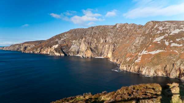
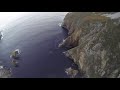
The approach to Slieve League is quite an experience before even start walking, the road twists and turns, with big unprotected drops down into the Atlantic below. The carpark (
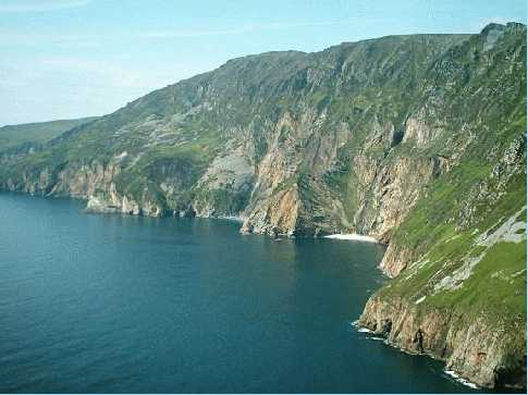
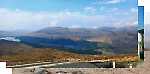
F (G557 757)) gives a fantastic vista of the steep high sea cliffs and the walk to come, with great views out over Donegal Bay.
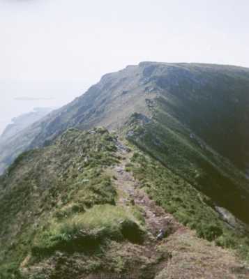
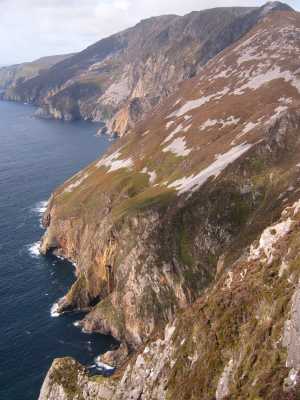
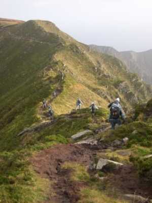
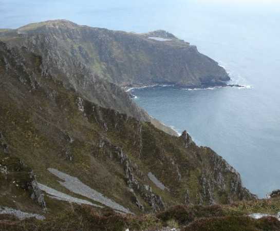
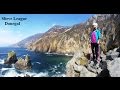
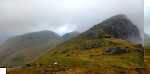
There is a good path from the carpark and its informative information board, along stone steps and easy grass - this soon changes though and the track becomes quite heavily eroded through areas of peat and rock (a testament to the heavy traffic the hill no doubt attracts). There are breath taking views along the lenghth of the sea cliffs to Rathlin O Birne island. Soon come to a series of little jagged tops which contain the rib of rock already mentioned in other comments - I climbed up to its start but the steady breeze told me it was not a good idea to attempt and the easier track below won out. Ever higher vantage points have the hand reaching for the camera - be prepared for numerous stops to take pictures. After 1 hr 10 minutes i reached a large cairn and a level area at the summit. Continue along the cliff edge - looking back over the cliffs to the now distant carpark. There are cracking views to the Sligo Hills, along the Ox mtns to Nephin and then Corribinnia and Glencar in the Nephin Begs and to lands end at Belmullet. There are also good views N to the Derryveaghs and the Bluestacks.
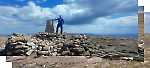
There are a number of cairns as travel easily along the cliff top before drop down and cross One Mans Pass - the narrow ridge leading to the true summit area - not really anything too worry about unless the wind was howling. The summit area has a "sawn off" trig pillar and a couple of small cairns, with views over to Leahan Mtn (427 m), Rathlin O Birne island with its lighthouse and N to the signal tower and the jagged top of Sturral Head further around this magnificent coastline. The E breeze was whipping down the cliffs and creating spreading patterns on the ocean below - a solitary fishing boat the only other disturbance.
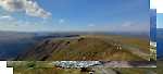
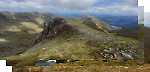
Return back along One Mans Pass to the first large cairn encountered on the climb, i noticed a perfect little igloo shelter built here. Take the E running spur above Lough Agh. there appears to have been some sort of competition here as i counted over 20 sizeable cairns. The going is very good on grass and small stones, with great views down over Lough Agh and across to the slopes which end abruptly at the huge sea cliffs. After reaching a cairn there is a drop down and a small rise to the top of Lergadaghtan Mtn (G (G566 678)4) - from here it is a steep drop down towards sheep pens and the Old Mans track. Follow the track to the road and turn L uphill, this joins the road to Bunglass, turn R and are back at the carpark after 50 minutes of road walking. Absolutely fantastic days walking and as was during the week there were only a few cars in the carpark. It is worthwhile heading down to the signal tower at H (G563 748). Linkback: mountainviews.ie/summit/285/comment/2289/
Read Less
Read More

            MountainViews.ie picture about Slieve League (<em>Sliabh Liag</em>)
Clunarra on Slieve League
by Clunarra 30 Sep 2003
My favourite mountain. The views are magnificent. But be careful here, mountain rescues are becoming a very regular occurrence on this one. Linkback: mountainviews.ie/summit/285/comment/687/
Read Less
Read More

            MountainViews.ie picture about Slieve League (<em>Sliabh Liag</em>)
Picture: A group from QUBMC crossing One Man's Pass
pdtempan on Slieve League
by pdtempan 7 Nov 2005
One Man’s Pass or Casán an Aonair in Irish is the name given to the ridge about 400m long immediately west of the summit of Slieve League. Keeringear (na Círíní Géar, ‘the sharp crests’) is a series of pointed peaks further east. The difficult rib of rock mentioned by murphysw is part of Keeringear. Bear in mind that most topographical names in Ireland were given by farmers, not climbers. One Man’s Pass may be easy for experienced mountaineers, but it is an unavoidable obstacle for anyone who wants to reach the summit from the east. The rib of rock on Keeringear, on the other hand, is much more challenging, but is easily skirted by keeping to the main path. It is therefore not a pass in any sense, but rather a rock-climbing challenge for those who want to push themselves. Such features didn’t usually get local names unless their shape was particularly striking or there was some folklore associated with them. Linkback: mountainviews.ie/summit/285/comment/2045/
Read Less
Read More

            MountainViews.ie picture about Slieve League (<em>Sliabh Liag</em>)
Picture: Looking back to the lake above upper bunglas car park and first half of the summit ridge
To Slieve or not to Slieve ...
by yambox 4 Aug 2011
Climbed Slieve League from Bunglas upper car park to top along the ridge on June 18th 2011.
Much has been said about Slieve League.
It is a very popular spot for tourists, but they usually stop up the little hill past the upper Bunglas car park. You can always try to park your car at the upper car park, but there's only limited space. Therefore it is recommended to park the car at the lower Bunglas car park left from the closed gate on the road.
From the upper car park, just follow the ridge with the sea at your left hand side. The path is obvious and damaged by many thousands of hillwalkers that come here every year. (On the panel you can see that the authorities don't mention this path anymore, only the pilgrim way is indicated).
You will have to take the one man's pass : 25 m of easy rock with the sea 500 m below. I wouldn't pass it in wet and windy conditions, but otherwise little risk. At the platform go further west and pass the one man's path, a small but easy path towards the summit area. People who have been climbing in the Alps will take both obstacles with the smile on their faces...
Go back the same way or take the pilgrim path if you have more time.
Plenty of kicks when walking this ridge ... disadvantage however is further damage to the path and the ridge with its fragile eco-system ... Linkback: mountainviews.ie/summit/285/comment/6463/
Read Less
Read More
EDIT Point of Interest
text
Videos


Recent Contributions
x
Conditions and Info
Use of MountainViews is governed by conditions and a privacy policy.
Read general information about the site.
Opinions in material here are not necessarily endorsed by MountainViews.
Hillwalking is a risk sport. Information in comments, walks, shared GPS tracks or about starting places may not be accurate for example as regards safety or access permission. You are responsible for your safety and your permission to walk.
See the credits and list definitions.

OSi logo
OSNI/LPS logo
Open Street Map
(Various variations used.)
British summit data courtesy:
Database of British & Irish Hills