This website uses cookies, which are small text files that the website puts on your device to facilitate operation. Cookies help us provide a better service to you. They are used to track general user traffic information and to help the website function properly.
Feature count in area: 24, by county: Tipperary: 18, Limerick: 8, of which 2 are in both Limerick and Tipperary,
OSI/LPS Maps: 66, 74, EW-G
Highest Place: Galtymore 917.9m
Starting Places (19) in area Galty Mountains: Aherlow House Hotel, Annaslinga, Attychraan Loop Trail, Cahirabbey Upper, Carrigeen, Clydagh Bridge, Combaun Woods CP, Combaun Woods Track, Galtyway Climb Black Rd, Glengarra Woods, Kilmoyler Railway Boreen, Kings Yard, Lake Muskry Trailhead, Lissantrelick Paradise Hill, Lisvernane, Pigeonrock Behanagh Rivers fork, Scaragh Reservoir, Scarragh Wood S, Scarragh Wood W
Summits & other features in area Galty Mountains: Cen: Central Galtys: Cush 641.2m, Galtybeg 799.2m, Galtymore 917.9m, Greenane 801.3m, Greenane West 787m, Knockastakeen 581.6m, Knockeenatoung 601.3m, Lough Curra Mound 600.4m, Seefin 446.6m, Seefin North Top 444.1m E: East Galtys: Laghtshanaquilla 629.4m, Laghtshanaquilla North-East Top 598m, Slieveanard 437.8m, Slieveanard NE Top 448.5m, Sturrakeen 541.7m N: North Galtys: Slievenamuck 369m W: West Galtys: Benard 479.5m, Carrignabinnia 822.9m, Knockaterriff 691.6m, Knockaterriff Beg 679.3m, Lyracappul 824.9m, Monabrack 630.1m, Slievecushnabinnia 774.8m, Temple Hill 783.1m
Note: this list of places may include island features such as summits, but not
islands as such.
Galtymore, 917.9mMountain Cnoc Mór na nGaibhlte A name in Irish,
Place Rating ..
(Ir. Cnoc Mór na nGaibhlte [GE], 'big hill of the Galtees') County Highpoint of Limerick & Tipperary and in Limerick/ Tipperary counties in Munster province, in County Highpoint, Arderin, Vandeleur-Lynam, Irish Highest Hundred, Irish 900s Lists, Galtymore is the highest mountain in the Galty Mountains area and the 14th highest in Ireland. Galtymore is the highest point in county Limerick and also the highest in Tipperary.
Grid Reference R87846 23788,
OS 1:50k mapsheet 74 Place visited by: 1330members, recently by: Muscles1960, GerryAlex, david bourke, kieran117, kelleher, rhw, purpleknight, MartMc, claireod5, KimCooke, MeabhTiernan, laurajobyrne, Deirdreb, discovering_dann, orlaithfitz
I visited this place: NO (You need to be a logged-in member for this.)
Longitude: -8.17915, Latitude: 52.365985, Easting: 187847, Northing: 123788,
Prominence: 820m, Isolation: 1km, Has trig pillar
ITM: 587799 623838 Bedrock type: Conglomerate & purple sandstone, (Slievenamuck Conglomerate Formation) Notes on name: The summit of Galtymore is marked as Dawson's Table. Captain Dawson was a landowner in this area (Tipperary Directory 1889). Cf. Percy's Table on Lugnaquillia. The diarist Amhlaoibh Ó Súilleabháin (Humphrey O'Sullivan) recorded a different Irish name for the peak: Beann na nGaillti (Cinnlae Amhlaoibh Ó Súilleabháin, iv, 102). The names of three nearby places are derived from this: Glencoshnabinnia (PWJ, iii, 366), Slievecoshnabinnia and Carrignabinnia. The anglicised name Galtymore is recorded as early as the Civil Survey of Co. Tipperary (Down Survey, 1654-56), where it is mentioned (spelt exactly as today) as a boundary feature of the barony of Clanwilliam.
Short or GPS IDs, 6 char: Gltymr, 10 char: Galtymore Linkback: https://mountainviews.ie/summit/14/
Gallery for Galtymore (Cnoc Mór na nGaibhlte) and surrounds
Summary
for Galtymore (Cnoc Mór na nGaibhlte):
Steep, airy and grassy highpoint of a long east-west ridge
Summary created by markmjcampion, jackill
2023-08-16 16:30:43
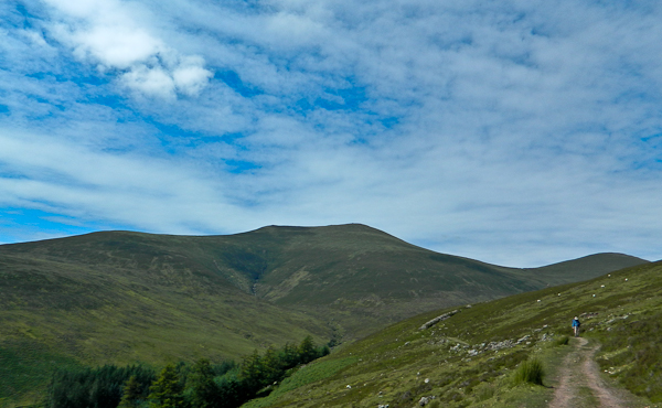
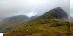
Picture: Galtymore from near the Black road
Galtymore is one of the country’s ten highest peaks and commands sweeping views over much of the S midlands incl. the Ballyhouras, Knockmealdowns, Comeraghs and Mt. Leinster. It has a lot of v steep ground and some fine corries on its northern face so take care esp. in poor weather. There are plenty of route choices with well-defined trails.
SSE Park at the top of The Black road Galtwy Rd (R89306 20345). This popular route follows a rocky, easy to follow track all the way to A (R89345 23482) (637m), go left here and follow the stony (becoming muddy) track to the col between Galtymore and Galtybeg (or take in G’beg first), from where there’s a steep pull, uneven to the top. This is a short up and down circa 12k and 4 hrs.
S There is a rocky track from Kings Yard King Yd (R87526 19959) which becomes boggy after the sheep pen at B (R87409 21077) and ends at approx. C (R87551 22234). After that you need to navigate to the stone wall at D (R87149 23518) and from there it’s an easy walk to the summit. [5k to top with 715m asc]
N. From Clydagh Bridge, where there is a big carpark at Clyda Brg (R87450 27780) there are a couple of options : a classic horseshoe taking in Cush and Galtybeg [15k in total 1200m asc] or a more direct approach which brings you first to Lough Curra followed by a steep climb to E (R86447 23952) [7k to top with 750m asc]
It’s also possible to take in this summit as part of a long distance traverse of the whole of the range.
Notable tracks incl. track/2076, track/3772 and the lengthy track/2766.
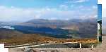
If you want to see Galtymore at its best then the classic northern horseshoe is far superior to the approach from the south (but you forego the advantage of the high start, so it's much steeper and more energetic). Plenty of parking half a mile up the boreen east of Clydagh Bridge, then follow the easy forest tracks, well waymarked as the route to Lough Curra. Eventually this leaves the forest and goes up fairly steeply to a minor peaklet with a big square block. From here the waymarked route goes off left, but a smaller but clear path goes straight on up past a prominent big cairn to the broad plateau of Slievecushnabinnia. Note that the summit is at the west end, not where shown on the OSi map (grid ref correct on MV). A wall takes you eastwards up to a shoulder of Galtymore, with great views down to Lough Curra, then a steeper pull up to the summit (which isn't the first cairn, although in mist it feels like it should be). There is a white cross just before the proper summit, which has a broken trig point as well as a big cairn. A brief detour to the northern edge gave me a great Brocken Spectre, a nice way to celebrate a second round of UK & Irish 3000 footers. The descent eastwards is steep but easy, then a short pull takes you onto Galtybeg, with a short bit of nice sharp ridge. The views back to the NE face of Galtymore are excellent (with quite an impressive icefall on it when I was there, wonder if it's been climbed?). The first part of the descent towards Cush is quite steep, with something of an "am I about to walk over a cliff?" feel at first, but it soon eases. Cush is a fair pull too, but well worth it for the lovely perch on the summit. I had four ravens wheeling around for entertainment too, probably complaining that I'd nicked their seat! A good path takes you down the NW shoulder to meet the boreen just above the car park. It's about 14km with 1150m of ascent, so "quite a pech", but worth it! Linkback: mountainviews.ie/summit/14/comment/20399/
Read Less
Read More
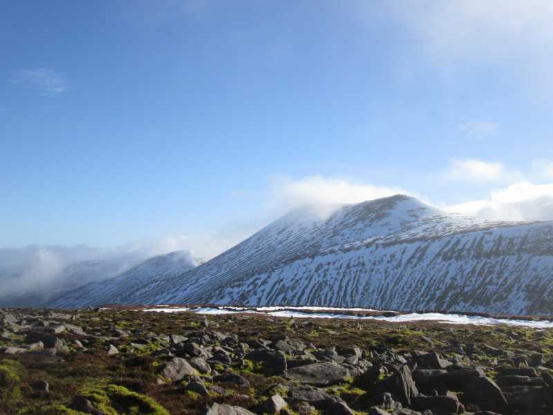
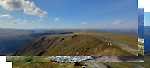
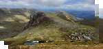
Picture: Galtee Gradients
Galtee Gradients
by omurchu
22 Jun 2022
A side-on view of Galtymore showing the gradient of its north facing side alongside those of Slievecushnabinnia, Galtybeg and Greenane West. Linkback: mountainviews.ie/summit/14/comment/23561/
Read Less
Read More
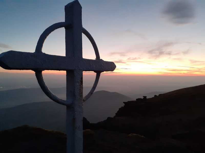
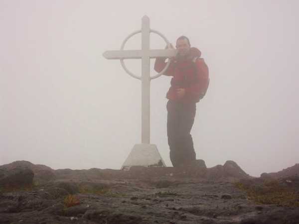
Picture: Living on the edge!!
Clinging on for dear life!
by Dessie1
14 Nov 2011
Climbed Galtymore 13 Nov 2011 from Black road route Galtwy Rd (R89284 20381) incorporating Knockeentoung,Galtybeg,Galtymore and finishing with the 2 seefins in a 3 hour 20 mins circuit.Unbelievably windy on the summit so only a brief stay for a few pics.Will definitely be back on a clearer day.
Main walk Length:12.7km Start: 08:44, End: 12:02, Durn: 3h18m, Asc: 1045m, Desc: 925m Linkback: mountainviews.ie/summit/14/comment/6625/
Read Less
Read More
sduce on Galtymore
by sduce
24 May 2009
As an absolute novice at hill walking, this was my highest peak so far, i have been fascinated by Galtymore for years, love the fact that you can see it from everywhere or so it seems..... We climbed saturday 23rd May, lovely weather, and came up the black road, to the base of Galtybeg, before heading off over the rough ground and bog towards the col between Galtybeg and Galtymore, after resting a while there (not actually the best spot, windy and damp for sitting!) admired the cliffs, took lots of photos, and pondered weather my unfit and middleaged frame would actually get me up, what now looked a very steep ascent to Galtymore, well I made it, took ages! and it was certainly worth it, fantastic weather and view from the top all I ever thought they would be. Spent a half an hour on the summit just enjoying it.
It took me 4 hours to summit, (although I am sure 2 and a half would do it - if there was not quite so many 'rests' and sandwich breaks!) and about 1 hr 45 mins back to the car park. Which was easy enough, I would also at this point like to thank the couple who we met at the summit, and outstripped us going home, but appeared to wait at least half and hour in the car park to make sure we got down ok as the light was starting to fade at 9.45pm. A sincere thank you, a very caring gesture.
In short I would like to inspire anyone who reads this to climb Galtymore (or indeed anything else you fancy) if you are just reading this site, and dreaming like i was for so long .... if i can do it anyone can!
Sarah Linkback: mountainviews.ie/summit/14/comment/3779/
Use of MountainViews is governed by conditions and a privacy policy.
Read general information about the site. Opinions in material here are not necessarily endorsed by MountainViews.
Hillwalking is a risk sport. Information in comments, walks, shared GPS tracks or about starting places may
not be accurate for example as regards safety or access permission. You are responsible for your safety and your permission to walk.
See the credits and list definitions.


 Our Facebook page.