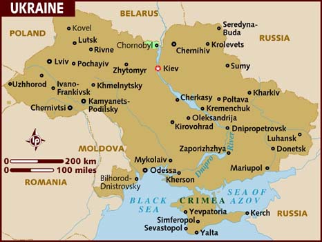
Ukraine is in Eastern Europe, between Poland and Russia. The country is vast and borders quite a few number of countries in the region. Ukraine borders with Belarus to the north, north and east with Russia, south to the Azov and Black Sea, and west to Romania, Moldova, Hungary, Slovakia and Poland.
Ukraine has 603,628 square kilometers of land area (375 077 square miles) and is the 44th largest country in the world. Ukraine is the 2nd largest country in Europe after Russia, while France is the 3rd largest.
The highest point in Ukraine is in the Carpathian Mountains, at the Hora Hoverla peak that rises up to 2,061 meters (6761 feet).


Leave a comment