 Route Editor

| Guide | ♦ | 37 Triplogs | 2 Topics |
details | drive | permit | forecast | 🔥 route |
stats |
photos | triplogs | topics | location |
| 237 | 37 | 2 |
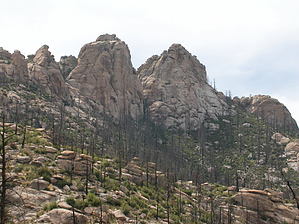
Tough but rewarding by Wildcat04 Cathedral Rock is the highest point in the front range of the Santa Catalina Mountains, at an elevation of 7,952 feet. Thus, it provides unobstructed views of the Tucson valley and nearly all the mountain ranges surrounding the city. Though the inspiring vista is the most fulfilling part of the journey for most hikers, there is also something to be said for the satisfaction gained during the climb to the top. The beginning of the Esperero Trail can be found just up the road from the visitor's center of the Sabino Canyon Recreation Area. It passes a picnic area before heading uphill and then drops down into Rattlesnake Canyon, which is a vast expanse of desert scrub and saguaro. The trail starts heading west and crosses into Bird Canyon before heading due north up the east canyon wall, and eventually crosses and re-crosses a drainage, which should be completely dry. After about 2.5 miles, the trail switchbacks up a steep slope and arrives at a saddle overlooking the city, which is a perfect lunch and/or rest spot. At this point, the vegetation has changed to grassland.
The two miles of winding through Esperero Canyon are shady, cool, and somewhat spooky. The forest is rather thick and gives one the feeling of being in an isolated wilderness far from humanity. Bridal Veil Falls, at 5.5 miles, is a popular feature of this section, which can be found off to the left of the trail. When water is present, it creates a small waterfall that looks like a bridal veil, hence the name. There are some camping spots in this area, and a chance to fill up your water bottle, given that you have a filtering system of some type. The trail leaves the woods and climbs gently through rocky grassland and juniper before reaching a junction at 6.4 miles from the trailhead. Staying on the Esperero Trail will take you northwest to The Window, a dominant feature of the Catalinas front range. Turning right onto the Cathedral Rock Trail will direct you toward the destination of choice on this hike. The next 1.8 miles are somewhat rocky and steep before arriving at Cathedral Rock Saddle, which, although it overlooks the city of Tucson and the back of the Catalinas, is not the most scenic point of the trip. At the saddle, be sure to turn left, or to the northwest (turning right will drop you down onto the West Fork Trail). This section is perhaps the most difficult to navigate because the trail is extremely faint; you will have to follow the cairns up to Cathedral Rock. Once you arrive at the base of the rock, you will see a black rope strategically placed to help pull yourself up. The views from Cathedral Rock are breathtaking. Stepping onto a flat ledge, you are now up higher than anybody for miles around. However, climbing to the very highest point of this feature requires technical mountaineering ability and proper gear. In other words, do not try it unless you know what you are doing. A fall could be disastrous. Over the course of this 9.1-mile journey, the hiker will have seen saguaros, grassland, pines, and a diversity of plant life journeyed through thick forests and rocky slopes, and perhaps have spotted some interesting wildlife in the process. Every fan of the Catalinas should visit Cathedral Rock via the Esperero Trail at least once in their hiking adventures. It is sure to be a memorable experience. I recommend hiking this trail during the spring or autumn. The summer months can be quite dangerous on this trail because of its exposure to lightning in some sections (especially at Cathedral Rock). The lower sections are very long and can make a hiker vulnerable to heatstroke. Winter weather can pose just as much of a risk, considering that the last mile up to your destination may be icy and filled with snow. Check out the Official Route and Triplogs. Note This is a difficult hike. It would be insane to attempt this entire hike without prior experience hiking. Leave No Trace and +Add a Triplog after your hike to support this local community.
| ||||||||||||||||||||||||||||||||||||||||||||||||||||||||||||||||||||||||||||||||||||||||||||||||||||||||||||||||||||||||||||||||||||||||||||||||||||||||||||||||||||||||||||||||||||||||||||||||||||||||||||||||||


